• Happy National Garlic Day! 🧄🚫🧛🏼‍♂️

Delmarva Peninsula Paddling

G

Guest

Guest
"Top Ten on the Eastern Shore" sounds like a new thread you need to start, Mike. I assume it includes -- Pocomoke, Dividing Creek, Nassawango,Transquaking and the aforementioned Tuchahoe. That leaves five. Also, curious as to the order you rank them. I'm gonna try to knock some more of these off before the season ends.

Yes, all of those, and I can’t possibly rank them; my favorites are all different, at different times and different seasons. There are 70+ paddle-able creeks and rivers on the Delmarva, thousands if you count the edges of the Chesapeake Bay and weird urban stuff not included in most guidebooks. Prepare to get busy.

There is not a lot of river tripping potential on the Eastern Shore, although lots of sea kayak tripping along the shoreline Chesapeake Bay, and, uh, “stealth camping” opportunities back in the uninhabited environs. On the other hand there are a lot of riverside State Parks in which to base camp and day paddle.

What the heck, for anyone Delmarva-curious, my Top Ten eastern shore peninsula paddles. In no particular order, each somewhat (or very) different from another.

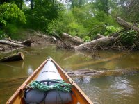
Transquaking River loop. Gertler called Dorchester County Maryland’s version of the Everglades. The highest point in Dorchester County is 60 – 70 feet above sea level. A lot of Dorchester is mere feet above (um, current) sea level. See it before it goes under, and bag your first “highest” peak near Hynson. Don’t trample the soybeans on your way out.

https://www.peakbagger.com/peak.aspx?pid=23026

Tuckahoe Creek. The closest Grade A paddling venue east of the Bay Bridge. I’m looking forward to your trip report, that creek is Delmarva special. Maybe the quickest and easiest road shuttle ever. Solo trip bike-able too; leave the canoe secured at the State Park, drop the car in Hillsboro, bike back along a flat distance (shorter than the 5 miles of twisty river), lock up the bike in the Park, paddle down and drive back to collect the bike.

The Pocomoke Swamp deserves at least three picks; Pocomoke River from Porters Crossing to Snow Hill, Nassawango Creek from Red House to Snow Hill, and Dividing Creek up and back from Pocomoke City. All within 30 minutes drive of each other at the Milburn Landing section of the State Park. Shuttle service available from the outfitter in Snow Hill.

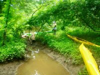
Hitch Pond Branch/James Branch downstream of Trap Pond SP to the ramp on Records Pond. Especially if there is water coming over the dam, and someone has cleared the strainers; it’s only 3 feet wide at times (wider boats are comical to behold stuck), and so tightly serpentine between banks that a canoe longer than 17’ will not make the turn before broaching each stem. Worth pursuing; it’s a freaking knobby kneed fairyland in spring bloom, birdsong and skimmer hatch. Yeah, that one is special too.

Prime Hook Creek from Rte 1 to the Wildlife Refuge (check with the Refuge, the creek and marsh are closed to paddling during portions of goose and duck migration). Paid parking (couple bucks) in the trailer park alongside Rte 1. Also a flat easy bike shuttle down to the Refuge for a solo sufficient trip.

Chincoteague Bay behind Assateague Island, as an off-season paddle in camper. One of my favorite places on earth; I’ve been going there since the early 70’s, and I’m still learning/finding things. Love that place.

Island Creek and Pokata Creek on the uninhabited Elliott Island peninsula (just east of the Transquaking). Up less than a mile of Pokata, and up as far on Island Creek as you care. 8 or 9 miles up is possible, with massive side sloughs to explore (remember, you still need to paddle back). Rising tide on the way up, free suck ride on the way back if you make a day of it. Or very free ride on the way back; that’s another story.

Down Pitts Creek and up Little Mill Creek on the MD/VA border. If you don’t find the obscure entrance to Little Mill Creek and your shuttle vehicle parked a mile upstream you are well and truly screwed. The next landing is on the far side of the Pocomoke in Shelltown, a long ways from the take out car.

I left some out, like circumnavigating Wye Island from Wye Landing Rd. Or Janes Island State Park, which does have a couple paddle-in “back country” sites, and 40 miles of marked trails.

http://dnr.maryland.gov/publiclands/pages/eastern/janesisland.aspx

Gawd, there is a lifetime’s worth of varied paddling water just on the Delmarva.
 
Tuckahoe creek still has many blockages. Was just there last Saturday.

Dividing creek is a very nice paddle.

Also add to the list the upper Choptank. For a strainer free paddle, do Greensboro up to the weir and back on the tide. For a more physical workout, bring your shears and go from the weir up toward Mud Pond. Mud pond itself is actually a nice paddle when the swamp flowers are blooming.
 
Last edited:
Tuckahoe creek still has many blockages. Was just there last Saturday.

That’s too bad; I wonder if some group or organization had been keeping it clear.

I haven’t been down that stretch of the Tuckahoe in a couple years, but have paddled it a dozen times previously and never had many strainer issues. Some barely submerged speedbump logs and limbo-under logs, but rarely anything that required stepping out of the canoe.

I wonder if the extreme wet over the last year loosened the grip of some bankside leaners.
 
Serendipitously, DNR announced two days ago they have removed all the blockages. So, Thursday I am leading a Chesapeake Paddlers Trip there and we will try it. Up and back from Hillsboro. I am still bringing a saw and shears. If you want to come, let me know - we insist on wearing pfds, and you'll need to sogn a waiver, but should be a nice paddle.
 
For those interested in what the swampy portion of the Pocomoke River looks like, these videos are pretty representative. It is indeed a beautiful, peaceful float. And, due to the tannins from the bald cypress trees, apparently completely mosquito free.


"And, due to the tannins from the bald cypress trees, apparently completely mosquito free". HaHa. You need to spend an evening and night in there.
 
Please appreciate how fortunate you are to have floated Porters Crossing to Snow Hill in quiet solo mode. I am envious.

In many dozens of trips on the Pocomoke, Nassawango and Dividing I have never been without companions. Sometimes just a few, sometimes a dozen or more. Love hearing the quiet of birdsong instead of voices and thumps.

I may have to follow your lead and pay the whopping $20 shuttle for an early morning solo shuttle from Snow Hill to Porters, or down Nassawango and up to the outfitters if the tides are right. I wonder how dawn-ish they would agree to meet me? Sunrise in the swamp is a very special time.

Milburn Landing is as good as it gets for a State Park base camp, with a half dozen each-different day paddling venues in easy driving reach, and shuttle serviced for some if needed.

Even tidal night floats up/down the Pocomoke were (almost) always with companions, having non-participatory folk drop a group off upriver at Shad Landing or down at Pocomoke City and drive our cars back while we floated the tidal action back to camp at Milburn.

One spring tide night float, going with middle-twelfths tidal flow trip, combined with a tail wind, was enough that we nearly beat the shuttle drivers back to camp. Shoulda just floated rafted-up the whole way, and set the record a 5 mile no-paddle muckle-up.

With quiet companions the tidal Pocomoke makes for an awesome night float, especially when the barred owls start calling back and forth across the river, the tree frogs and cicadas are croaking and buzzing, and weird river slaps and splashes are resounding. Those visual and auditory inputs awaken the primal senses.

The occasional fish, mammal or turtle splash is “What’s that?” ears perked instant awareness. heck, it even smells primeval back in the muck, and the water somehow feels oddly inky-dark tactile different when spilling off a quiet paddle blade. Agnosia at its temporary finest, with all of the customary senses weirded out in silent darkness.

The spookiest part of a night float on the Pocomoke has been the moonless nights, when the twists and turns make it appear as though the river somehow mysteriously ends up ahead.

About bugdom. Later in summer the mosquitoes are unavoidable; not as bad up in fresh water tannin flow swamp as the varieties of salt marsh mosquitoes further downstream in tidal areas. Usually better on the freshwater upper river than back hanging around in windless pine forest swamp camp.

Let’saa just say there are 59 species of mosquitoes in Maryland, and most of them inhabit the eastern shore in one environment or another, and some of the hearty salt marsh varieties will hatch swarms on a warm day in December. YMMV.

The bigger summer bug annoyance in is deer flies. Also multiple species, most colliqually called “Greenheads” in the local vernacular. Deer flies are attracted by movement, so it’s always best to allow another canoe to lead the way on narrow stuff and collect the awaiting swarms. “No, really, my pleasure, after you”.

So kind of me. Hang back 30 feet or so off their stern for a near fly-free passage. That only works with the un-introduced one time.

In camp if someone proves deerfly or mosquito delectable you can shag your swarm off on them with a Davidson & Rugge style lingering pass off. That must be a respected technique, it’s in the book.
 
I was extremely apprehensive about moving up to Aberdeen last year... pleased with the local waters/paddling (and finally have full time access to my Chum!), less so with the local 'camping' opportunities. Finding "tides" a bit odd, but am learning. Thanks for the locations/tips.
 
Well, six of us did the Tuckahoe yesterday. Launched from Hillsboro ramp on the last hour of high tide, and headed up stream. Of the three major blockages that had existed two weeks ago, the first teo were gone, but the third was cut in a way that would only be passable if we had at least six more inches of water inder our keels. So we ended up doing a small portage river left. Luckily involving no poison ivy. About a mile on, we end ed up at a blockage that we could drag over by having me get out of the boat, straddle one of the logs, and help pull each boat across.

Othere than those two spots, the Tickahoe is clear from ramp to dam.
 

Attachments

  • photo11767.jpg
    photo11767.jpg
    264.6 KB · Views: 0
  • photo11768.jpg
    photo11768.jpg
    573.5 KB · Views: 0
  • photo11769.jpg
    photo11769.jpg
    651.2 KB · Views: 0
Looks like a good trip! Here in NE on our small rivers we have a lot of log jams and carry over/around as well. Year to year it's always different. Looking at the pictures I was wondering A) What boat are you paddling? I noticed no deck B) Is your float bag tied in somehow? I can't really imagine a dump on a tidal river but if it happened how would the bag help?
 

Attachments

  • Humping.jpg
    Humping.jpg
    200.2 KB · Views: 0
I am paddling a Hornbeck classic 13. Floatbags are secured by their corner rings to the bow, and the nearest thwart. The creek is only tidal for about two of its miles above the launch. Since the only other floatation in the hornbeck is the seat foam, the bags keep the hornbeck from sinking, and keep it high enough that I can do a paddlefloat reentry if too far to swim or wade to shore. Without the bags, doing a paddlefloat rentry just sinks the boat.

i don't paddle boats that can't float high enough to pump out when flooded and I am sitting in them.
 
Last edited:
I've paddled one Hornbeck years ago. A joy and even better to lift compared to a lot of my boats! Sounds like you have the float bags figured out for that boat! Thanks
 
Back
Top