I've been enjoying the various trip reports here, so I thought I would write up the short solo trip I took last weekend. I only had a one night kitchen pass, but I was in the mood to put some miles on the odometer, so I decided to head up to Chesuncook Lake in northern Maine, just south of the Allagash Wilderness Waterway. It's about two hours drive from home for me, so close enough for a weekend trip.
Chesuncook is a really big lake, around 20 miles long, and when the wind is bad it's totally uncanoeable. However, the forecast for the weekend was for benign conditions (more on that later). The usual access is at the south end of the lake, and there's a large island (Gero) at the north end with several campsites. My plan was to paddle up to Gero and camp there Saturday night, then paddle around it and back down the lake on Sunday.
The landing on Chesuncook is about as far northwest as you can go in Maine without passing a North Maine Woods checkpoint (and coughing up a few extra shekels). For this trip, the only cost was $6.54 for a night of camping in the Penobscot River Corridor. Cheap date. Dirt colored Subaru not included.

I got on the water about 10:15am. Just as I was leaving a party of a dozen or so teenagers was coming in, presumably from a West Branch trip. I actually saw very few people on the water, and only one of the ten or so campsites I passed was full. Where was everybody, on a sunny weekend in July? I'd been worried that I'd get up to the top of the lake and not be able to find a campsite, but in the end there was plenty of space.
For the first couple hours the lake was amazingly smooth. One motorboat passed, headed north in the middle of the lake, and it seemed to take forever for its wake to reach me. I generally followed the eastern shore, but I could have crossed the lake without concern. I stopped on Mouser Island for an early lunch (only 1 of 3 campsites taken).
The wind gradually picked up, and by the time I passed Weymouth Point there was a significant headwind and some middling waves, but I was full of beans and happy to be working my way up the lake.

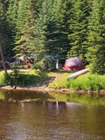
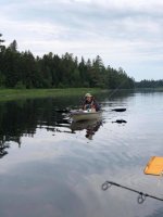
By the time I reached the open area south of Gero the waves were high enough that I didn't want to take the direct route, a crossing of about 1.5 miles, so instead I cut east across Cuxabexis Cove to get a shorter crossing. Soon I was at the south end of Gero, and looking for a campsite (I was still worried about those hypothetical summer crowds). The southwest shore of Gero Island is a series of points and coves, and each point looked to me like it would make a nice campsite. After four or five small points, I got to Gero 4, found it unoccupied, and decided to camp there. Two sources (AMC Quiet Water and Frank Richards) had said all the campsites on Gero are great, so I didn't feel the need to shop around. It was only about 3pm, but I'd been going into the wind for hours and was ready to relax. It was too early for dinner, so I made some tea, pitched my tent, and played with my waterproof camera.
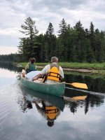
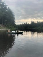
This is a still from me trying to figure out Robin's camera-on-a-paddle thing. It didn't occur to me until afterward that I had the camera aimed down the blade. Duh! So, please excuse the Carlisle beavertail in the foreground.

The campsite was indeed great, with a rocky deepwater port, a gravel beach, and tent pads looking out northwest toward Chesuncook Village and the setting sun. I had a simple dinner and retired early to my tent.

In the morning, I got on the water around 7:30 and headed north, intending to paddle around Gero clockwise. It had occurred to me that going around the island was adding ~7-8 miles to my trip, and while I was dilly dallying the wind would be building. But I wanted to go around the island, partly to overlap the route of a trip I made last summer when I camped at Longley Stream on my way up to Allagash Lake, and just for the general karma of circumnavigating something. For some reason a "lollipop" trip is better than a plain out and back. I also considered crossing over to Chesuncook Village to see if I could score a Circle K microwave burrito, but it was too early for lunch. So, around the island I went.
It was a quiet trip around the island and I turned down the main stem of the lake around 9:30. No moose, but one deer and two bald eagles. As expected, the wind strengthened as the day warmed up. I stopped at the long sandbar near Red Brook campsite for a snack. That would be a great place to swim, but I knew I needed to keep moving. Given the wind direction I figured Weymouth Point would be the main hurdle.

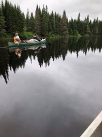
This was my ride for the trip, a beat up old Wenonah Jensen C1W, circa 1984. It's a hull designed for downriver racing, and this one had been breached and patched a number of times before I bought it (and, I admit, continued the abuse). It's not as light or as smooth as it once was, but it still has pretty good glide. However, it's hard to turn and kinda squirrelly in a tailwind.
The weather forecast was for a north wind, 5 to 7 mph, which would have been almost ideal. Of course big lakes make their own wind, so I figured I'd get more than 5 to 7, but I'd be following the favorable shore. However, as the day wore on the north wind was becoming more northwesterly, and given the orientation of Chesuncook, a NW wind is not a good thing. The shoreline I was following consisted of sandy coves and rocky points. I had to stay far enough "out to sea" that I could pass the points while holding a good angle to the waves, but I also wanted to be close enough to shore that I could bail if need be. By the time I got to Mouser Island the waves were at the edge of my comfort zone and I was glad to be able to take a break behind it. Past the outlet of Holmes Hole things got a bit more hairy and I pulled in behind some rocks to wait it out. It was amusing to be windbound less than two miles from my car, but so I was. Fortunately the wind wasn't constant, and after 15-20 minutes it moderated somewhat and I made a run for it. After another half a mile the shore was in the wind shadow of the peninsula to the West, reducing the fetch, and I was home free. I arrived at the boat landing around 2pm.
All in all a great short trip. I wasn't out very long, but I got a "wilderness reset", and some exercise. In hindsight, it might have been wiser to get an earlier start on Sunday, but whatevs. I'll definitely be back. Much more to explore in the area, including Pine Stream.
Chesuncook is a really big lake, around 20 miles long, and when the wind is bad it's totally uncanoeable. However, the forecast for the weekend was for benign conditions (more on that later). The usual access is at the south end of the lake, and there's a large island (Gero) at the north end with several campsites. My plan was to paddle up to Gero and camp there Saturday night, then paddle around it and back down the lake on Sunday.
The landing on Chesuncook is about as far northwest as you can go in Maine without passing a North Maine Woods checkpoint (and coughing up a few extra shekels). For this trip, the only cost was $6.54 for a night of camping in the Penobscot River Corridor. Cheap date. Dirt colored Subaru not included.
I got on the water about 10:15am. Just as I was leaving a party of a dozen or so teenagers was coming in, presumably from a West Branch trip. I actually saw very few people on the water, and only one of the ten or so campsites I passed was full. Where was everybody, on a sunny weekend in July? I'd been worried that I'd get up to the top of the lake and not be able to find a campsite, but in the end there was plenty of space.
For the first couple hours the lake was amazingly smooth. One motorboat passed, headed north in the middle of the lake, and it seemed to take forever for its wake to reach me. I generally followed the eastern shore, but I could have crossed the lake without concern. I stopped on Mouser Island for an early lunch (only 1 of 3 campsites taken).
The wind gradually picked up, and by the time I passed Weymouth Point there was a significant headwind and some middling waves, but I was full of beans and happy to be working my way up the lake.
By the time I reached the open area south of Gero the waves were high enough that I didn't want to take the direct route, a crossing of about 1.5 miles, so instead I cut east across Cuxabexis Cove to get a shorter crossing. Soon I was at the south end of Gero, and looking for a campsite (I was still worried about those hypothetical summer crowds). The southwest shore of Gero Island is a series of points and coves, and each point looked to me like it would make a nice campsite. After four or five small points, I got to Gero 4, found it unoccupied, and decided to camp there. Two sources (AMC Quiet Water and Frank Richards) had said all the campsites on Gero are great, so I didn't feel the need to shop around. It was only about 3pm, but I'd been going into the wind for hours and was ready to relax. It was too early for dinner, so I made some tea, pitched my tent, and played with my waterproof camera.
This is a still from me trying to figure out Robin's camera-on-a-paddle thing. It didn't occur to me until afterward that I had the camera aimed down the blade. Duh! So, please excuse the Carlisle beavertail in the foreground.
The campsite was indeed great, with a rocky deepwater port, a gravel beach, and tent pads looking out northwest toward Chesuncook Village and the setting sun. I had a simple dinner and retired early to my tent.
In the morning, I got on the water around 7:30 and headed north, intending to paddle around Gero clockwise. It had occurred to me that going around the island was adding ~7-8 miles to my trip, and while I was dilly dallying the wind would be building. But I wanted to go around the island, partly to overlap the route of a trip I made last summer when I camped at Longley Stream on my way up to Allagash Lake, and just for the general karma of circumnavigating something. For some reason a "lollipop" trip is better than a plain out and back. I also considered crossing over to Chesuncook Village to see if I could score a Circle K microwave burrito, but it was too early for lunch. So, around the island I went.
It was a quiet trip around the island and I turned down the main stem of the lake around 9:30. No moose, but one deer and two bald eagles. As expected, the wind strengthened as the day warmed up. I stopped at the long sandbar near Red Brook campsite for a snack. That would be a great place to swim, but I knew I needed to keep moving. Given the wind direction I figured Weymouth Point would be the main hurdle.
This was my ride for the trip, a beat up old Wenonah Jensen C1W, circa 1984. It's a hull designed for downriver racing, and this one had been breached and patched a number of times before I bought it (and, I admit, continued the abuse). It's not as light or as smooth as it once was, but it still has pretty good glide. However, it's hard to turn and kinda squirrelly in a tailwind.
The weather forecast was for a north wind, 5 to 7 mph, which would have been almost ideal. Of course big lakes make their own wind, so I figured I'd get more than 5 to 7, but I'd be following the favorable shore. However, as the day wore on the north wind was becoming more northwesterly, and given the orientation of Chesuncook, a NW wind is not a good thing. The shoreline I was following consisted of sandy coves and rocky points. I had to stay far enough "out to sea" that I could pass the points while holding a good angle to the waves, but I also wanted to be close enough to shore that I could bail if need be. By the time I got to Mouser Island the waves were at the edge of my comfort zone and I was glad to be able to take a break behind it. Past the outlet of Holmes Hole things got a bit more hairy and I pulled in behind some rocks to wait it out. It was amusing to be windbound less than two miles from my car, but so I was. Fortunately the wind wasn't constant, and after 15-20 minutes it moderated somewhat and I made a run for it. After another half a mile the shore was in the wind shadow of the peninsula to the West, reducing the fetch, and I was home free. I arrived at the boat landing around 2pm.
All in all a great short trip. I wasn't out very long, but I got a "wilderness reset", and some exercise. In hindsight, it might have been wiser to get an earlier start on Sunday, but whatevs. I'll definitely be back. Much more to explore in the area, including Pine Stream.
") .
.