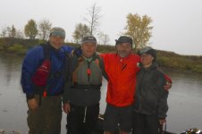
Here is another Connecticut River story, but no misadventures on this one. Tommy, Mena, Bill and I also spent Columbus Day Weekend on the Connecticut River. We ran the section from Bloomfield, VT (North Stratford, NH) to Lunenburg, VT (South Lancaster, NH).
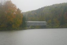
We drove up Friday afternoon and spent the night at the Belnap Campsite on the Nulhegan River. I woke up early on Saturday, made a cup of coffee, and walked over to the bridge over the Nulhegan River to watch the sunrise. The morning was cloudy so the sun was mostly obscured. By 7:00, everyone was up having breakfast and making plans for the day. We would put in at Debanville Landing (mile 348) and shuttle down to the Mount Orne Covered Bridge (mile 307) - a trip of 41 miles. By 9:30, we had run the shuttle and were getting underway.
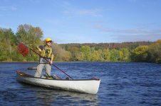
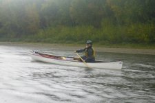
Once Bill and I got our gear to the put-in, we wondered if it would all fit in the boat. It did, but just barely. The river was wide, but very shallow at the put-in, so we had to wade out quite ways to find water deep enough to float the boat, and we still put in a couple of good scratches in the hull. We headed out under mostly sunny skies, but clouds rolled in as the day progressed, and we got some scattered rain in the afternoon. The foliage was just about peak, but with the cloudy skies it wasn’t as bright as I would have liked.
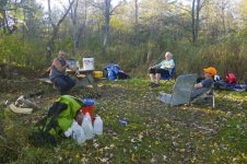
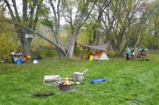
After 13 miles we arrived at the Samuel Benton Campsite (mile 334). The campsite is situated in a grove of trees on a sandy bluff at the edge of large hayfield. The nice grassy site gave us plenty of room to spread out. We set up camp, gathered some firewood, cooked supper, and gathered around the campfire for the night. The sun setting over the mountains was spectacular.
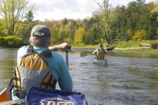
We got up on Sunday morning to fog and mist. The morning routine was similar to the evening – make coffee, get a small fire going, eat breakfast, break camp and head out. A light rain at about 7:30 got us moving quickly, and we were on the river by 8:30 heading downstream. The river continued to be shallow, but was not a boney as the previous day. Throughout the morning showers passed, so it was rain gear on, and rain gear off. As we passed the confluence of the Upper Ammonoosuc, the river opened up a bit.
After 11 miles, we approached the Maidstone Bridge and the Wyoming Dam Portage. Portaging the broken dam is suggested due to rebar, but even without the rebar it looked too boney to run at this level. Fortunately the rain let up as we hiked the portage trail. After a quick lunch we continued downstream to the South Guildhall Campsite.
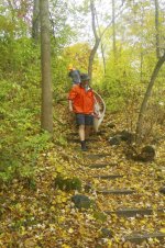
As we headed out, the wind picked up and rain came down in sheets. It looked like it would be long 5-mile slog down to the campsite. Fortunately, the rain and wind passed as quickly as it started, and we had clear blue skies as we pulled into the South Guildhall Campsite (Mile 317). The South Guildhall Campsite is a wooded site up a steep bank with great views of the White Mountains to the south. We lugged our gear up the stairs and followed our usual routine - set up camp, gather firewood, cook supper, and then gather around the campfire for the night.
I turned in at around 9:00, and woke up the next morning at around 5:30 to Tommy taking down his tent. The sky was cloudy, and it was pretty clear that it was going to be a rainy day, so he wanted to keep his tent dry. I figured I would have time for a cup of coffee, and I was right, but just barely. I had to race to get my gear packed before the skies opened up. We loaded the boats and were on the river by 7:30.
Monday was a short (10 mile) paddle down to the take-out at the Mount Orne Covered Bridge (mile 307). The river was wider and deeper in this section. It twists and turns through cornfields that seem to go on forever. The wind was calm, but the rain got heavier as the morning went on. We arrived at the Mount Orne Covered Bridge at around noon. We retrieved our cars, packed up our gear and said goodbyes before the long drive home in the holiday traffic. Great trip.
Video
https://vimeo.com/238056389
We drove up Friday afternoon and spent the night at the Belnap Campsite on the Nulhegan River. I woke up early on Saturday, made a cup of coffee, and walked over to the bridge over the Nulhegan River to watch the sunrise. The morning was cloudy so the sun was mostly obscured. By 7:00, everyone was up having breakfast and making plans for the day. We would put in at Debanville Landing (mile 348) and shuttle down to the Mount Orne Covered Bridge (mile 307) - a trip of 41 miles. By 9:30, we had run the shuttle and were getting underway.
Once Bill and I got our gear to the put-in, we wondered if it would all fit in the boat. It did, but just barely. The river was wide, but very shallow at the put-in, so we had to wade out quite ways to find water deep enough to float the boat, and we still put in a couple of good scratches in the hull. We headed out under mostly sunny skies, but clouds rolled in as the day progressed, and we got some scattered rain in the afternoon. The foliage was just about peak, but with the cloudy skies it wasn’t as bright as I would have liked.
After 13 miles we arrived at the Samuel Benton Campsite (mile 334). The campsite is situated in a grove of trees on a sandy bluff at the edge of large hayfield. The nice grassy site gave us plenty of room to spread out. We set up camp, gathered some firewood, cooked supper, and gathered around the campfire for the night. The sun setting over the mountains was spectacular.
We got up on Sunday morning to fog and mist. The morning routine was similar to the evening – make coffee, get a small fire going, eat breakfast, break camp and head out. A light rain at about 7:30 got us moving quickly, and we were on the river by 8:30 heading downstream. The river continued to be shallow, but was not a boney as the previous day. Throughout the morning showers passed, so it was rain gear on, and rain gear off. As we passed the confluence of the Upper Ammonoosuc, the river opened up a bit.
After 11 miles, we approached the Maidstone Bridge and the Wyoming Dam Portage. Portaging the broken dam is suggested due to rebar, but even without the rebar it looked too boney to run at this level. Fortunately the rain let up as we hiked the portage trail. After a quick lunch we continued downstream to the South Guildhall Campsite.
As we headed out, the wind picked up and rain came down in sheets. It looked like it would be long 5-mile slog down to the campsite. Fortunately, the rain and wind passed as quickly as it started, and we had clear blue skies as we pulled into the South Guildhall Campsite (Mile 317). The South Guildhall Campsite is a wooded site up a steep bank with great views of the White Mountains to the south. We lugged our gear up the stairs and followed our usual routine - set up camp, gather firewood, cook supper, and then gather around the campfire for the night.
I turned in at around 9:00, and woke up the next morning at around 5:30 to Tommy taking down his tent. The sky was cloudy, and it was pretty clear that it was going to be a rainy day, so he wanted to keep his tent dry. I figured I would have time for a cup of coffee, and I was right, but just barely. I had to race to get my gear packed before the skies opened up. We loaded the boats and were on the river by 7:30.
Monday was a short (10 mile) paddle down to the take-out at the Mount Orne Covered Bridge (mile 307). The river was wider and deeper in this section. It twists and turns through cornfields that seem to go on forever. The wind was calm, but the rain got heavier as the morning went on. We arrived at the Mount Orne Covered Bridge at around noon. We retrieved our cars, packed up our gear and said goodbyes before the long drive home in the holiday traffic. Great trip.
Video
https://vimeo.com/238056389