• Happy International Mermaid Day! 🧜🏼‍♀️

Wallace to Sasaginnigak via the Bloodvein

That is fantastic news and I look forward to getting up there. I hope you have the time write it up and share what you learned.
 
No Title

Some pictures of the Sakakoneekum portage and some other wildlife pictures from the trip.
 

Attachments

  • photo2510.jpg
    photo2510.jpg
    138.6 KB · Views: 2
  • photo2511.jpg
    photo2511.jpg
    224.7 KB · Views: 2
  • photo2512.jpg
    photo2512.jpg
    218.4 KB · Views: 2
  • photo2513.jpg
    photo2513.jpg
    211.5 KB · Views: 2
  • photo2514.jpg
    photo2514.jpg
    186.4 KB · Views: 2
  • photo2515.jpg
    photo2515.jpg
    222.8 KB · Views: 2
  • photo2516.jpg
    photo2516.jpg
    90.5 KB · Views: 2
  • photo2517.jpg
    photo2517.jpg
    149.3 KB · Views: 1
Checking Manitoba weather links every day now to see what the province may have to do about the fires. Bissett near Wallace Lake got 42.9 mm of badly needed rain yesterday. Maybe I can still do Plan A.
 
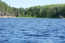
I have a 5 minute video of yesterdays rain, which lasted a half hour. Quite the storm and badly needed up north for sure. They seemed to get more rain than lightning that time so perhaps that will drop the risk a bit. Most of the fires along the Bloodvein are either out or under control as well. We shall see if they update the fire map tomorrow if it improved.

Biggest problem we have is smoke blanketing the area from Saskatchewan fires. We don't get to see the sun at all, just a haze down the the ground. Hot summer too, 99F yesterday with the humidex.
 
This spring we flew into Kawaseecheewonk Lake and took time to walk the Sakakoneckum portage out to the Bloodvein River. Walking back from the Bloodvein river I noted that the first 20 minutes were pretty good trail. It does dip into the bog for no reason in some spots. After that 20 minutes it enters the wettest part for another 20 minutes. This is really nasty at first and then is just nasty. At a total time of 40 minutes from the Bloodvein it enters solid ground in mature forest for another 20 minutes. As you near the north end of the portage it is possible to stay high above the marsh until you are out to good water. It is a very steep descent on dirt switchbacks to get down to the water. Lowering canoes with a rope would be a good idea and better than using the lower portage trail in the bog. Note that we were not carrying packs when 60 minutes got us across the portage.

Having been there and now looking at the satellite images it is very evident that the worst part of that portage could be rerouted on better ground. I plan on using the portage in a few weeks and will spend some time with the GPS and see if I can stay east of all the nasty trail and stay on better ground until picking up the portage section in the mature forest on the north end.
 
Last edited:
I spent 19 days in Atikaki roaming around and spent some time finding a dry passage through the middle of the Sakakoneekum Portage. This is a link to my trip report with access to the gpx file and a link to a G4 map with my info overlayed. The info can be used to access the rivers to the north but also put together loop trips in the area.

http://www.myccr.com/canoeroutes/atikaki-routes-leyond-pigeon-etc
A fire in 2018 burned the midsection of the dry upland option for this portage. The dry highground option is now impassable until a chainsaw cuts all the fallen timber in the burned section. The wet swampy section is being used and once across that the rest of the portage is clear all the way to Kawassacheewonk Lake.
 
Back
Top