8/20 - 8/24/2012 My girlfriend Judi and I spent 5 days poking around part of the 5 Ponds Wilderness area last week. Our plan was to set up base camp and do day trips to various lakes and ponds in the area.
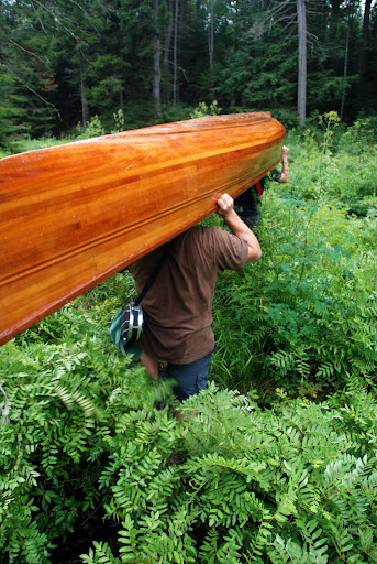
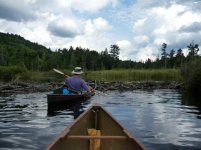
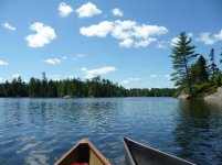
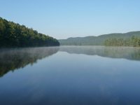
Day 1 - Arrived in Stillwater a little later than we wished (what else is new), Parked, loaded up the boats and said farewell to civilization for 5 days, starting with a 5 mile paddle half way across the Stillwater Reservoir. We stopped half way on a sandy beach to look back at our progress and the placid waters of the reservoir, then it was on to Trout Pond to access the first carry of about a mile to Salmon Lake to a bit of a rocky put in. Across Salmon Lake and up the inlet towards Witchhopple Lake and over a half dozen beaver dams, barely substantial enough to stand on, but big enough to have to get out and drag the boat across. From there an short but steep bushwhack/carry to the trail and a 3/4 mile carry along the trail to Witchhopple Lake that was to be our base camp for the week.
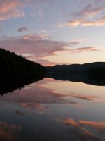
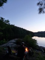
Day 2 - We decided to recover from the first day's exertions by doing a quick bushwhack to nearby Little Rock Pond, one of the nicest bodies of water I've been on. We spent the day exploring the fiord like bays and rocky islands. The highlight of my day was finding the unmarked portage trail making the trip back to camp much more enjoyable than the hobble bush surfing we did to get to Little Rock. Sunsets each night and misty mornings were the norm this trip.
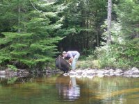
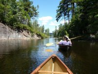
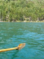
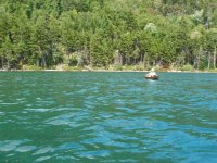
Day 3 - Today was to be a pretty big day for us and we set our sights on Crooked Lake via Clear Lake and Summit Pond. This excursion starts with a paddle across Witchhopple Lake and a 2 mile carry uphill to the end of the Red Horse Trail at Clear Pond. Clear Pond is an amazing turquoise blue that has to be experienced to be appreciated, but I have included a couple of pictures. I screwed up and didn't find the "carry" (read, unmarked, uncleared trail) and we struggled through some steep blow down and thick going to get to Summit Pond. I did successfully locate the "carry" from Summit Pond to Crooked Lake that I had traveled 3 or 4 years ago on a 6 day solo trip in the area, but it had not been maintained since. The old blazes on the trees were the only indication that there may have once been a trail here and after our struggle to get to Summit Pond, we conceded and did not make Crooked Lake on this trip. Beaten we made our way back to base camp to lick our wounds and watch another amazing sunset.
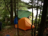
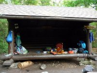
Day 4 - Upon listening to the weather forecast we decided that we would decamp that afternoon and move to a leanto back down on the reservoir so as to get an early start before the winds of the day picked up on the long paddle back the next day. In the morning Judi spent a leisurely morning at camp and I headed to Beaverdam Pond for a quick trip. In the afternoon we set out to make our way back to the reservoir.
Day 5 - After spending a comparatively luxurious evening and night at the leanto (Judi's first experience with leanto living) with an actual picnic table and outhouse we got up the next morning refreshed and ready for the 5 mile paddle back to the car. After an uneventful journey across the reservoir, the Molson's we left in a triple insulated cooler, while not cold, were a cool and sweet reward.
A wonderful trip where we saw no other soul from the time we left the reservoir until we returned. Judi did great as it is not easy to be 5'2", bushwhacking through 4' high hobblebush following a 6' tall guy with legs as long as mine.
Day 1 - Arrived in Stillwater a little later than we wished (what else is new), Parked, loaded up the boats and said farewell to civilization for 5 days, starting with a 5 mile paddle half way across the Stillwater Reservoir. We stopped half way on a sandy beach to look back at our progress and the placid waters of the reservoir, then it was on to Trout Pond to access the first carry of about a mile to Salmon Lake to a bit of a rocky put in. Across Salmon Lake and up the inlet towards Witchhopple Lake and over a half dozen beaver dams, barely substantial enough to stand on, but big enough to have to get out and drag the boat across. From there an short but steep bushwhack/carry to the trail and a 3/4 mile carry along the trail to Witchhopple Lake that was to be our base camp for the week.
Day 2 - We decided to recover from the first day's exertions by doing a quick bushwhack to nearby Little Rock Pond, one of the nicest bodies of water I've been on. We spent the day exploring the fiord like bays and rocky islands. The highlight of my day was finding the unmarked portage trail making the trip back to camp much more enjoyable than the hobble bush surfing we did to get to Little Rock. Sunsets each night and misty mornings were the norm this trip.
Day 3 - Today was to be a pretty big day for us and we set our sights on Crooked Lake via Clear Lake and Summit Pond. This excursion starts with a paddle across Witchhopple Lake and a 2 mile carry uphill to the end of the Red Horse Trail at Clear Pond. Clear Pond is an amazing turquoise blue that has to be experienced to be appreciated, but I have included a couple of pictures. I screwed up and didn't find the "carry" (read, unmarked, uncleared trail) and we struggled through some steep blow down and thick going to get to Summit Pond. I did successfully locate the "carry" from Summit Pond to Crooked Lake that I had traveled 3 or 4 years ago on a 6 day solo trip in the area, but it had not been maintained since. The old blazes on the trees were the only indication that there may have once been a trail here and after our struggle to get to Summit Pond, we conceded and did not make Crooked Lake on this trip. Beaten we made our way back to base camp to lick our wounds and watch another amazing sunset.
Day 4 - Upon listening to the weather forecast we decided that we would decamp that afternoon and move to a leanto back down on the reservoir so as to get an early start before the winds of the day picked up on the long paddle back the next day. In the morning Judi spent a leisurely morning at camp and I headed to Beaverdam Pond for a quick trip. In the afternoon we set out to make our way back to the reservoir.
Day 5 - After spending a comparatively luxurious evening and night at the leanto (Judi's first experience with leanto living) with an actual picnic table and outhouse we got up the next morning refreshed and ready for the 5 mile paddle back to the car. After an uneventful journey across the reservoir, the Molson's we left in a triple insulated cooler, while not cold, were a cool and sweet reward.
A wonderful trip where we saw no other soul from the time we left the reservoir until we returned. Judi did great as it is not easy to be 5'2", bushwhacking through 4' high hobblebush following a 6' tall guy with legs as long as mine.
Attachments
-
 378184_10150995457506626_1162991961_n.jpg99.2 KB · Views: 5
 -
 293010_10150995458236626_916684062_n.jpg94.2 KB · Views: 4
 -
 303648_10150995460181626_469974411_n.jpg97.4 KB · Views: 6
 -
 294395_10150995461706626_1192842670_n.jpg43.4 KB · Views: 4
 -
 580027_10150995462591626_271964359_n.jpg92.6 KB · Views: 6
 -
 284780_10150995463126626_854463207_n.jpg97.6 KB · Views: 6
 -
 523305_10150995464326626_98782053_n.jpg97.5 KB · Views: 6
 -
 561729_10150995468046626_178537953_n.jpg38.7 KB · Views: 5
 -
 582599_10150995467096626_430744675_n.jpg98.5 KB · Views: 3
 -
 527096_10150995467446626_511906006_n.jpg98.8 KB · Views: 4
 -
 10501_10150995465811626_1067327909_n.jpg97.3 KB · Views: 2
 -
 221970_10150995468726626_631388534_n.jpg94.8 KB · Views: 4
")