- Joined
- Aug 10, 2018
- Messages
- 2,121
- Reaction score
- 7,098
I'm not sure if you carry a plb or not but I'll include this on Tony's thread in case someone else is struggling with finding / making good maps:
I've been working on putting together some maps for Wabakimi next summer as I've been less than enamored with what I've been able to find.
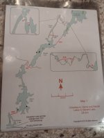
The maps available through wabakimimaps.com are reasonably detailed given the scale but it kinda freaks me out to see the outline of the water on a plain white sheet of paper and the scale is such that I've got 2-3 days of travel on the first map alone. (maybe not a bad thing but...)
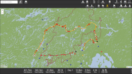
Looking on paddleplanner.com, I can map out the route also but I noticed that there were differences between the two as to where portages were located (both are merely approximations & I'll have to find them) as well as where campsites could be found.
I really do like that it gives estimated travel times and can be set to single or double carries and paddling speed is adjustable. The maps are printable w/ paid subscription but there is no way to modify them to add additional information (or, at least, none that I could find)
Mem says that he used Garmin BaseCamp for the maps he's given me and it, apparently, works if you already have the maps but Garmin stopped supporting it nearly a decade ago. I could download the program but couldn't get maps. It did, however, get me thinking...
I carry an inReach and can mark waypoints, etc on it from the computer, my phone or the inReach itself. The map can also be displayed on the inReach (Explorer model so it's larger and has a screen) or on my smartphone via the Earthmate app.
I jumped on Garmin Explore (their computer-based version of the Earthmate app- no idea why they need 3 names but...). I added some additional display screens to the laptop so I could easily compare and started marking portage locations and campsites from both the wabakimi.com maps and paddleplanner. I could also zoom Garmin Explorer and compare to Google Earth images so I believe that I now have the route mapped out very well on the inReach.
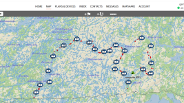
The clusters with numbers indicate multiple items in too-close proximity for the elevation and I marked campsites and portage locations from both sources as they were not always the same (if I can't find one, maybe I can find the other).
I also exaggerated the lines as shown in the middle portage below so I would know to look on river left or right for the takeout
Note: The western-most route from Whitewater Lake is my escape route. If I'm running out of time, food or energy, I can skip the second half & exit via Smoothrock Lake instead of going to Cliff Lake via the Raymond River as described in this thread.
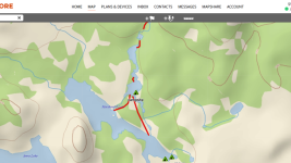
I could just go with this and I feel pretty sure that the wabakimi.com maps and the electronics would be sufficient. I do not like to trust electronics that much, however, so I am looking to print all of this info onto waterproof paper.
I can export data from the inReach so I opened up CalTopo and imported that data. My export options were KML or GPX and I chose KML to start. It transferred the map OK but left a lot of extraneous pins all over the place, most notably where I attempted to follow the portage shape.
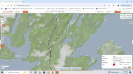
I couldn't find a way to get rid of the pins so I scrapped the map and started over importing the data as a GPX file. This worked better except that the portage lines for the last 2/3 of the trip are useless as they somehow got scattered randomly over the entire area.
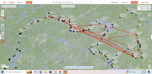
I'm not sure if anyone else has experienced this or not. If you have and there's an easy way to fix it, great. If not, I guess I've got all winter to edit and put the portage trails back where they belong.
I've been working on putting together some maps for Wabakimi next summer as I've been less than enamored with what I've been able to find.
The maps available through wabakimimaps.com are reasonably detailed given the scale but it kinda freaks me out to see the outline of the water on a plain white sheet of paper and the scale is such that I've got 2-3 days of travel on the first map alone. (maybe not a bad thing but...)

Looking on paddleplanner.com, I can map out the route also but I noticed that there were differences between the two as to where portages were located (both are merely approximations & I'll have to find them) as well as where campsites could be found.
I really do like that it gives estimated travel times and can be set to single or double carries and paddling speed is adjustable. The maps are printable w/ paid subscription but there is no way to modify them to add additional information (or, at least, none that I could find)

Mem says that he used Garmin BaseCamp for the maps he's given me and it, apparently, works if you already have the maps but Garmin stopped supporting it nearly a decade ago. I could download the program but couldn't get maps. It did, however, get me thinking...
I carry an inReach and can mark waypoints, etc on it from the computer, my phone or the inReach itself. The map can also be displayed on the inReach (Explorer model so it's larger and has a screen) or on my smartphone via the Earthmate app.
I jumped on Garmin Explore (their computer-based version of the Earthmate app- no idea why they need 3 names but...). I added some additional display screens to the laptop so I could easily compare and started marking portage locations and campsites from both the wabakimi.com maps and paddleplanner. I could also zoom Garmin Explorer and compare to Google Earth images so I believe that I now have the route mapped out very well on the inReach.

The clusters with numbers indicate multiple items in too-close proximity for the elevation and I marked campsites and portage locations from both sources as they were not always the same (if I can't find one, maybe I can find the other).
I also exaggerated the lines as shown in the middle portage below so I would know to look on river left or right for the takeout
Note: The western-most route from Whitewater Lake is my escape route. If I'm running out of time, food or energy, I can skip the second half & exit via Smoothrock Lake instead of going to Cliff Lake via the Raymond River as described in this thread.

I could just go with this and I feel pretty sure that the wabakimi.com maps and the electronics would be sufficient. I do not like to trust electronics that much, however, so I am looking to print all of this info onto waterproof paper.
I can export data from the inReach so I opened up CalTopo and imported that data. My export options were KML or GPX and I chose KML to start. It transferred the map OK but left a lot of extraneous pins all over the place, most notably where I attempted to follow the portage shape.

I couldn't find a way to get rid of the pins so I scrapped the map and started over importing the data as a GPX file. This worked better except that the portage lines for the last 2/3 of the trip are useless as they somehow got scattered randomly over the entire area.

I'm not sure if anyone else has experienced this or not. If you have and there's an easy way to fix it, great. If not, I guess I've got all winter to edit and put the portage trails back where they belong.
