A group of four of us just returned from a rather leisurely trip around the Whitney Wilderness loop in the Adirondacks. In spite of often less than ideal weather conditions, a wonderful time was had. Our group consisted of my 74 year old father in law, our 59 year old female friend recovering swimmingly from a back injury, my wife and me (mid 40's). My wife and I are avid wilderness travelers, expert backpackers and frequent canoe trippers with recent week long trips to Boundary Waters, Killarney, Algonquin and a different Adirondacks trip under our belts. My wife and I are also runners. I just completed a marathon in the last couple of months. I mention those items in order to put our experience in perspective; we aren't new to wilderness travel and have a level of fitness that allows us to take on hard, long days.
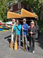
We spent the Friday evening before our trip's beginning (September 23) at Selkirk Shores State Park on Lake Ontario in order to split the drive from Cleveland, OH a bit. Saturday morning, we completed the drive on to Saranac Lake and picked up our rented kevlar 16.5 Wenonah boats from Adirondack Lakes and Trails Outfitters. I've had wonderful experiences renting and obtaining trip advice from this outfitter and I heartily recommend their services. We then drove on to the very full parking lot at DEC Little Tupper Lake Headquarters. I think we filled the final parking spot. Two groups were loading canoes on the beach. As I signed the register, it was clear that the vast majority of these folks were staying on Little Tupper Lake. This suspicion would be proved during the course of our trip. We loaded up and hit the water about 2:15 PM under clear, but breezy skies at about 62 degrees.
DAY 1
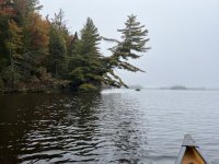
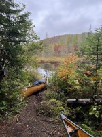
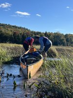
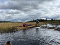
The NNW breeze kept us hugging the north shoreline of the lake. Campsites on LTL appeared to be full. It was a gorgeous day to paddle. The waves never threatened to break over the gunnels, but we remained cautious nevertheless and used the wind shadow of the island guarding the lake inlet to secure safer passage traversing the lake. Up the inlet we went pulling over two beaver dams along the way. We spotted some loons, a couple of eagles and great blue herons on the trip over. The river sites, 23 and 24, were unoccupied; but I wanted to get a portage, however short, under the belts of this crew. The portage over to Rock Pond is only a couple hundred yards, but my wife and I carried it three times. We had some work to do with the rest of our crew. In their defense, our packs were HEAVY with 7 nights worth of food, fuel and a few spirits. We made campsite 25 by 5:15 PM. It appeared one other party occupied the pond on the island. Skies remained clear through the evening as temps dropped into the low 40's. We ate our dinners, shared a couple bottles of wine (to lighten the loads!) and did a bit of fishing. I reeled in a 14" bass from shore. The stars were incredible, we spotted numerous meteorites, had a small ambiance fire and all dropped off to bed by 11:00. It was a grand first day.
DAY 2
Up about 6:30 AM, we ate a leisurely breakfast, with our hot beverages and packed up our shelters. A word on gear here: We carried our technical backpacks that we use in the mountains and packed gear inside in waterproof stuff sacks. I made this decision based on our heavy starting weights and the crew we had. This decision was a good one. Portage packs just don't carry as comfortably with a load. I chose to bring my MSR Dragonfly mountaineering stove that runs on white gas due to it's reliability and efficiency in the cooler temps. I carried 64 oz. of fuel to start and would use all but 8 oz as we cooked meals for 4, made generous numbers of hot drinks and even a few hot water bottles for the crew on cooler nights. My wife and I shared a Big Agnes Copper Spur UL 3. The other two had solo tents including a Big Agnes Copper Spur UL 2 which is an incredibly light and weather worthy shelter. We also carried a Noah's Tarp 12 which was integral with the coming weather. It comfortably shelters 4 with a running stove and food strewn about. I also had a waterproof Patagonia bag to carry excess food. This bag carried two canisters that did not fit in packs of our companions. As the trip went on, we moved gear into these food cans and they went into the packs. The Patagonia bag was empty by day 5. We had three fishing rods and five paddles between us.
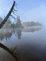
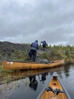
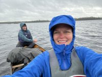
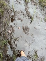
We were off to a bit of a late start- about 9:45. We made the short paddle over to our first significant carry over to Hardigan Pond. Clouds were forming, but temps were still in the 60's. Prior to kicking off the carry, I even took a short swim. Everyone else took off ahead of me with whatever gear they could carry. I caught them at the first beaver dam traverse. There were three of these and other boggy terrain that caused some challenges. In some places, we sunk above our knee in mud. There was just no avoiding it. It began to rain about halfway across and this rain became fairly heavy as temps dropped. I carried my HEAVY pack and a canoe for most of the portage and then went back to retrieve the Patagonia bag and second boat. My wife and I hopscotched the gear the rest of the way to Hardigan Pond. By the time we got all the gear there, it was raining hard and it was lunchtime. We pitched the tarp and took a long lunch out of the heaviest of the rain. It was so nice to sit dry and snug under the tarp to eat. Finally, about 2:30, we packed up and hit the water in a drizzle. We made the paddle across Hardigan Pond. It was beautiful in this weather. I'd like to pause here to thank Barry Rains. His report on this loop from last fall was integral at this, and many other stages. We made directly for the carry trail and made the short, easy carry over to the Salmon Lake outlet. The outlet down to Little Salmon Lake was a beautiful paddle made a bit slower by a number of pulls over beaver dams. All of this was accomplished in a steady drizzle, temps in upper 40's. It was about 5:30 when we settled on the primitive site at the NW corner of Little Salmon lake right at the carry. Initially, we had concerns about the comfort this site would afford but, as we settled in, it worked very nicely for our three tents and tarp. We set up in the rain and retreated under the tarp for a long dinner and hot drinks to chase the damp out. The rain became heavy in the evening as we drifted off to our tents by around 9:30. No fire tonight.
DAY 3
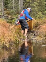
It rained on and off all night, but had largely stopped by morning. Tree rain kept us under the tarp for breakfast where I made pancakes and we celebrated a birthday. I had carried a canoe across the portage the previous evening. This is a fairly easy portage accomplished mostly on good, dry trail. There is a sharp right turn just above a beautiful cascade on the outlet that can be easily missed, as a member of our crew can attest to. We made the carry and paddled across Lilypad Pond, another beautiful little body of water, before 10:00. The put in and take out of Lilypad Pond must be waded in mud that is sometimes mid thigh deep.
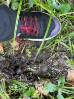
This brings about another note on gear: We all decided on trail runners/hiking shoes and a pair of technical sandals. I used my sandals where deep mud was present. My heavyweight Tevas offer enough support to carry gear and boats for stretches of a couple of miles with no damage. I managed to keep my shoes mostly dry and wore these for most of the carries. The Tevas would be my camp shoe with a waterproof sock on my foot. My father in law had a pretty good setup doing most of his paddling in Tevas with a neoprene sock over smartwool socks. This made the pulls over beaver dams much simpler.
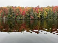
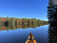
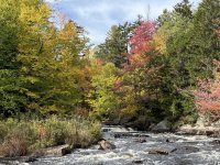
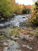
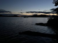
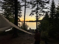
Completing the paddle across Lilypad, we then made the carry over to Shingle Shanty Brook. Rain had come again and it rained heavily at times. But then it cleared and we actually had some sun. The clearing brought cooler temps and some breeze as we made the incredibly winding paddle down the brook. There are a few beaver dams to clear in this section and the paddle is MUCH longer than it appear on the map as the brook winds along. We had the time though and really enjoyed the brook paddle. The colors were breathtaking. It seemed that autumn colors were rounding into peak shape. We hit Lake Lila and noted some white caps. We hugged the shore of the widening brook catching as much wind shadow as possible and then headed directly for Spruce Island. We made the island by 1:00 and had thoughts of stopping for lunch. To our shock, site 21 on the island was occupied. As far as we could tell, these were the only other humans on the lake. So, we paddled north and made a short open water traverse over to site 4. Our initial thoughts were to eat lunch here. However, as we landed, the skies opened. We pitched the tarp, ate lunch and the rain continued. We made the decision to stay and went about setting up camp. About 4:30, the rain stopped. We paddled around the corner and did some fishing landing a few smallmouth. We also gathered a bit of shoreline wood. We had our usual leisurely dinner and small ambiance fire. It was much cooler now. I think the temps got down to around 40. The skies cleared beautifully and we spotted all the constellations over the lake, meteorites and the mysterious and startling SpaceX satellite string. We didn't know what that was until the conclusion of the trip. It created a lot of conversation and theorizing in the coming days.
We spent the Friday evening before our trip's beginning (September 23) at Selkirk Shores State Park on Lake Ontario in order to split the drive from Cleveland, OH a bit. Saturday morning, we completed the drive on to Saranac Lake and picked up our rented kevlar 16.5 Wenonah boats from Adirondack Lakes and Trails Outfitters. I've had wonderful experiences renting and obtaining trip advice from this outfitter and I heartily recommend their services. We then drove on to the very full parking lot at DEC Little Tupper Lake Headquarters. I think we filled the final parking spot. Two groups were loading canoes on the beach. As I signed the register, it was clear that the vast majority of these folks were staying on Little Tupper Lake. This suspicion would be proved during the course of our trip. We loaded up and hit the water about 2:15 PM under clear, but breezy skies at about 62 degrees.
DAY 1
The NNW breeze kept us hugging the north shoreline of the lake. Campsites on LTL appeared to be full. It was a gorgeous day to paddle. The waves never threatened to break over the gunnels, but we remained cautious nevertheless and used the wind shadow of the island guarding the lake inlet to secure safer passage traversing the lake. Up the inlet we went pulling over two beaver dams along the way. We spotted some loons, a couple of eagles and great blue herons on the trip over. The river sites, 23 and 24, were unoccupied; but I wanted to get a portage, however short, under the belts of this crew. The portage over to Rock Pond is only a couple hundred yards, but my wife and I carried it three times. We had some work to do with the rest of our crew. In their defense, our packs were HEAVY with 7 nights worth of food, fuel and a few spirits. We made campsite 25 by 5:15 PM. It appeared one other party occupied the pond on the island. Skies remained clear through the evening as temps dropped into the low 40's. We ate our dinners, shared a couple bottles of wine (to lighten the loads!) and did a bit of fishing. I reeled in a 14" bass from shore. The stars were incredible, we spotted numerous meteorites, had a small ambiance fire and all dropped off to bed by 11:00. It was a grand first day.
DAY 2
Up about 6:30 AM, we ate a leisurely breakfast, with our hot beverages and packed up our shelters. A word on gear here: We carried our technical backpacks that we use in the mountains and packed gear inside in waterproof stuff sacks. I made this decision based on our heavy starting weights and the crew we had. This decision was a good one. Portage packs just don't carry as comfortably with a load. I chose to bring my MSR Dragonfly mountaineering stove that runs on white gas due to it's reliability and efficiency in the cooler temps. I carried 64 oz. of fuel to start and would use all but 8 oz as we cooked meals for 4, made generous numbers of hot drinks and even a few hot water bottles for the crew on cooler nights. My wife and I shared a Big Agnes Copper Spur UL 3. The other two had solo tents including a Big Agnes Copper Spur UL 2 which is an incredibly light and weather worthy shelter. We also carried a Noah's Tarp 12 which was integral with the coming weather. It comfortably shelters 4 with a running stove and food strewn about. I also had a waterproof Patagonia bag to carry excess food. This bag carried two canisters that did not fit in packs of our companions. As the trip went on, we moved gear into these food cans and they went into the packs. The Patagonia bag was empty by day 5. We had three fishing rods and five paddles between us.
We were off to a bit of a late start- about 9:45. We made the short paddle over to our first significant carry over to Hardigan Pond. Clouds were forming, but temps were still in the 60's. Prior to kicking off the carry, I even took a short swim. Everyone else took off ahead of me with whatever gear they could carry. I caught them at the first beaver dam traverse. There were three of these and other boggy terrain that caused some challenges. In some places, we sunk above our knee in mud. There was just no avoiding it. It began to rain about halfway across and this rain became fairly heavy as temps dropped. I carried my HEAVY pack and a canoe for most of the portage and then went back to retrieve the Patagonia bag and second boat. My wife and I hopscotched the gear the rest of the way to Hardigan Pond. By the time we got all the gear there, it was raining hard and it was lunchtime. We pitched the tarp and took a long lunch out of the heaviest of the rain. It was so nice to sit dry and snug under the tarp to eat. Finally, about 2:30, we packed up and hit the water in a drizzle. We made the paddle across Hardigan Pond. It was beautiful in this weather. I'd like to pause here to thank Barry Rains. His report on this loop from last fall was integral at this, and many other stages. We made directly for the carry trail and made the short, easy carry over to the Salmon Lake outlet. The outlet down to Little Salmon Lake was a beautiful paddle made a bit slower by a number of pulls over beaver dams. All of this was accomplished in a steady drizzle, temps in upper 40's. It was about 5:30 when we settled on the primitive site at the NW corner of Little Salmon lake right at the carry. Initially, we had concerns about the comfort this site would afford but, as we settled in, it worked very nicely for our three tents and tarp. We set up in the rain and retreated under the tarp for a long dinner and hot drinks to chase the damp out. The rain became heavy in the evening as we drifted off to our tents by around 9:30. No fire tonight.
DAY 3
It rained on and off all night, but had largely stopped by morning. Tree rain kept us under the tarp for breakfast where I made pancakes and we celebrated a birthday. I had carried a canoe across the portage the previous evening. This is a fairly easy portage accomplished mostly on good, dry trail. There is a sharp right turn just above a beautiful cascade on the outlet that can be easily missed, as a member of our crew can attest to. We made the carry and paddled across Lilypad Pond, another beautiful little body of water, before 10:00. The put in and take out of Lilypad Pond must be waded in mud that is sometimes mid thigh deep.
This brings about another note on gear: We all decided on trail runners/hiking shoes and a pair of technical sandals. I used my sandals where deep mud was present. My heavyweight Tevas offer enough support to carry gear and boats for stretches of a couple of miles with no damage. I managed to keep my shoes mostly dry and wore these for most of the carries. The Tevas would be my camp shoe with a waterproof sock on my foot. My father in law had a pretty good setup doing most of his paddling in Tevas with a neoprene sock over smartwool socks. This made the pulls over beaver dams much simpler.
Completing the paddle across Lilypad, we then made the carry over to Shingle Shanty Brook. Rain had come again and it rained heavily at times. But then it cleared and we actually had some sun. The clearing brought cooler temps and some breeze as we made the incredibly winding paddle down the brook. There are a few beaver dams to clear in this section and the paddle is MUCH longer than it appear on the map as the brook winds along. We had the time though and really enjoyed the brook paddle. The colors were breathtaking. It seemed that autumn colors were rounding into peak shape. We hit Lake Lila and noted some white caps. We hugged the shore of the widening brook catching as much wind shadow as possible and then headed directly for Spruce Island. We made the island by 1:00 and had thoughts of stopping for lunch. To our shock, site 21 on the island was occupied. As far as we could tell, these were the only other humans on the lake. So, we paddled north and made a short open water traverse over to site 4. Our initial thoughts were to eat lunch here. However, as we landed, the skies opened. We pitched the tarp, ate lunch and the rain continued. We made the decision to stay and went about setting up camp. About 4:30, the rain stopped. We paddled around the corner and did some fishing landing a few smallmouth. We also gathered a bit of shoreline wood. We had our usual leisurely dinner and small ambiance fire. It was much cooler now. I think the temps got down to around 40. The skies cleared beautifully and we spotted all the constellations over the lake, meteorites and the mysterious and startling SpaceX satellite string. We didn't know what that was until the conclusion of the trip. It created a lot of conversation and theorizing in the coming days.