• Happy Peace Officers Memorial Day! 👮🏽‍♂️👮‍♀️

Fire in WCPP

Joined
Aug 22, 2013
Messages
924
Reaction score
57
Location
Red Lake, Ontario
I am hesitant to post this but it is worth mentioning for anybody planning a trip up this way this year. You should almost certainly have an alternative plan. Wind over the weekend caused the fire to spread and it is now encompassing so much of the park it is astounding. Think Carroll Lk to Optic and south. Leano is closed as the fires is almost as far as Bunny Lk.

In the years to come it sure will make for some interesting paddles.
 
That being what we call the Beresford Fire, or in your neck of the woods, Red Lake 003. I saw on Sunday it was considered "Being Held" then yesterday it was again out of control. That is one massive fire for sure and could burn for months. Are they even considering it could make it's way to Red Lake?
 
Oh my - that is some of my favorite country - I was thinking of heading in that direction end of June ... I have been there when large 50,000 hector plus fires burned out of control ... dang!

Thanks for the post Red ... sad news.

Bob.
 
Really sad, although I know that these fires are part of the natural cycle, the thought that I an unlikely to see mature forest in that area again in my lifetime is very sobering. This also shows the fallacy of parks to protect species. If the area inside the park is burned animals like woodland caribou will relocate to other mature forest. If that forest is outside the park and is scheduled for cutting what then?

This website has an interactive map that lets you see the details of a particular fire and the fire perimeter.

http://cwfis.cfs.nrcan.gc.ca/interactive-map
 
The perimeter of that fire is somewhat incomplete on that map, the fire did burn all the way up to Obukowin on the south and east sides and the bottom of Carroll Lake as well. I think the hole in the middle was part of the original burn when it started 3 weeks ago. All the ports from Siderock into Crystal are gone, but it didn't get far enough to burn the Mothers.

Consider how much wildlife didn't get out of the way as well, could be a significant amount of loss.

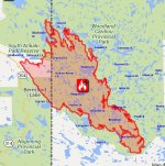
From the WCPP official site.

~~ Fire Red 3 that is burning in the southern section of Woodland Caribou Provincial Park is still out of control but suppression action is being undertaken to protect structural values, property and important wildlife habitat. Recent developments have seen an escape of the fire in two areas. North of Dragon Lake to Mexican Hat Lake and Optic Lake and North of Carroll Lake towards Walking Stick Lake. Please note below the additional access point closures that have been added.

The Iriam Lake Road is being closed May 23 2016 until further notice. We hope this will be only be required for the short term.

The fire size is now approximately 70,000 hectares.

Subject to Section 33(1), Provincial Parks and Conservation Reserves Act (2006) entry to Woodland Caribou Provincial Park is prohibited at the following access points;

Eagle Lake
Garner Lake
Crystal Lake
Carroll Lake
Obukowin Lake
Jan Lake
Leano Lake
Onnie Lake
Johnson Lake

Travel on canoe routes in the vicinity of Fire 3 while in the interior of Woodland Caribou Provincial Park is also prohibited. Please contact the park office for a copy of a map depicting this area. This decision has been made with the safety of visitors to the area in mind. You can reach us at woodland.caribou.mnr@ontario.ca or
call_skype_logo.png
807 727 1329.

Even though it has recently been cool and damp, the bush is very dry. Soils are thin in Woodland Caribou and it takes little time for vegetation to dry out after precipitation. Accentuating this situation is the Snowdown Event of 2012 and the sawyer beetle damage throughout the area. Please use the highest level of caution when recreating and travelling in the bush.
 
Last edited:
The map I am looking at right now lists the fire at 75560 ha and is dated May 17. I saw a map last night that showed the "escapes" north and surely this is getting closer to 100000.
 
Yes that is a sobering idea that there will be no mature forest in that area in the time that I have left. I can always go north but that entails a longer drive. Unfortunately it appears that my canoe tripping days are fast coming to an end. We were out for two days and it basically pounded me into the ground. So it looks like weekenders and day trips for me now. Better than nothing but far from what I was hoping for.
 
On the bright side though, this should thin out the tick population. Burn baby burn.
 
Sure too bad to see this. I haven't been to the south end of the park and have been wanting to check that area out one of these years.

Like others have said it's a natural part of the process but it's still hard to take. Partly because so few areas are actually protected from logging and development. It hurts to have such a large chunk of our small piece of the pie "taken away".

Alan
 
I am quite surprised there isn't more chatter online about this fire but I guess it's a testament to how few folks actually paddle WCPP.

WCPP is my favorite area to paddle and has been for many years already. The fact that the easiest and cheapest access points are all getting destroyed is going to cause issues for folks like me for many years to come. For example, even the accesses from the Manitoba side are burnt. Apparently even if the trails get cleared, they will suffer from blowdown issues for many years to come. I'm especially bummed because I had a fantastic 2 week fly-in, paddle-out trip planned with my 15 y.o. son. We might still be fine with a fly-out option but no guarantees this fire is even out by the summer. :(

I do realize it's a natural cycle, but selfishly it still sucks.
 
Vern, you could still access Obukowin to Carroll from the Mothers as they survived so far. Also through the Bird and Snowshoe Lakes, it hasn't gotten down that far yet. The Siderock to Crystal and from Garner Lake did burn well though.
 
Is the fire out in that area though? That is my backup plan but I thought that access was also closed and currently still burning?
 
I guess it depends on when your trip is. Pretty much all accesses on the East, South and West are presently closed as is the Iriam Road Loop. It certainly could be a while before these areas re-open. The Park is also prohibiting interior travel in areas anywhere near the fire.

On the plus side, all this rain has to help in keeping the fire from spreading more.
 
No Title

Tried to map the fire boundaries a bit for reference.
 

Attachments

  • photo4624.jpg
    photo4624.jpg
    126.8 KB · Views: 0
Last edited:
Good map! Where did you get your data?

Down near Dragon lake there is a long finger extending up towards Optic just a few km south of it. There is also a long skinny tendril that runs north near Donald or carol but I'm not sure where about a that leg terminates
 
Back
Top