• Happy National Blueberry Pie Day! 🫐🥧

14 Days on the Upper Thelon River

I find this article disappointing and inaccurate. First of all, they did not paddle the Upper Thelon, which has many rapids and multiple portages, including the 5 km (3 mile) portage around the Thelon Canyon. The article says there were no portages. Wrong. The article mentions Alex Hall, who led trips that often began below the Canyon. I call that the Middle Thelon, which is easy and straight forward. Suitable for beginners. But the article doesn’t say where they put in. Why not? Such missing information is necessary for an informed article.

Finally, if it’s so easy, why was there a capsize, which I consider unacceptable on cold isolated rivers. Particularly on a guided trip. I would not recommend guides who allowed this to happen.
 
Finally, if it’s so easy, why was there a capsize, which I consider unacceptable on cold isolated rivers. Particularly on a guided trip. I would not recommend guides who allowed this to happen.

I think this is a bit harsh.

Anyone, especially novices, can capsize in rapids for a variety of reasons, and frequently capsize even on flat water. The two guides were split up among the novices in different canoes. The rapid was on a hugely wide river, which would be of no interest to me, and seemed to consist of three widely-spaced, river-wide ledges, over the course of 500 meters. I assume they didn't want to portage the 500 meters and that the group was likely looking forward to the experience of running the "big rapids" of the trip.

The four canoes were likely fairly far apart when running the ledges. Even if the guides knew the exact spots to run the ledges—which they may not have known because of hydrological changes due to varied water levels—things happen with a novice in the canoe. Even experienced paddlers can pick the wrong spot to run a ledge, or hit an unexpected curling wave, or a keeper hole, or submerged rock, or whatever, and capsize. I've dumped in class 1 rapids when not paying close enough attention even when I was a class 4 paddler.

I'm not sure how guides can prevent capsizes when a variety of different canoes are underway on different parts of the river. Sometimes stuff just happens. I've never touted myself as a guide, but I've organizationally led hundreds of whitewater day trips and on most of those I would take the lead position in running all the rapids on the best routes I could discern either from experience or scouting. But I had no control over how the less experienced paddlers behind me could execute, or would fail to execute, what they saw me do. Making mistakes is part of learning the sport.

Those huge flat sections between the three ledges on the Thelon seem like a reasonably safe place to have taken some risk and learn.
 
I think the northern Tundra rivers are harsh. The remoteness and cold water magnifies the effects of any mistake.

I agree with Pitt. Bad information is worse than no information. It happened to me this year on the Klamath River. We rowed a remote section in drift boats that was the easiest I could find. The river was high that everything was fast. Few people run this section and the guide books mentioned only one of the bridge abutments out of the 5 we ran across. It give people a false sense of security.
 
Not sure why a magazine would bother to print an article by a new guy with little canoe experience or, apparently, any back country travel - he got lazy and didn't seal the drybag with his sleeping bag? The article belongs in "House and Garden" or "Readers Digest".
 
Given the trip length of 200 km (193 on the Jackpine site), and the fact that they pass through Eyeberry Lake, it's clear that this trip must have started just below the last falls on the upper Thelon ( a few km above its junction with the Elk river) and ended above the Thelon Canyon.

I don't think Paddling Pitt was at all harsh. In late August in the Barrens, the water is cold. The article describes the weather leading up to the incident as the "coldest of the trip" - down to freezing at night. No wet or dry suits, gear not secured (one pack was found 20 km downstream), waterproofing not checked, no information on the rapids at prevailing water levels, a less than experienced group: all this, and they couldn't be bothered to scout?

I see this as a major error in judgement by the guides.

wjmc
 
(Thanks, wjmc. I should have known this, particularly since I also know of a group that flew in below the Elk River Falls. If one takes out just after Eyeberry Lake, not too many rapids and portages exist. I apologize for accusing the writer of not being on the Upper Thelon, which between Lynx Lake, where Kathleen and I began in 1993, has many rapids and portages before the confluence with the Hanbury River.

I believe the capsize in question likely occurred above the confluence with the Mary Francis River. Below is from our diaries. As you can see, we are always very cautious. Mistakes, particularly when all alone, can be serious.
)

We continued to travel fast, passing more mapped, submerged rocks, and I began to look forward to an early camp, perhaps 5:00 or maybe even 4:00 pm. The map suggested a back-eddy opposite the Mary Francis River that might provide a sandy beach.

By 2:00, the wind quickened, and the rocks sat defiantly above the water, flanked by ledges jutting out from both sides of the river. Scouting became necessary, and the constant vigilance inserted tension into what had been a lackadaisical day.

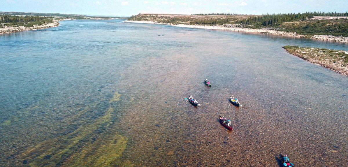
On most rivers we have run, the safest route generally exists on the inside bend, which usually has slower water flanked by an eddy. Outside bends stack the flowing water in larger, standing waves, and may have sweepers jutting out from undercut banks. On the Thelon, however, inside bends are often the least safe. The shallower water reveals more rocks, and ledges extend further from shore. The outside bend exhibits fewer rocks, and usually provides enough room to avoid the high standing waves.

Not always, however. As we approached the next bend, ledges obviously extended from both banks, nearly meeting in the middle. We beached, and scouted from a low ridge above the chute.

"Heck, all we need to do is line up, and hit the down-stream V."

"Those waves below the ledge are just haystacks."

"We can run this."

We ferried out, headed for the "V," and then noticed for the first time a large rock, hidden behind a flashing wave. We side-slipped right, perilously close to the ledge, avoided the rock, side-slipped left, and hit the "V."

"Oh, my God, these may be just haystacks, but they're awfully big." We braced with all our strength, hoping to exit upright. It seemed we were held in place by the standing waves, forever suspended in the brace position. Would we remain here until freeze-up, at which time we could walk across the haystacks to shore? Eventually we emerged from the white rollers, and congratulated ourselves for having taken the time to wear our spray skirts, stretched water-tight over the piping on the spray deck."

Thelon042 resize.jpg

Only two more ledges before the Mary Francis River and the anticipated white sand beach. We lifted over the first ledge, a short portage of 50 m.

Thelon043 resize.jpg

We avoided the second ledge by ferrying all the way across the river. At 6:45, a strong north wind blew directly towards us. Why does the wind always shift to meet us at the end of the day, no matter what direction we're travelling?

We arrived at the Mary Francis River at 7:30 pm, with four muskoxen visible on the far shore. The white sand beach of our visions and hopes had rudely metamorphosed into an expanse of large boulders. Too tired to continue, we fitted the tent between rocks as best we could, made a fire, and ate the last of the lake trout.

(Note: We did a lot of scouting, and some portaging. But we remained upright and dry.)
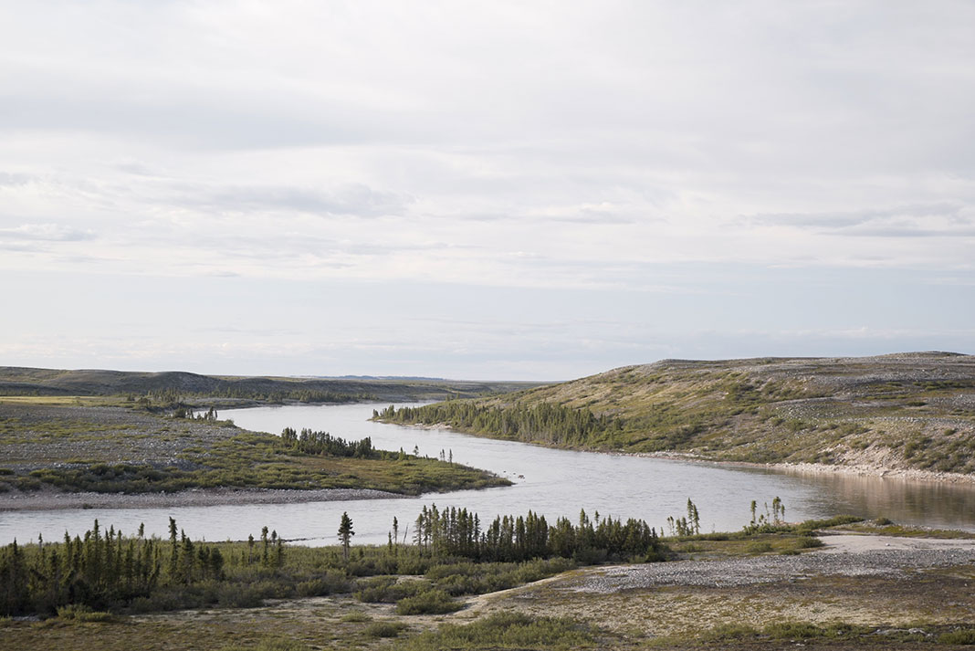
 
My criticism is of Michael's criticism that the guides "allowed" two capsizes to happen in a 200 kilometer trip.

The article says that they scouted some of the rapids, but boat scouted and discussed the easy-looking three-ledge rapid while rafted up. The late August water is described as "chilly". Lots of river boaters regularly paddle on snow pack or glacial waters that are barely above freezing. Ocean kayakers boat in cold oceans. Everyone capsizes now and then.

The author got his sleeping bag and clothes wet because he had become "complacent" about sealing his dry bag properly, not because he didn't have proper equipment or instruction. One guy lost a dry bag down river until found, obviously because he didn't tie-in the bag. Lots of whitewater trippers here claim they don't bother tying in floatable gear bags on pool-drop rapids.

From their extensive website, Jackpine Paddle, founded in 1973 as Canoe Arctic, seems to have a long history and and excellent reputation. Here is the Thelon River trip page with a map of the route:


I don't know if this is the "upper Thelon" or not, but that seems like a quibbling matter of relative adjectives. Where does the Upper Nile start, or upper New York State, upper latitudes, the upper class, or upper income. Different people define boundaries differently. (Why is the geographical area that used to be called the Near East now called the Middle East? What the heck happened to the Near East and where is it now!)

The Thelon River trip page says the Thelon is suitable for novices and that there are eight rapids on the route. It also says: "the Thelon the largest and most remote river in the Barren Lands, it’s also the easiest and safest to canoe. . . . the Thelon enjoys some of the best summer weather in North America, thanks to it’s dry, sunny climate in this deep interior location." Is this true? I don't personally know. I'd like to hear more from experienced Thelon trippers.

All opinions are welcome, but mine is that it is not cause to suggest that an outfitter is basically incompetent because there were two novice boater capsizes in an easy rapid in chilly water on a 200 km trip. I'd call that a successful and memorable experience.
 
Last edited:
Michael, I totally understand your feelings about capsizes being 'unacceptable' on remote rivers, which you've mentioned often. But it's also true that sometimes sh*t happens, even with plenty of experience and even (sometimes) while exercizing reasonable judgement. (I'm not saying that's the case in the article above.) But I have to imagine that you and Kathleen have had a few close calls over the years, circumstances in which the outcome could easily have gone quite differently despite your best efforts and best judgement?

Having said that, I agree that an 'expedition mentality' is critically important, especially in the far north and especially with only one canoe, which--like you and Kathleen--is how my wife and I tripped. I've portaged plenty of rapids that I would have run in other, more benign, circumstances (closer to home, closer to a take-out, or with more people/canoes around to help). As I've gotten older, and taken up solo tripping, this mentality has become even more paramount.

Thanks for those photos. Brings back good memories, though I'll freely admit that my swim through part of the Thelon canyon was a great lesson in poor judgment, from which I was lucky enough to live and learn :)

-tom
 
Glenn, It's fair to say that they paddled on the Upper Thelon; but I think most people knowing the the Thelon River would not say that they paddled the Upper Thelon. Image below illustrates that the Upper Thelon lies between the outlet of Lynx Lake, and the confluence with the Hanbury River. Relatively few paddlers put in at Lynx Lake because of the difficult rapids and long portages.

Thelon014 resized.jpg
 
Tom,

I have been worried only two times. The first was on the Thelon River. Bad judgement on our part. See below. Kathleen in italics.


By 4:00 pm we had covered 60 km. A cold drizzle began midday, and intensified in late afternoon. We were about 20 km and 3 hours from Baker Lake, riding a swift current, when we agreed to push on rather than camp one last night on the river. Good camping spots had not been evident along the high, soggy banks, and we were wetter than we'd been on the entire trip.

All day I had paddled with my white-water paddle, in case I suddenly needed to make forceful strokes. The fast water intimidated me, and I continually gazed ahead for evidence of rapids. On this very straight section of the Thelon, I was often fooled by the white horizon-line. In late afternoon, I again thought I saw white, frothing water; but, peering through my rain-stained glasses, I again discounted the potential threat.

We approached the 2-km S-bend that emptied into a wide, shallow section of the river just upstream from its delta that drains into Baker Lake. Suddenly the boils and whirlpools became larger, and decidedly uncomfortable.

"Why are these here now? I don't see any reason for them."

"I don't know."

"Do you see rapids down there?"

"No, do you?"

"I don't know. It looks a bit white, and I think I can hear rapids."

"It's probably just a tributary spilling over rocks. You know how loud they can sound."

"Yeah, that's right. Let's go."

We entered the right-trending portion of the S-bend and immediately wished we hadn't. Only then, and too late, we realized that the bend constricted the river into enormous waves. Standing waves nearly two metres high deflected off the left bank, and swirled toward us in an ominous series of whirlpools. Our only hope to avoid capsize would be to hold our boat steady in the circulating boils without being dragged across the eddy line into the powerful reversal-current. My body went completely ice cold. I felt I might not have the strength to make the necessary strokes. I called into the wind "God be with us. Please God, be with us."

"I'm scared."

"I don't like this either." We braced, heading right, toward river-centre, to escape the diagonal, curling tongues of green and white. My breathing came in short, staccato bursts. This looks bad.

Ahead, we could see the river channel bending back towards the left. The river surged toward this outside bend, and slammed into the cliff face. Our canoe sped toward the cliff, where the water piled up in 2.5-m-high standing waves. Adrenaline and fear fought for control of my body and mind. To continue right meant certain capsize. In silence, we struggled to reverse our direction. Kathleen drew left. I swept right. The canoe turned sluggishly toward the inside bend on river-left.

Still in silence, we powered diagonally across deep haystacks created by the current deflecting off the point around which the river narrowed and veered sharply left. Immediately beyond the point, a powerful reversal eddy re-entered the main current in a mountainous ridge of breaking, irregular waves.

"Oh God, oh God, I don't want to be here!" Too late, though.

"Oh, most terrible expletive!" Five weeks on the journey, and we're going to die three hours from Baker Lake. Most of all, though, I feared the humiliation of knowing what our fellow canoe club members in Vancouver would say about our self-inflicted demise: “They committed the worst sin of wilderness canoeing - - entering a blind canyon without scouting first. They should have known better.”

We braced against the waves as we guided the canoe toward the eddy line below the ridge of water. Struggling against the opposing currents, we alternately powered and braced to hold our parallel position between the dangerous reversal on our left and the impossible waves to our right. Fear continued to assault my being. Would we ever reach the end of this canyon?

Finally, the broad opening beyond the S-bend appeared. I think we're going to live! Fear had now sapped all my energy. I knew I couldn't paddle through another rapid. All I wanted was to get to shore, but the strong current of the wide Thelon continued flushing us down-river. From the map Michael knew the river soon opened up into its delta, and that we had already passed through the worst of the rapids. I hadn't studied this section of the map, and didn't know that we needed only to brace against the haystacks created by moving water emptying into the delta. I accepted Michael's advice, though, to keep paddling until we reached calm water.

The river ejected us through the gap, and we rode the dissipating haystacks to river-left, where we beached the canoe for a gorp break and the pleasure of standing on land. I felt genuinely pleased to be alive. That was the most scared I have ever been in my life.

Back in the boat, after a sausage and gorp snack, we rounded Hornet Point at 6:30 pm, and paddled easily toward the tight-clustered collection of buildings comprising Baker Lake.

Note: The Thelon was at very high water that year.
 
Last edited:
I think most people knowing the the Thelon River would not say that they paddled the Upper Thelon.

Haha, I really don't care about this point.

But . . .

I don't have to personally be a paddler of the Thelon to ask: What "people" would be more familiar with, and credible about, Thelon terminology than the one and only outfitter who has been running and guiding on it for 50 years—namely, Jackpine Paddle nee Canoe Arctic. They win.

As an example familiar to eastern whitewater boaters, the Youghiogheny River in Pennsylvania used to be terminologically categorized into the Lower Yough, Middle Yough, and 4-5 Upper Yough. There was more river above the Upper Yough but no one thought it was boatable. When it became regularly boated, it was called the Top Yough.

Similarly, the hardest part of the Moose River in New York was called the Lower Moose. Beyond that, the river was considered unboatable. When that part began to be regularly boated, it became known as the Bottom Moose.

Further perusing Jackpine's Upper Thelon page, they rate the whitewater as class 1. Running class 1 water with three other boats around is hardly risky and not dangerous if one dumps, with seven other people's clothing and tents available. The float plane flight is surely more dangerous, and the drive to Yellowknife is surely much more dangerous than the float plane flight.

Good discussion about a topic I thought would be a dead quail.
 
Image below illustrates that the Upper Thelon lies between the outlet of Lynx Lake, and the confluence with the Hanbury River

Okay, now I'm better oriented, but don't understand what are we debating. THIS SITE agrees that: "The Upper Thelon drops about 100 meters over a distance of some 200 kilometers from Lynx Lake to the junction of the Hanbury River." Since Eyeberry Lake is about 55% of the way down the Jackpine trip, that trip would seem to be entirely within the section known as the Upper Thelon. Surely, one can claim to have paddled the Upper X River even if not starting at the absolute source.

Thelon map.gif
 
Back
Top