What a Raquette!
We’ll, it’s late January and well into canoe-trip-planning season. I’m looking at a few routes that I’ve never done before, but also hoping to return, for the third year in a row, down the Lower Raquette River in the northern Adirondacks.
Not to be confused with the popular flatwater stretch upstream, between Long Lake and Tupper Lake, this stretch from Piercefield to Jamestown Falls is much quieter and much more entertaining with its numerous class II-III rapids and large, scenic waterfalls to break up the flatwater stretches. I think the rapids tend to keep the riff-raff out of this area because it’s in the local guidebook, yet seems to get very little traffic and it’s hard to find any trip reports or info on it. In fact, I feel a little guilty posting it here, but I trust this crowd to keep the secret close, or at least say hi if I bump into you there.
Last year, Patrick and I were able to talk our friend Brian into coming along for the ride after showing him some videos from the year before. Though it’s been awhile, in a kayak to boot, Brian has more whitewater experience than either of us, so he was a welcome addition to the crew. It’s always fun to have a competent paddler in the bow who’ll talk you into running that questionable line. He also proved to have excellent swimming skills that would come in handy.
Patrick… well, Patrick brought the comic relief and a cooler full of beer. Two essential skills to have on any self-respecting canoe trip.
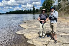
He and I had run this stretch the previous spring of 2021 at slightly higher water levels in technical whitewater solos, mostly because we didn’t know what we were getting into with a map rating the mandatory Moosehead rapid as a potential III+. This year we brought more tripping oriented boats to make the flats and afternoon headwinds more tolerable. Patrick in his RX Nova Craft Supernova and Brian and I in my Old Town Appalachian, they were definitely a better overall fit for this stretch and still capable enough for the majority of the whitewater.
We put in at the town beach just below the dam for two reasons. One, the portage around the north side of the dam sucks. It’s rough, steep, long enough and a terrible way to start a trip. Two, coming in on Dead Creek skips a long, fun, class II warm up rapid. I recommend dropping your boat and gear at the beach, parking at the public lot at Piercefield Flow on the east side of the Rt 3 bridge and walk 10 minutes back to the beach.
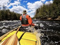
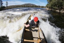
Finally on the water, we pass the last few houses and leave civilization behind as we round the first bend and the river instantly takes on a wilderness feel. The opening warmup rapid is pretty straightforward, read-and-run with the easiest line down center-right. If you’ve got a really dry boat and are looking for some spice, you could run the giant, 3-4’ wave train on river left as seen in this photo from our 2021 trip.
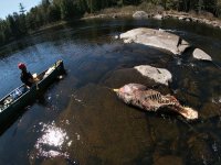
After about a mile of flatwater rounding the western side of Sol’s Island, we approach the top of Upper Sol’s rapid and notice a couple crows take flight from the middle of the river. After a quick scout from the portage trail on river left, we took a slight detour across the river to investigate. What we found was an adult moose that had apparently drowned due to a hoof entrapment!
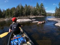
I’m no wildlife forensics expert, so it’s hard to say if it had fallen through the ice at some point over the winter, or if it was swept downstream during spring flows in an attempted crossing, but it was clearly not wearing a life jacket and that was most likely a contributing factor.
Upper Sol’s is really two rapids. The first part being a pretty easy class II right down the middle followed by short break in the action that gives you plenty of time to eddy-out river left and portage around the real Upper Sol’s, a tall, glassy surf wave followed by a 5-6’ drop into a sticky, riverwide souse hole.
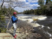
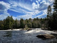
The map says this rapid is a III+ and Lower Sol’s is a class IV-V, but it’s really the other way around. After much deliberation, and portaging our gear, we decided we’d run a line down the far river right of Lower Sol’s, a solid III, but relatively short.
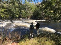
We found a weakness at the far right end of a riverwide ledge that dropped three feet into a big standing wave, but then had to instantly cut a hard left and ferry to river center to avoid another ledge directly below. The shock of the initial drop left me a little slow to start my pries, but Brian performed like clockwork as if this was his third lap of the day. We got over just in time but still greased over one rock buried in the exit waves.
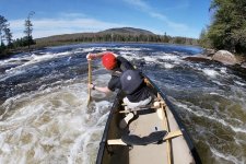
Patrick wasn’t as lucky. Maybe it was the difference between one paddle in the water and two. Maybe it was the aerated water that left his draw strokes ineffective, but he couldn’t get over fast enough to avoid the next ledge. However, he did an excellent job parallel parking his boat onto that ledge and calmly stepping out onto the rock in a manner that resembled a drift maneuver from the Fast and the Furious movies. Brian and I sitting in the eddy just below him thinking he was about to hand us the keys like we were a couple valets at the Waldorf Astoria.
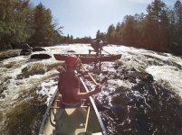
After playing in the waves for a couple more minutes, we paddled over to the beautiful rock point at the base of the rapid to collect the rest of our gear and have a beer while soaking up the sun and overlooking the now widened river and Mt. Matumbla that dominates the skyline behind. There’s no doubt why someone chose this spot long ago to build their camp.
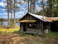
Most of the land surrounding this river was owned by lumber companies like International Paper. For the last hundred years or so, they leased parcels of land to families and hunting clubs who would build these camps and pass them down through a few generations. Over the last several years, the state of New York has been buying up large tracts of land like this via the Nature Conservancy to revert them to Wilderness, or Primitive Area status. In doing so the leases were ended and the camps left to either rot or eventually be removed.
Over the course of 20 miles, only a few camps were visible. Some long ago abandoned and not fit to be called shelter, and one just had the grass mowed from the bank to what I would be proud to call my only home. I would surely be upset to be forced to abandon such a financial and emotional investment that was handed down from my grandfather, but at the same time, it was always leased land…
With that in mind, it was time to load up and make a mile, and find a camp of our own to lease for the night. We had gotten a late start with the three hour drive from Vermont, and Patrick’s required stop at Chick-fil-A in Plattsburgh, so it was now late afternoon with three miles of relaxing flatwater between us and the next campsite on the map.
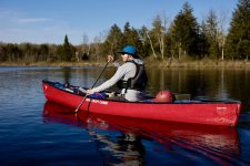
The year before, Patrick and I had pushed on through the next 10 miles of mostly flatwater and headwinds, in highly rockered whitewater boats with a few rapids mixed in, to get to a campsite just above Moosehead Rapids at sunset. That was based on a limited two-day schedule and not knowing what to expect.
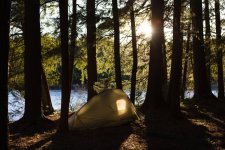
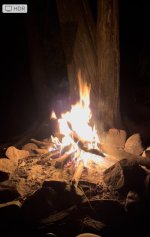
This year we decided on a more leisurely, three-day schedule to allow for sleeping in, hopes of fishing amidst these seemingly untouched waters and less of a grind in general. Within an hour from Sol’s Island we were setting up our tents on Burnt Island and scrounging for firewood, just in time for cocktail hour. Judging by the time stamp on the campfire photo, cocktail hour went til 11pm and explained why we never caught any fish that next morning.
To be continued…
We’ll, it’s late January and well into canoe-trip-planning season. I’m looking at a few routes that I’ve never done before, but also hoping to return, for the third year in a row, down the Lower Raquette River in the northern Adirondacks.
Not to be confused with the popular flatwater stretch upstream, between Long Lake and Tupper Lake, this stretch from Piercefield to Jamestown Falls is much quieter and much more entertaining with its numerous class II-III rapids and large, scenic waterfalls to break up the flatwater stretches. I think the rapids tend to keep the riff-raff out of this area because it’s in the local guidebook, yet seems to get very little traffic and it’s hard to find any trip reports or info on it. In fact, I feel a little guilty posting it here, but I trust this crowd to keep the secret close, or at least say hi if I bump into you there.
Last year, Patrick and I were able to talk our friend Brian into coming along for the ride after showing him some videos from the year before. Though it’s been awhile, in a kayak to boot, Brian has more whitewater experience than either of us, so he was a welcome addition to the crew. It’s always fun to have a competent paddler in the bow who’ll talk you into running that questionable line. He also proved to have excellent swimming skills that would come in handy.
Patrick… well, Patrick brought the comic relief and a cooler full of beer. Two essential skills to have on any self-respecting canoe trip.

He and I had run this stretch the previous spring of 2021 at slightly higher water levels in technical whitewater solos, mostly because we didn’t know what we were getting into with a map rating the mandatory Moosehead rapid as a potential III+. This year we brought more tripping oriented boats to make the flats and afternoon headwinds more tolerable. Patrick in his RX Nova Craft Supernova and Brian and I in my Old Town Appalachian, they were definitely a better overall fit for this stretch and still capable enough for the majority of the whitewater.
We put in at the town beach just below the dam for two reasons. One, the portage around the north side of the dam sucks. It’s rough, steep, long enough and a terrible way to start a trip. Two, coming in on Dead Creek skips a long, fun, class II warm up rapid. I recommend dropping your boat and gear at the beach, parking at the public lot at Piercefield Flow on the east side of the Rt 3 bridge and walk 10 minutes back to the beach.
Finally on the water, we pass the last few houses and leave civilization behind as we round the first bend and the river instantly takes on a wilderness feel. The opening warmup rapid is pretty straightforward, read-and-run with the easiest line down center-right. If you’ve got a really dry boat and are looking for some spice, you could run the giant, 3-4’ wave train on river left as seen in this photo from our 2021 trip.

After about a mile of flatwater rounding the western side of Sol’s Island, we approach the top of Upper Sol’s rapid and notice a couple crows take flight from the middle of the river. After a quick scout from the portage trail on river left, we took a slight detour across the river to investigate. What we found was an adult moose that had apparently drowned due to a hoof entrapment!

I’m no wildlife forensics expert, so it’s hard to say if it had fallen through the ice at some point over the winter, or if it was swept downstream during spring flows in an attempted crossing, but it was clearly not wearing a life jacket and that was most likely a contributing factor.

Upper Sol’s is really two rapids. The first part being a pretty easy class II right down the middle followed by short break in the action that gives you plenty of time to eddy-out river left and portage around the real Upper Sol’s, a tall, glassy surf wave followed by a 5-6’ drop into a sticky, riverwide souse hole.


The map says this rapid is a III+ and Lower Sol’s is a class IV-V, but it’s really the other way around. After much deliberation, and portaging our gear, we decided we’d run a line down the far river right of Lower Sol’s, a solid III, but relatively short.

We found a weakness at the far right end of a riverwide ledge that dropped three feet into a big standing wave, but then had to instantly cut a hard left and ferry to river center to avoid another ledge directly below. The shock of the initial drop left me a little slow to start my pries, but Brian performed like clockwork as if this was his third lap of the day. We got over just in time but still greased over one rock buried in the exit waves.


Patrick wasn’t as lucky. Maybe it was the difference between one paddle in the water and two. Maybe it was the aerated water that left his draw strokes ineffective, but he couldn’t get over fast enough to avoid the next ledge. However, he did an excellent job parallel parking his boat onto that ledge and calmly stepping out onto the rock in a manner that resembled a drift maneuver from the Fast and the Furious movies. Brian and I sitting in the eddy just below him thinking he was about to hand us the keys like we were a couple valets at the Waldorf Astoria.

After playing in the waves for a couple more minutes, we paddled over to the beautiful rock point at the base of the rapid to collect the rest of our gear and have a beer while soaking up the sun and overlooking the now widened river and Mt. Matumbla that dominates the skyline behind. There’s no doubt why someone chose this spot long ago to build their camp.

Most of the land surrounding this river was owned by lumber companies like International Paper. For the last hundred years or so, they leased parcels of land to families and hunting clubs who would build these camps and pass them down through a few generations. Over the last several years, the state of New York has been buying up large tracts of land like this via the Nature Conservancy to revert them to Wilderness, or Primitive Area status. In doing so the leases were ended and the camps left to either rot or eventually be removed.
Over the course of 20 miles, only a few camps were visible. Some long ago abandoned and not fit to be called shelter, and one just had the grass mowed from the bank to what I would be proud to call my only home. I would surely be upset to be forced to abandon such a financial and emotional investment that was handed down from my grandfather, but at the same time, it was always leased land…
With that in mind, it was time to load up and make a mile, and find a camp of our own to lease for the night. We had gotten a late start with the three hour drive from Vermont, and Patrick’s required stop at Chick-fil-A in Plattsburgh, so it was now late afternoon with three miles of relaxing flatwater between us and the next campsite on the map.

The year before, Patrick and I had pushed on through the next 10 miles of mostly flatwater and headwinds, in highly rockered whitewater boats with a few rapids mixed in, to get to a campsite just above Moosehead Rapids at sunset. That was based on a limited two-day schedule and not knowing what to expect.
This year we decided on a more leisurely, three-day schedule to allow for sleeping in, hopes of fishing amidst these seemingly untouched waters and less of a grind in general. Within an hour from Sol’s Island we were setting up our tents on Burnt Island and scrounging for firewood, just in time for cocktail hour. Judging by the time stamp on the campfire photo, cocktail hour went til 11pm and explained why we never caught any fish that next morning.


To be continued…
