Here's another report I posted on Myccr last year. This route is part of a vast network of routes on the east side of Lake Nipigon. We are continuing with the work this summer, opening up a key port to make access to lake Nipigon from Geraldton.
Ran this trip late August 2012. The first part of the Kap is a nice run that we maintain as part of the Marshall lake loop. The second part consists of the Kap from Stewart Lake, down to Tennant Lake, Kapikotongwa Lake, Melchett lake, Nass lake and Durer lake. It is an awesome trip, full of white water, large lakes and excellent fishing. Our trip was only about 95 k, but can easily be extended with a variety of options. Fishing for walleye is excellent.

We were a party of four, my buddy Rob and I going solo, and Rob’s dad and his pal going tandem. I had received special permission from MNR to access a restricted road to Durer Lake to end our trip. We dropped my truck off at Durer, and then drove to the Kap bridge on the Ogoki road.

The first part of the trip runs through Sedgeman park, a low wetland area. The Kap is broad and slow moving at this point. It takes about six or more hours of paddling to get to the fast stuff. We stopped at a small un-named lake that we call the Esker Hilton, due to the luxurious beach.

However, like many Crown Lake spots that can be accessed by boat, the Hilton is becoming dirty. In fact, what you see below was one of the sights that greeted us. Very bizarre.
 The throne at the Hilton.

I had just finished re-varnishing the Raven after it got banged up on the Steel. It was going to be a lot worse by the end of this trip.

I was anxious to try out my new Vital wood burner. Got it from Home Hardware fro 79 bucks. It was awesome. It is extremely sturdy and very sure footed. The instructions say you can put 50 pounds on top of it, and I believe it. I precut a pile of wood I split into about 3 inch pieces. If you make it under ½ inch thick, you can slide it under the pot while cooking. With the fan on high, it boils water very quickly, and the low setting provides a nice simmer. For the price, it’s a great little stove

From the Esker Hilton, we paddled down through Berger Lake and then down the Kap for a few hours until we started hitting the rapids. The water was very low. Under normal conditions, there is about a 15 kilometer stretch with one rapid after another.

They were all pretty small right now though. We shot or lined several sets until we got to the big port.

My buddy Rob and his dad and their friend Dave had come down this far in late September last year. When they got to the 1 k port, Rob used almost all his gas for the chainsaw and then they hit a snow storm, so they retreated back to the bridge. There was a huge blowdown that covered a large region of N. Ontario around 2001. Keep this in mind if you are canoeing in the area. Any port that existed before the blowdown does not exist now unless it has been re-cut.
Here’s what the port looked like after they cut it last September.

I decided I wanted to have a look at the large section of rapids that the port went around, so I decided to line down. The rest of the party advised me not too, and I should have listened to their advice. It was the longest continuous lining I have ever done, and it was quite difficult to boot. Took me an hour and a half. The were just finishing porting when I got to the bottom, bruised and soaked. I seem to recall someone from the old days of Myccr saying that they ran this particular set and lost a canoe. I wouldn’t recommend anyone running this set under high or medium water conditions. It looks like it could easily be a C4 or more.
 One small section of the large set of rapids.
From there we shot a few more sets before camping on a jackpine ridge for the night.
 Shooting the last few sets before camp.
 Jackpine camp on ridge on the Kap.

Much of this stretch of river was burned in a fire in 1997. It is coming back nicely now.

Due to the low water, we did a lot of lining. Many of the rapids were just to boney to run.

The walleye fishing is superb on this trip. From the first rapid to Tennant Lake, every pool is full of fat healthy fish. I know no one has been back here for ten years, because the ports were completely disappeared before we cut them. The port after this pool was obliterated by the blowdown. It took us two hours of scouting to re-establish the line, then another hour or two of cutting and clearing to open up the 500 meters.

After the rapid stretch of the river, we paddled Tennant Lake, Kapikotongwa lake and Melchett lake. These are all gorgeous isolated lakes. They each have an outpost camp on them, but we only saw one boat on Kap lake. The shot above is typical Northern Ontario, a lone tree on a small rock island in Melchett Lake.

This was our supper rig on Melchett.

View from the beach on Melchett.

The beach on Melchett.
We paddled out of Melchett and re-estsablished another “disappeared” port. It was only 370 meters, but we cut and cleared for two or three hours. From there, we paddled Briarcliff, Nass and Durer to get out to the truck.

It was a precarious looking load, but I just had to drive the bush roads back to my buddy’s truck so we could divide the load. Overall, it was a great trip, feels good to have it open again. It would be a good starting point for someone wanting to do the Little Current. You would just continue on from Nass over a series of small lakes to Percy Lake and then down the L. Current.
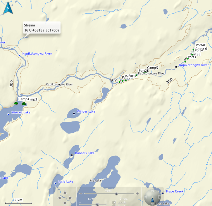
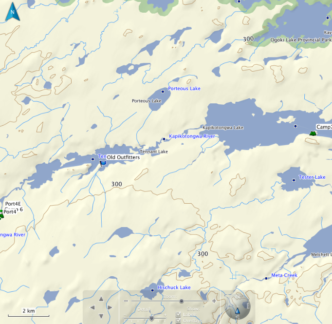
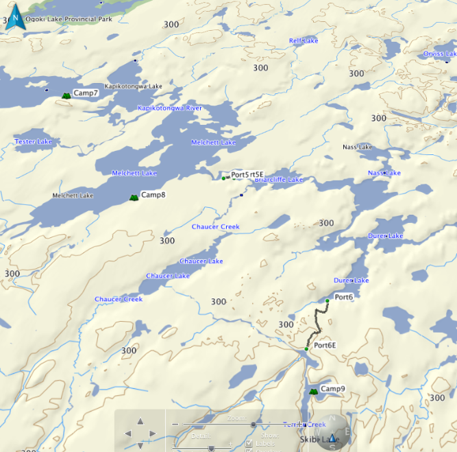
Here's some rough maps of the area.
Ran this trip late August 2012. The first part of the Kap is a nice run that we maintain as part of the Marshall lake loop. The second part consists of the Kap from Stewart Lake, down to Tennant Lake, Kapikotongwa Lake, Melchett lake, Nass lake and Durer lake. It is an awesome trip, full of white water, large lakes and excellent fishing. Our trip was only about 95 k, but can easily be extended with a variety of options. Fishing for walleye is excellent.
We were a party of four, my buddy Rob and I going solo, and Rob’s dad and his pal going tandem. I had received special permission from MNR to access a restricted road to Durer Lake to end our trip. We dropped my truck off at Durer, and then drove to the Kap bridge on the Ogoki road.
The first part of the trip runs through Sedgeman park, a low wetland area. The Kap is broad and slow moving at this point. It takes about six or more hours of paddling to get to the fast stuff. We stopped at a small un-named lake that we call the Esker Hilton, due to the luxurious beach.
However, like many Crown Lake spots that can be accessed by boat, the Hilton is becoming dirty. In fact, what you see below was one of the sights that greeted us. Very bizarre.
I had just finished re-varnishing the Raven after it got banged up on the Steel. It was going to be a lot worse by the end of this trip.
I was anxious to try out my new Vital wood burner. Got it from Home Hardware fro 79 bucks. It was awesome. It is extremely sturdy and very sure footed. The instructions say you can put 50 pounds on top of it, and I believe it. I precut a pile of wood I split into about 3 inch pieces. If you make it under ½ inch thick, you can slide it under the pot while cooking. With the fan on high, it boils water very quickly, and the low setting provides a nice simmer. For the price, it’s a great little stove
From the Esker Hilton, we paddled down through Berger Lake and then down the Kap for a few hours until we started hitting the rapids. The water was very low. Under normal conditions, there is about a 15 kilometer stretch with one rapid after another.
They were all pretty small right now though. We shot or lined several sets until we got to the big port.
My buddy Rob and his dad and their friend Dave had come down this far in late September last year. When they got to the 1 k port, Rob used almost all his gas for the chainsaw and then they hit a snow storm, so they retreated back to the bridge. There was a huge blowdown that covered a large region of N. Ontario around 2001. Keep this in mind if you are canoeing in the area. Any port that existed before the blowdown does not exist now unless it has been re-cut.
Here’s what the port looked like after they cut it last September.
I decided I wanted to have a look at the large section of rapids that the port went around, so I decided to line down. The rest of the party advised me not too, and I should have listened to their advice. It was the longest continuous lining I have ever done, and it was quite difficult to boot. Took me an hour and a half. The were just finishing porting when I got to the bottom, bruised and soaked. I seem to recall someone from the old days of Myccr saying that they ran this particular set and lost a canoe. I wouldn’t recommend anyone running this set under high or medium water conditions. It looks like it could easily be a C4 or more.
From there we shot a few more sets before camping on a jackpine ridge for the night.
Much of this stretch of river was burned in a fire in 1997. It is coming back nicely now.
Due to the low water, we did a lot of lining. Many of the rapids were just to boney to run.
The walleye fishing is superb on this trip. From the first rapid to Tennant Lake, every pool is full of fat healthy fish. I know no one has been back here for ten years, because the ports were completely disappeared before we cut them. The port after this pool was obliterated by the blowdown. It took us two hours of scouting to re-establish the line, then another hour or two of cutting and clearing to open up the 500 meters.
After the rapid stretch of the river, we paddled Tennant Lake, Kapikotongwa lake and Melchett lake. These are all gorgeous isolated lakes. They each have an outpost camp on them, but we only saw one boat on Kap lake. The shot above is typical Northern Ontario, a lone tree on a small rock island in Melchett Lake.
This was our supper rig on Melchett.
View from the beach on Melchett.
The beach on Melchett.
We paddled out of Melchett and re-estsablished another “disappeared” port. It was only 370 meters, but we cut and cleared for two or three hours. From there, we paddled Briarcliff, Nass and Durer to get out to the truck.
It was a precarious looking load, but I just had to drive the bush roads back to my buddy’s truck so we could divide the load. Overall, it was a great trip, feels good to have it open again. It would be a good starting point for someone wanting to do the Little Current. You would just continue on from Nass over a series of small lakes to Percy Lake and then down the L. Current.
Here's some rough maps of the area.
Last edited: