Food is love, brother.
-
Happy Patent for First Computer Mouse (1970)! 🖥️🖱️🐁
You are using an out of date browser. It may not display this or other websites correctly.
You should upgrade or use an alternative browser.
You should upgrade or use an alternative browser.
Reservoir Manicouagan QC Aug/Sep 2025
- Thread starter recped
- Start date
August 25 - Day 6
Distance: 21.8km (Total 88.2km)
Time: 6hr 7m
Caltopo Map: https://caltopo.com/m/B8MTMST
I was up at 8:00am; the sun was heating up the POD, I know this will not last; rain is likely to return in a few hours. I will try to get on the before that happens and will have my dry top at the ready (I am almost wearing semi-dry pants). I thought about having some eggs for breakfast but decided to keep it simple and go with the oatmeal and dried fruit option. Packing and lugging everything down to the water took time but I managed to depart at 11:40am (any departure before noon is a minor miracle!).


More cloud moved in as I left, very low, up ahead I could see the rain; it passed before I reached it. Oddly, I have tailwind coming from the east while the clouds are moving directly to the north. This seems to be a pattern; the wind at water level is not in harmony with what is in the sky even when the ceiling is only perhaps 500 - 1000ft. A second band of rain passed behind me, the edge was hitting me with a medium downpour. These clouds are so low that the opposite shore and the high hills are completely obscured. For the next few hours, the rain is steady with periods of heavy precipitation. There is a lot of water accumulating and sloshing around at my feet, I could have used my sponge but instead I fantasized about having an electric bilge pump and let it accumulate! With the features ahead obscured, it was difficult to access my exact location, just the GPS to tell me how far I had come. Around 4:30pm a couple of small patches of blue sky appeared, the rain started to taper (both were temporary). I finally reached the area that offers a bunch of coves and points. Unfortunately, the “beaches” were covered with large boulders. I investigated one of the deeper coves, not great for wind protection given there is a gap in the hills that is channelling wind directly on this location. I moved on to the next possibility, I found an area of sand right back at the tree line, there is a good flat spot with no wind at this time. Not right beside the water but still a much shorter “hike” that the previous camp. I am not enamoured of sand, especially wet sand but it ticks the boxes so I set up here.


Once set up and after the required relaxation period I boiled some water for my first Meal In A Bag (MIAB), Alpine Aire Spicy Sausage Pasta. It is spicy but otherwise quite dull, one to avoid in the future. While I am waiting for rehydration, I hear thunder from the west, it gets closer and then hits with heavy rain that is so hard the condensation that collects on the inside of the POD is sprinkling down on me. This issue occurs under certain conditions; wet ground, all screens covered and the right combination of humidity and temperature. After 45 minutes, it is over, a few minutes later I thought I heard more thunder but it turned out to be a jet passing over. I am under a regular flightpath for jets heading to and from parts of Europe and South Asia to Toronto; mostly they are quite high and not too noisy if I hear them at all. At 11:30pm, I had some pie, still slowly making my way through it! It is very still out, I cannot see it but I am sure the water is very calm, it would be wonderful if it stayed that way through tomorrow but it is unlikely. I would settle for some sun, even some of the time. I should be moving on; I will get a weather update in the morning and make a final decision then.

Distance: 21.8km (Total 88.2km)
Time: 6hr 7m
Caltopo Map: https://caltopo.com/m/B8MTMST
I was up at 8:00am; the sun was heating up the POD, I know this will not last; rain is likely to return in a few hours. I will try to get on the before that happens and will have my dry top at the ready (I am almost wearing semi-dry pants). I thought about having some eggs for breakfast but decided to keep it simple and go with the oatmeal and dried fruit option. Packing and lugging everything down to the water took time but I managed to depart at 11:40am (any departure before noon is a minor miracle!).
More cloud moved in as I left, very low, up ahead I could see the rain; it passed before I reached it. Oddly, I have tailwind coming from the east while the clouds are moving directly to the north. This seems to be a pattern; the wind at water level is not in harmony with what is in the sky even when the ceiling is only perhaps 500 - 1000ft. A second band of rain passed behind me, the edge was hitting me with a medium downpour. These clouds are so low that the opposite shore and the high hills are completely obscured. For the next few hours, the rain is steady with periods of heavy precipitation. There is a lot of water accumulating and sloshing around at my feet, I could have used my sponge but instead I fantasized about having an electric bilge pump and let it accumulate! With the features ahead obscured, it was difficult to access my exact location, just the GPS to tell me how far I had come. Around 4:30pm a couple of small patches of blue sky appeared, the rain started to taper (both were temporary). I finally reached the area that offers a bunch of coves and points. Unfortunately, the “beaches” were covered with large boulders. I investigated one of the deeper coves, not great for wind protection given there is a gap in the hills that is channelling wind directly on this location. I moved on to the next possibility, I found an area of sand right back at the tree line, there is a good flat spot with no wind at this time. Not right beside the water but still a much shorter “hike” that the previous camp. I am not enamoured of sand, especially wet sand but it ticks the boxes so I set up here.
Once set up and after the required relaxation period I boiled some water for my first Meal In A Bag (MIAB), Alpine Aire Spicy Sausage Pasta. It is spicy but otherwise quite dull, one to avoid in the future. While I am waiting for rehydration, I hear thunder from the west, it gets closer and then hits with heavy rain that is so hard the condensation that collects on the inside of the POD is sprinkling down on me. This issue occurs under certain conditions; wet ground, all screens covered and the right combination of humidity and temperature. After 45 minutes, it is over, a few minutes later I thought I heard more thunder but it turned out to be a jet passing over. I am under a regular flightpath for jets heading to and from parts of Europe and South Asia to Toronto; mostly they are quite high and not too noisy if I hear them at all. At 11:30pm, I had some pie, still slowly making my way through it! It is very still out, I cannot see it but I am sure the water is very calm, it would be wonderful if it stayed that way through tomorrow but it is unlikely. I would settle for some sun, even some of the time. I should be moving on; I will get a weather update in the morning and make a final decision then.
Thanks for keeping this report going. I'm enjoying it! Interesting scenery.
The more I think about this sentence the more confused I get at the multitude of meanings:
The more I think about this sentence the more confused I get at the multitude of meanings:
I am almost wearing semi-dry pants
- Joined
- Aug 10, 2018
- Messages
- 1,989
- Reaction score
- 3,219
I've never been a fan of camping on sand either but that's a pretty good-looking site.
I'm really enjoying the report also. Should we be thankful that there are no pictures of the "almost worn" pants?
I'm really enjoying the report also. Should we be thankful that there are no pictures of the "almost worn" pants?
In that context I was outlining my preparations for what would likely be a very wet day of paddling. If you look at my selfie pic at the put-in I am wearing my standard outfit, Gore-Tex dry pants (aka waders) and a splash jacket, because the pants (integrated booties) do not have a waist gasket they are "semi-dry" (if you swim they fill up with water).
On most of my river trips I am in an out of the boat frequently, also running lots of rapids and because it usually involves cold water I generally wear a full dry suit. For this kind of all flatwater trip a full dry suite would be overkill. The water temps on the reservoir in August are not very cold and the risk of a swim is close to zero so I just use the dry pants. For my upper body It's usually just a t-shirt plus splash jacket with a semi-dry top in reserve for rainy days. On a nice sunny/warm day I will strip down somewhat but I rarely go with shorts and a t-shirt because for most of my trips it's just not that warm.
Another reason for covering up is the bugs, in the more northerly areas of Ontario/Quebec the bugs (black flies primarily) arrive in mid to late May and never go away until late September so I prefer to have a little exposed flesh as possible. On this trip the bugs were in relative terms pretty easy to deal with. On the water there were very few but if I make a stop to get out for a stretch they arrive immediately. Of course I carry some deet, it's effective but I try to avoid applying the stuff (never used it at all on this trip) and just ensure I have as little exposed skin as possible and use a head net when necessary.
@Gamma1214 @Alan Gage
I just noticed the error when I posted the pants comment.....
"I am almost wearing semi-dry pants" is missing a word, should have been "I am almost Always wearing semi-dry pants"
Sorry about the confusion....I think I was too high last night!
Last edited:
- Joined
- Aug 10, 2018
- Messages
- 1,989
- Reaction score
- 3,219
No worries, I'd kinda assumed that there was supposed to be an "always" in there but it was just TOO easy & I couldn't resist. (alright, I guess I could but what fun is that?)
Looking forward to the next chapter
Looking forward to the next chapter
I'm still kinda stuck on the chicken, probably would prefer an "almost pants" pic to that stewing mass of biological contaminant. Just Kidd'n, keep the pictures coming.
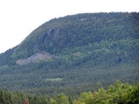
I like this picture a lot. Is that the mainland across the open water?

Yes, it is the mainland to the north, you can see on the map it's one of the areas where the gap distance is relatively small.
For scale, the shelter is about 6' 6" at the peak, I'm short so I can stand up in almost all of it except the corners.
For scale, the shelter is about 6' 6" at the peak, I'm short so I can stand up in almost all of it except the corners.
August 26 - Day 7
Distance: 0km (Total 88.2km)
Time: 0hr 0m
Caltopo Map: https://caltopo.com/m/B8MTMST
I woke up for the first time at 5:00am then back to sleep for a few hours. At 10:30am the sun was hitting the POD, condensation that had accumulated in the night was dripping, I opened up the screen windows to allow the interior to dry out. I am not feeling particularly energetic, unsure about paddling today. The forecast indicates some wind and rain. Eventually I boiled water for tea to go with bread and cheese, a clementine and several cigarettes. About 1:00pm, I ordered up another forecast for the next two days, gradual improvement is coming, high pressure moving in, humidity falling. While I have been waffling about packing up or having a second layover day time has been marching on. At 2:00pm, there is a sprinkle of rain, the wind has been picking up and it is likely to be in my face. At this point it is so late that packing up and paddling seems pointless given I would probably only have 4 hours of paddling time before needing to camp. I have convinced myself that I should opt for plan B, stay where I am, get to bed early, get up early, and make up for it tomorrow. I make it official with a notification to Mapshare.


Not a lot to do so a good time for a nap, at 6:30pm I woke up to a little light rain, lots of cloud and greatly increased wind (still not REALLY bad). I spent a couple of hours snacking, studying maps, looking at the forecast yet again and updating my notebook. I also had intermittent chats with a frog that had dropped by for a visit. Eventually I made a MIAB, Alpine Aire Grilled Chicken Pad Thai, the seasoning of this one is a bit of a shock but after a couple of spoonful’s I’m really liking it. Plenty of chewy chicken, feeling somewhat stuffed I decide to postpone tonight’s dessert (pie of course) for an hour.

Distance: 0km (Total 88.2km)
Time: 0hr 0m
Caltopo Map: https://caltopo.com/m/B8MTMST
I woke up for the first time at 5:00am then back to sleep for a few hours. At 10:30am the sun was hitting the POD, condensation that had accumulated in the night was dripping, I opened up the screen windows to allow the interior to dry out. I am not feeling particularly energetic, unsure about paddling today. The forecast indicates some wind and rain. Eventually I boiled water for tea to go with bread and cheese, a clementine and several cigarettes. About 1:00pm, I ordered up another forecast for the next two days, gradual improvement is coming, high pressure moving in, humidity falling. While I have been waffling about packing up or having a second layover day time has been marching on. At 2:00pm, there is a sprinkle of rain, the wind has been picking up and it is likely to be in my face. At this point it is so late that packing up and paddling seems pointless given I would probably only have 4 hours of paddling time before needing to camp. I have convinced myself that I should opt for plan B, stay where I am, get to bed early, get up early, and make up for it tomorrow. I make it official with a notification to Mapshare.
Not a lot to do so a good time for a nap, at 6:30pm I woke up to a little light rain, lots of cloud and greatly increased wind (still not REALLY bad). I spent a couple of hours snacking, studying maps, looking at the forecast yet again and updating my notebook. I also had intermittent chats with a frog that had dropped by for a visit. Eventually I made a MIAB, Alpine Aire Grilled Chicken Pad Thai, the seasoning of this one is a bit of a shock but after a couple of spoonful’s I’m really liking it. Plenty of chewy chicken, feeling somewhat stuffed I decide to postpone tonight’s dessert (pie of course) for an hour.
I notice that the water looks low. If it were high would you still have a lot of campsite options?
I notice that the water looks low. If it were high would you still have a lot of campsite options?
It would definitely not be as easy. Although levels do vary somewhat due to normal seasonal changes most of the variations are a result of Quebec Hydro's power generating needs. When there is more demand for power from the northeast US (where a huge amount of Quebec's electricity ends up) they increase the flow going through the 5 power stations on the lower river (Manic-1 through Manic-5). Quebec Hydro has a somewhat controversial plan to maintain much higher average levels in the coming years in order to deal with greater variations in demand from their customers (primarily in the northeast US). The other factor is climate change which has led to much greater variation in annual precipitation. It's possible that I picked the very best year to paddle the reservoir if your considerations are for easy camping. In some of my pictures you can see that there is narrow band of deciduous growth between the old growth coniferous (mostly spruce and fir) forest and the "beaches". If Hydro-Quebec has it's way most of the "beaches" will be underwater year round. That narrow band of relatively recent growth would be the only available camping areas as the old growth boreal is mostly so dense it's near useless for camping.
Here is a Sat image from this year (Mid-July). The red dot is camp 6/7

Here is a Sat image from July 2017 when levels were considerably higher

August 27 - Day 8
Distance: 29.3km (Total 118.5km)
Time: 8hr 37m
Caltopo Map: https://caltopo.com/m/B8MTMST
I was up and active at 6:45am, there was a few patches of blue sky, even the sun briefly appeared a couple of times but it did not last long. Light grey cloud soon covered 100% of the sky. I slowly got organized, boiled water for tea and oatmeal. By 9:00am I was packing, as I did that the wind started to pick up with light rain added to the mix. Much of my gear is a bit damp, nothing serious, the kind of thing that one could dry out with just an hour or two of sunshine. This issue comes as no surprise, the relative humidity has been at 90%+ for the past few days while temperatures have been in the low double digits (Celsius).


I set off at 11:05am, one hour later than what I had hoped for. The rain has gone away, mostly cloudy, from time to time the sun shines for a few minutes. The wind is not too bad but the waves are a constant and not helpful, fortunately, they are not too big but I am seeing some micro-whitecaps. I am still making good progress although it is hurting my average speed somewhat. I made one short stop to stretch my legs, after my stop the wind further diminished and along with that, the waves calmed down.


When I reached the halfway point to my target, I decided to start my crossover to the outer shore. This was a slow and frustrating experience; an island that was my initial target, I would look up and see it getting closer, concentrate on paddling them look up again and it would appear to be farther away than when I started. Occasionally I would peek behind me and be shocked how close the shore still seemed to be. At this point I was developing a minor case of “cabin fever” (I will describe that later) combined with an understanding that “severe cabin disappointment” is always a possibility. At last I made the turn into the bay where the cabin is supposedly located, I saw hint of a cabin. I had a waypoint for the location on my GPS so I set a Go To, 2km further so I went deep into the bay. I found the outflow of a river in the far corner. Proceeding through a narrow “canyon”, I could hear the sound of a rapid and imagined a nice little cabin overlooking the rushing river. When I reached the bottom of the rapid there was no cabin, my GPS is showing that I had gone right past it so I turned back. Watching the GPS countdown to 60 meters then pause before climbing again, there is no cabin and I am disappointed.


It is getting late; the sun has set so I hunt for the closest place to camp. Fortunately, I found a reasonable spot not far away; I set up as quickly as possible. Once installed in my shelter it is time for more clothing and after such a long day I am hungry for dinner, I randomly picked out a MIAB, Mountain House Lasagne with Meat Sauce. It is one of their “Pro Pack” “single serving” meals (classic shrinkflation). It disappears fast, not because it is that great but rather that maybe for the first time on this trip I am feeling a caloric deficiency. I added some pie, a cookie and some chocolate, which helped satisfy my needs.
It is now after midnight, I have a basic plan for tomorrow, get up sometime. Paddle about 14km and camp across from some cliffs on the big island. If I have the time, I might cross back over to the camp under the cliffs, as the crossing is only 3km at that point.
Distance: 29.3km (Total 118.5km)
Time: 8hr 37m
Caltopo Map: https://caltopo.com/m/B8MTMST
I was up and active at 6:45am, there was a few patches of blue sky, even the sun briefly appeared a couple of times but it did not last long. Light grey cloud soon covered 100% of the sky. I slowly got organized, boiled water for tea and oatmeal. By 9:00am I was packing, as I did that the wind started to pick up with light rain added to the mix. Much of my gear is a bit damp, nothing serious, the kind of thing that one could dry out with just an hour or two of sunshine. This issue comes as no surprise, the relative humidity has been at 90%+ for the past few days while temperatures have been in the low double digits (Celsius).
I set off at 11:05am, one hour later than what I had hoped for. The rain has gone away, mostly cloudy, from time to time the sun shines for a few minutes. The wind is not too bad but the waves are a constant and not helpful, fortunately, they are not too big but I am seeing some micro-whitecaps. I am still making good progress although it is hurting my average speed somewhat. I made one short stop to stretch my legs, after my stop the wind further diminished and along with that, the waves calmed down.
When I reached the halfway point to my target, I decided to start my crossover to the outer shore. This was a slow and frustrating experience; an island that was my initial target, I would look up and see it getting closer, concentrate on paddling them look up again and it would appear to be farther away than when I started. Occasionally I would peek behind me and be shocked how close the shore still seemed to be. At this point I was developing a minor case of “cabin fever” (I will describe that later) combined with an understanding that “severe cabin disappointment” is always a possibility. At last I made the turn into the bay where the cabin is supposedly located, I saw hint of a cabin. I had a waypoint for the location on my GPS so I set a Go To, 2km further so I went deep into the bay. I found the outflow of a river in the far corner. Proceeding through a narrow “canyon”, I could hear the sound of a rapid and imagined a nice little cabin overlooking the rushing river. When I reached the bottom of the rapid there was no cabin, my GPS is showing that I had gone right past it so I turned back. Watching the GPS countdown to 60 meters then pause before climbing again, there is no cabin and I am disappointed.
It is getting late; the sun has set so I hunt for the closest place to camp. Fortunately, I found a reasonable spot not far away; I set up as quickly as possible. Once installed in my shelter it is time for more clothing and after such a long day I am hungry for dinner, I randomly picked out a MIAB, Mountain House Lasagne with Meat Sauce. It is one of their “Pro Pack” “single serving” meals (classic shrinkflation). It disappears fast, not because it is that great but rather that maybe for the first time on this trip I am feeling a caloric deficiency. I added some pie, a cookie and some chocolate, which helped satisfy my needs.
It is now after midnight, I have a basic plan for tomorrow, get up sometime. Paddle about 14km and camp across from some cliffs on the big island. If I have the time, I might cross back over to the camp under the cliffs, as the crossing is only 3km at that point.
Attachments
August 28 - Day 9
Distance: 15.2km (Total 133.7km)
Time: 4hr 38m
Caltopo Map: https://caltopo.com/m/B8MTMST
I woke just after 6:00am, rolled over for another 3 hours of bliss. By this time the sun was hitting the POD, I opened up the screen covers to let the condensation escape. While I was opening the screens I looked over and saw the “missing” cabin, with the low water levels it was quite a hike up from the water, it also looked like it was very small and probably all bordered up.


It was another hour before I prepared my mug of tea and Thermos for later. For a quick and easy breakfast, I finished off my hummus supply with a couple of wraps. While I definitely planned to move on, I was in no hurry.

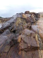
By 11:00am the clouds were covering the sky, it is going to be well after 1:00pm before I get out of here, good thing I am only planning to paddle for 4 hours or less. I was just about to load the canoe when I heard the sound of an incoming chopper, It zoomed directly over me at maybe 300ft, moving fast and headed to the northeast. As I finished loading, at the ridiculous time of 2:15pm, a few sprinkles of rain began which continued for almost an hour. I stopped at a couple of islands to take some pictures of rocks, they always look best when wet.


There was a very light wind from the south, only enough to create some ripples and the odd wave. This had a minimal effect of my progress as I paddled towards the area I would start to look for a camp. Although it was no longer raining the clouds were thick and low once again. When I reached the area, the shorelines were not that attractive, much of it covered with small boulders. Since it was only 5:30pm, I decided to cross over to the big island and look for a spot under the cliffs. The crossing took about an hour, first I checked out a sandy beach but the slope was too steep for my liking. A little further along I came to a narrow spit of mostly gravel, I will take gravel over sand any day so I set up here. Nice spot, view of the sunset should the clouds break up, sheltered by the hills, no bugs, nice dry ground right beside the water. I set up camp just as the sun was setting, for the first time since the early morning the sun was visible.


I decided to just munch on snack food tonight, plenty of fresh tea to go with cheese and crackers, cup-a-soup, Pringles, jerky, chocolate and the last bit of pie. Today I had reached the halfway point of the circumnavigation, I was ahead of my theoretical schedule so my plan for tomorrow is to get on the water earlier, just meander along the shore until I feel like stopping, maybe camp early enough to enjoy a few hours of daylight. Here in the most easterly part of the Eastern Time Zone the sun sets early, 7:30pm today and 2 minutes earlier each day.


Distance: 15.2km (Total 133.7km)
Time: 4hr 38m
Caltopo Map: https://caltopo.com/m/B8MTMST
I woke just after 6:00am, rolled over for another 3 hours of bliss. By this time the sun was hitting the POD, I opened up the screen covers to let the condensation escape. While I was opening the screens I looked over and saw the “missing” cabin, with the low water levels it was quite a hike up from the water, it also looked like it was very small and probably all bordered up.
It was another hour before I prepared my mug of tea and Thermos for later. For a quick and easy breakfast, I finished off my hummus supply with a couple of wraps. While I definitely planned to move on, I was in no hurry.
By 11:00am the clouds were covering the sky, it is going to be well after 1:00pm before I get out of here, good thing I am only planning to paddle for 4 hours or less. I was just about to load the canoe when I heard the sound of an incoming chopper, It zoomed directly over me at maybe 300ft, moving fast and headed to the northeast. As I finished loading, at the ridiculous time of 2:15pm, a few sprinkles of rain began which continued for almost an hour. I stopped at a couple of islands to take some pictures of rocks, they always look best when wet.
There was a very light wind from the south, only enough to create some ripples and the odd wave. This had a minimal effect of my progress as I paddled towards the area I would start to look for a camp. Although it was no longer raining the clouds were thick and low once again. When I reached the area, the shorelines were not that attractive, much of it covered with small boulders. Since it was only 5:30pm, I decided to cross over to the big island and look for a spot under the cliffs. The crossing took about an hour, first I checked out a sandy beach but the slope was too steep for my liking. A little further along I came to a narrow spit of mostly gravel, I will take gravel over sand any day so I set up here. Nice spot, view of the sunset should the clouds break up, sheltered by the hills, no bugs, nice dry ground right beside the water. I set up camp just as the sun was setting, for the first time since the early morning the sun was visible.
I decided to just munch on snack food tonight, plenty of fresh tea to go with cheese and crackers, cup-a-soup, Pringles, jerky, chocolate and the last bit of pie. Today I had reached the halfway point of the circumnavigation, I was ahead of my theoretical schedule so my plan for tomorrow is to get on the water earlier, just meander along the shore until I feel like stopping, maybe camp early enough to enjoy a few hours of daylight. Here in the most easterly part of the Eastern Time Zone the sun sets early, 7:30pm today and 2 minutes earlier each day.
Attachments

August 29 - Day 10
Distance: 14.7km (Total 148.4km)
Time: 4hr 15m
Caltopo Map: https://caltopo.com/m/B8MTMST


I stepped out at 7:30am, 100% cloud cover, back to bed for another 2 hours of sleep. It was still cloudy but there had not been any rain overnight. There is a bit of wind from the southwest that may be an issue, I am not too concerned because I do not plan on too far or too long today. For breakfast, I finished off my hummus supply and then made oatmeal with dried fruit. I made fresh tea for my mug and filled the Thermos for the “road” as the clouds started to dissipate.

A pair of loons stopped by, the loon population on the reservoir is substantial, I saw them most days and heard their call most nights.


Just before 2:30pm, I was finally packed and ready to go; the light wind had changed direction and was now a tailwind. I was heading for a cabin that was located at a long and narrow inlet in the area where I would start to turn to the east along the south end of the big island. I was not planning to stay there but I wanted to check it out. Along the way, there were quite a few cliffs to see, a few nice beaches as well.


When I reached the inlet, the low water became very noticeable, the shore is covered in grasses, the width is much narrower than I had thought from the topo map. I paddle north to where I expected to find the cabin and found the water just disappeared into a wide field of grass. The cabin came into sight; it was well back from the end of the water, it also looked very small. I hiked through the grass that hid old driftwood, there was then a swath of bushes where an actual path began (“normal” high water?), the first blueberries of the trip were scattered about. The cabin is about 12 x 12 and on stilts about 5ft high, the windows covered with plywood, the door covered in steel roofing metal with multiple screws. The steps and porch had nail beds to discourage bears. Under the cabin was an ample supply of cut firewood, a big propane tank and an very old beat up canoe (yeah I’m a dummy, I forgot to bring my camera). The canoe was a short (12ft), flat stern, 3 keels, no markings that I could see. The black flies were very annoying here so I did not hang out for long. On my way back to the canoe, I stopped to pick some blueberries. This gave the black flies a prime target that they took advantage; they chased me back to the canoe and then followed me out on the water.

Water level in 2017

Water level in 2025

I paddled back to the open water heading for the east point. Near the tip, there was a good flat area of course sand. With less than an hour until sunset, it was any easy choice to make.
I followed the usual set up routine, smoking, tea, cheese and crackers, cup-a-soup, more tea, Pringles and eventually a MIAB. Tonight the selection is Backpackers Pantry Shepard’s’ Potato Stew with Beef (single serving version). It did not smell or look very good, but when time came to eat it was not too bad.
While I was waiting for the re-hydration a salamander slithered by, I assisted it to find an exit. After I finished eating, I heard a rustling sound, found a frog trying to escape. I had to go out anyway so I picked it up and took it with me. The cloud cover is breaking up; I can see some stars for the first time in a week. When I returned to the POD, I encountered another larger salamander climbing over and under stuff on the “typar table”, I showed him the way out. I was just about to pull out my sleeping bag when I spotted my new “friend” scurrying across my Mondo pad. I figure it’s futile and suggested he find his own way out.


Renaming your POD Toad Hall.
I'm struggling here because I don't want this to come off as criticism. You have my utmost respect and I think it would be wise of me to not try and follow you anywhere. The Manic, solo, is not something I would attempt - I generally do not like big water.
Yet I feel compelled to remark at the absolute incompatibility of our tripping styles.
I joked about your 5-day chicken. I said I would have had 3 by that time, but who's kidding - I'd have easily eaten 7 or 8 of them by day 5. Getting up at 7am and then going back to bed is blowing my mind. I'm often up at 3:30 - 4:00. I'm looking for a place to camp for the night when you are just getting on the water.
Please keep the updates coming - I am loving the juxtaposition.
Being someone who doesn't sleep well, I envy people that can sleep like that. In his defense I also developed different sleep habits on a long solo trip in the long daylight hours of the North. I stayed up late and woke up early. I'd have a coffee and do some fishing. After a few hours I'd have breakfast and sometimes return to the tent, read a little and take a long nap before starting the rest of my day. I liked this routine because I got to enjoy my two favorite times of the day, dawn and dusk, which are only a few hours apart in the North. When I wasn't solo my sleep habits fell in line with the rest of the group.
As for that chicken, I believe some things are worth risking a case of diarrhea for. The Costco chicken isn't one of them, but I guess the rules change when you're on a trip.
As for that chicken, I believe some things are worth risking a case of diarrhea for. The Costco chicken isn't one of them, but I guess the rules change when you're on a trip.
LOL!As for that chicken, I believe some things are worth risking a case of diarrhea for. The Costco chicken isn't one of them,
Similar threads
- Replies
- 30
- Views
- 3K
- Replies
- 12
- Views
- 2K
- Replies
- 6
- Views
- 976