- Joined
- Mar 23, 2015
- Messages
- 114
- Reaction score
- 1
This fall I finally got to do a trip I've wanted to do for a very long time.... Roadends attempted getting into this area a while back and posted about it, but didn't have much luck. Information on the Wilderness can be found here: http://www.mccormicktract.com/ and https://www.fs.usda.gov/recarea/ottawa/recarea/?recid=12361
While in Alaska, another fishing guide and myself were looking for a trip to do once we got back to the lower 48. We didn't want to do something easy, and we wanted to do something we feel not many have done if any. I had this in my mind from when Roadends attempted it, and I talked him into going with me.
October 19th:
We got a late start at about 1:30 pm. One other car was in the parking lot. We unloaded our gear and began our first portage into the Wilderness.
Unlike roadends we figured we'd do the 2 mile portage into Lower Baraga Lake, and then camp on the lone campsite on that lake. Our plans changed when we came up on the first beaver pond about a half mile in from the parking area at the lower entry of the wilderness area and decided we'd try paddling upstream from there. After about 10 minutes we hit our first beaver dam. This would be the first of many. Shortly after that beaver dam we came up on the rock garden portion of the river that roadends turned around on. Knowing the trail we originally planned on taking was somewhere to our right, we decided to bushwack to it, and then take it the rest of the way. We did, which only ended up being about 300 yards of portaging. Taking the beaver pond paid off in time and effort!
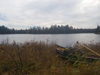
While paddling on Lower Baraga Lake we came up on the campsite we had hoped to camp on, and found it to be occupied, probably by the only other car we had seen. On the Forest Service map of the park (which i currently can't share because they suck at keeping useful maps available for download), they show a portage between Lower Baraga, and Upper Baraga Lakes. After some searching we found this portage. It hasn't' been used much lately if at all, it went through a very clear area, but with no clear indication where the trail was, other than that it felt like we were following an old stream path, it was good enough that I never had to pull out the map or compass and we made it to Upper Baraga rather quickly. We decided to see what we could find for a campsite on Upper Baraga Lake. Being a wilderness area, we full expected to find some kind of clearing to make due. However, lucky us, there was a campsite on the peninsula where the lake narrows down. A really nice campsite actually. You could tell it has been hiked into quite a bit.
October 20th:
After waking up we made a decent breakfast, packed up camp and began paddling up the lake. After getting to the top of the lake I pulled out the map and compass, got a bearing, and we began bushwacking to Clear Lake. We had enough things to double portage, and decided to carry packs first to figure out where we were going before leading the canoe through the thick pine stands. While bushwacking this portage we came up on a stream we expected to see, but thought we'd be able to find a way across. we were wrong, and actually ended up loading the canoe to get across this 14ft pond/stream/swamp. Then continued our way to Clear Lake.
Clear lake lives up to it's name. In an area with rust colored water, Clear lake is very clear, and absent of this colored water. It's also not a very big lake, at all. Just big enough that it wasn't work portaging around it, so we loaded the canoe to paddle across. On our way across we stopped in an area where a small wildfire had cleared some time ago and pulled up for a lunch of summer sausage and cheese.
Then we continued onto Island Lake. This is the lake I wanted to paddle. The reason I wanted to do this trip. Why did I want to paddle it? No idea. I'd never been there, but when I looked at the map of the McCormick Wilderness, it always stuck out to me.
EDIT: Going to finish this post tomorrow.
Pictures from this trip can be seen on my instagram: @bryansromalski ( https://www.instagram.com/bryansromalski/ ) You'll have to go back and find posts from Late October to see the pictures.
While in Alaska, another fishing guide and myself were looking for a trip to do once we got back to the lower 48. We didn't want to do something easy, and we wanted to do something we feel not many have done if any. I had this in my mind from when Roadends attempted it, and I talked him into going with me.
October 19th:
We got a late start at about 1:30 pm. One other car was in the parking lot. We unloaded our gear and began our first portage into the Wilderness.
Unlike roadends we figured we'd do the 2 mile portage into Lower Baraga Lake, and then camp on the lone campsite on that lake. Our plans changed when we came up on the first beaver pond about a half mile in from the parking area at the lower entry of the wilderness area and decided we'd try paddling upstream from there. After about 10 minutes we hit our first beaver dam. This would be the first of many. Shortly after that beaver dam we came up on the rock garden portion of the river that roadends turned around on. Knowing the trail we originally planned on taking was somewhere to our right, we decided to bushwack to it, and then take it the rest of the way. We did, which only ended up being about 300 yards of portaging. Taking the beaver pond paid off in time and effort!
While paddling on Lower Baraga Lake we came up on the campsite we had hoped to camp on, and found it to be occupied, probably by the only other car we had seen. On the Forest Service map of the park (which i currently can't share because they suck at keeping useful maps available for download), they show a portage between Lower Baraga, and Upper Baraga Lakes. After some searching we found this portage. It hasn't' been used much lately if at all, it went through a very clear area, but with no clear indication where the trail was, other than that it felt like we were following an old stream path, it was good enough that I never had to pull out the map or compass and we made it to Upper Baraga rather quickly. We decided to see what we could find for a campsite on Upper Baraga Lake. Being a wilderness area, we full expected to find some kind of clearing to make due. However, lucky us, there was a campsite on the peninsula where the lake narrows down. A really nice campsite actually. You could tell it has been hiked into quite a bit.
October 20th:
After waking up we made a decent breakfast, packed up camp and began paddling up the lake. After getting to the top of the lake I pulled out the map and compass, got a bearing, and we began bushwacking to Clear Lake. We had enough things to double portage, and decided to carry packs first to figure out where we were going before leading the canoe through the thick pine stands. While bushwacking this portage we came up on a stream we expected to see, but thought we'd be able to find a way across. we were wrong, and actually ended up loading the canoe to get across this 14ft pond/stream/swamp. Then continued our way to Clear Lake.
Clear lake lives up to it's name. In an area with rust colored water, Clear lake is very clear, and absent of this colored water. It's also not a very big lake, at all. Just big enough that it wasn't work portaging around it, so we loaded the canoe to paddle across. On our way across we stopped in an area where a small wildfire had cleared some time ago and pulled up for a lunch of summer sausage and cheese.
Then we continued onto Island Lake. This is the lake I wanted to paddle. The reason I wanted to do this trip. Why did I want to paddle it? No idea. I'd never been there, but when I looked at the map of the McCormick Wilderness, it always stuck out to me.
EDIT: Going to finish this post tomorrow.
Pictures from this trip can be seen on my instagram: @bryansromalski ( https://www.instagram.com/bryansromalski/ ) You'll have to go back and find posts from Late October to see the pictures.