• Happy Marine Mammal Rescue Day! 🐳🐬🦭🦦

Allagash - Starting from Churchill Dam

Joined
May 8, 2021
Messages
16
Reaction score
1
I am planning a trip to the Allagash this fall. I plan to start at Churchill Dam. I have done the Allagash several times before, starting at Johnson Pond, Indian Stream, and Lock Dam (when we used to fly in before they banned canoes from float planes.)

I understand that there is potable water available at the ranger station at Church Dam. I don't remember exactly where at the site the water source is and how far we would have to carry 5 gallon containers to where we will put in. Does anyone know? In the past, I have always just drank straight out of the lakes and river with no problems, but my son is a freak about clean water.
 
I've been there 4 times (as recently as May 14, 2023) and I had never heard they had water there. But I just looked on line and you are right. But it doesn't say exactly where. The structures are all across the dam from where you put in. Probably no more than 1000ft. between the put in and the furtherst structures, which are the ranger's cabins. That would be my bet. Maybe someone knows specifically.

I know people do drink out of the lakes/rivers, but I personally don't and bring a gravity filter. Just need a little beaver fever to make a trip very unpleasant.

(I've also started at Indian Stream, Johnson Pond, and Chamberlain Bridge. Never flew in.)
 
just bring a water filter. Have drunk out of it many times, but understand your son's concern. A water filter adds 8 oz to your kit. Yes there are springs but have not researched where. We have a lot of roadside springs in my area and as moose crap can get into them and they are not tested, I fail to see the allure of unfiltered spring water. BTW people who live in the area take water out of the river and lakes and just run them through a Britta or equivalent home filter.

The water will still be brown after filtering. It is full of natural tannins. Spring water has the same tint. I hope that does not freak your son out.
 
I didn't know there was water there either, I also always filter.

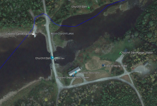
If you're a map nerd, the AWW distributes a KML file (for Google Earth and other programs) with the locations of campsites, relics and other odds and sods, including public drinking water as it turns out. Looks like it's between the museum and the ranger station. That's around a 300 yard walk from the usual put on the north / river left side (blue line).

1687222683723.png
 
Back
Top