• Happy National Blueberry Pie Day! 🫐🥧

Yukon River 2019

Sweet report, way better than my 4 lines trip report I do lol...

Cinnamons buns of Braeburn are not what they use to be, or at least what we think they use to be hahaha, use to eat lots of them when I was driving for KP lol!! Steve the owner is a bit shady, ex hells angels, most think it's a money laundering cover.... Anyhow, seems like all these small food place in the yukon have turned bad over the years, Braeburn, Coal mine Camp ground, Johnson's crossing, and many more have dropped there quality drastically over the years... That is too bad really!

Rudders, Kayak don't need rudders do function well... Unless you lack the expertise to use a kayak w/o a rudder, you don't really ned one. When I use to guide see kayaking back home and a few school trips on the coast of south east alaska, I always took a kayak w/o a rudder for the simplicity and and not having to deal with breakage etc.

Bears, guns and what type of guns debate lol, bear spray is the way IMO. Most people don't shoot there guns often enough and certainly not in stressful situations, making them less than proficient and more likely to wound the bear or worst wound them self!! And plus a hole into your tent isn't what I would call useful on a trip hahaha. An other good tools for deterrent, is a fog horn alarm thing, they are small, really loud and work good! More and more people use electric fences now too. they seem to work good, we carried one on our Wind river trip but didn't get to use it.

Can't wait to read your next post!!
 
Hey Canotrouge, different storytellers different stories. All good.
I wonder if cinnamon buns are a western thing? We have them here in Ontario but (westerners cover your ears) they're just another pastry. I suppose if I could pick any pastry here with some kind of public following it might be butter tarts. You want to start a fight/debate around here just ask the question "With raisins or without?" Ha. I prefer with raisins and walnuts, my wife prefers pecans. But we still get along just fine.
Feeling much better about Shadow now. And the van will be what it will be. Such are tempermental trucks. The 5 fingers look absolutely beautiful from that lookout way up high. But I'm still getting sweaty palms thinking about it.
 
Tuesday, June 25. We enjoyed breakfast of toast, peanut butter and jam with Graham and his wife Amy, who had just returned from a holiday with their two mid-teenaged daughters in New York. We then started to load our gear into Graham’s SUV.

“Michael, this Nalgene bottle has a crack in it. All the water has leaked out.”

“Well, it is pretty old. At least 25 years old. We don’t have to have it, though. We still have one other water bottle. We’ll just have to share. I don’t want to go shopping for a bottle now.”

With all our gear loaded, Graham helped me carry and lift our canoe up onto the rack. We then drove down to the put-in. We unloaded all of the gear, and Graham helped me carry our canoe to the water’s edge. From what I have been able to learn, I think our put-in was at the “intake,” where Whitehorse used to obtain its drinking water. I believe that the Whitehorse Canoe and Kayak Club modified these channels to enhance whitewater opportunities within the city. I could be wrong, though. This put-in likely requires the most challenging move of the entire Yukon River trip. To avoid the small riffle downstream, Kathleen and I would actually have to ferry out before turning down. Even Five Finger Rapids, according to most people, doesn’t require such a move. Just stay right.


UNADJUSTEDNONRAW_thumb_774.jpg - Click image for larger version  Name:	UNADJUSTEDNONRAW_thumb_774.jpg Views:	0 Size:	288.0 KB ID:	99794
Kathleen and me finally at the put-in for our Yukon River trip from Whitehorse to Dawson City.


UNADJUSTEDNONRAW_thumb_896.jpg - Click image for larger version  Name:	UNADJUSTEDNONRAW_thumb_896.jpg Views:	0 Size:	237.3 KB ID:	99796
Graham and I carry the canoe to the water's edge.

Kathleen and I have a well-established and much-practiced order for how our gear is loaded into the canoe. We always place the grate, contained in a canvas pouch, on the bottom of the canoe, just behind the centre carrying thwart. “OK,” I called out. “Time for the grate.”

We searched through the pile of gear on the beach. The grate didn’t seem to be there. How could that be? I know that we packed the grate in the van. We put it beneath Shadow’s folded crate, just behind his bed. So, that explained the missing grate. When we unloaded our gear into Graham’s garage two days ago, we hadn’t noticed the grate beneath Shadow’s crate. The grate was still back in the van in Dawson City. This was bad news. Much worse than a leaking, perhaps superfluous Nalgene bottle. We had to have a cooking grate.

Graham came to our rescue. “There’s a Canadian Tire only a few minutes from here. Kathleen and I will go shopping.”

So off they went to Canadian Tire. I paced back and forth. Where are they? I paced some more. Why aren’t they back yet. More pacing. Graham and Kathleen finally returned after what seemed like several hours. In reality they had been gone only 20 minutes.

“I got the new grate, Michael. It’s just like our old grate. Same size, with collapsable legs.” (Note: I probably shouldn’t admit this, but when Kathleen said “New grate, like the old grate, those lyrics from the 1971 song by the Who, “Won’t Get Fooled Again,” popped into my brain. Their song spoke of the disillusionment of revolution: “Meet the new boss. Same as the old boss. Won’t get fooled again.” My lyrics were much more pedestrian:


UNADJUSTEDNONRAW_thumb_899.jpg - Click image for larger version  Name:	UNADJUSTEDNONRAW_thumb_899.jpg Views:	0 Size:	203.4 KB ID:	99797
Ready to load the canoe. The grate comes first.

“Meet the new grate. Same as the old grate. Won’t get lost again.” Sorry about that. But those lyrics coursed through my head for most of the rest of the day.)

Graham wished us well and drove away. Kathleen and I loaded our canoe, in the usual way, and ferried out into the current about 9:30 a.m. We slipped by the small riffle, and a few minutes later paddled past the S.S. Klondike National Historic Site (https://www.pc.gc.ca/en/lhn-nhs/yt/ssklondike).

Under the the Lewes Blvd. bridge and around the bend, on river left, we floated by Kanoe People, a prominent Whitehorse outfitter. Their riverside facilities were crammed with people, likely many of the competitors in the Yukon River Quest, which would begin tomorrow at noon. Winners of this annual race from Whitehorse to Dawson City usually finish the stated 715 km (443 miles) in under 50 hours. Kathleen and I looked forward to seeing them surge by us tomorrow, when they would still be fresh and filled with energy. A few minutes later, also on river left, we canoed by Canadian Tire. Perhaps we should have paddled to Canadian Tire to buy our new cooking grate. It would have been entertaining to stroll through the aisles in our PFDs.

And then, finally, the city of Whitehorse fell behind us, and we were on our way. Up ahead we saw three canoes, and caught them in a few minutes. We weren’t trying to catch them. It’s just that they had no paddling skills. They changed paddling sides with every stroke to put their canoes back on course. We stopped to chat.

“I see that you rented your canoes from Kanoe People. Where are you headed?”


UNADJUSTEDNONRAW_thumb_780.jpg - Click image for larger version  Name:	UNADJUSTEDNONRAW_thumb_780.jpg Views:	0 Size:	217.5 KB ID:	99798
Paddling by the S.S. Klondike National Historic Site in Whitehorse.

“We’re on a day trip to Takhini River. A little adventure before we head home to Alaska. We’re being picked up at one.”

The distance between Whitehorse and the Takhini River is about 24 km (15 miles). The Kanoe People website suggests that the trip takes 3-4 hours. The Alaskans would probably make it by one. But I would have been more confident if they had been able to make their canoes go straight. We wished them well, and then paddled on ahead.

For the next hour or so, Kathleen and I paddled leisurely, not much more than just drifting along, enjoying the scenery. After about three hours, we stopped for our first riverside lunch.

Our plan for today was to camp on an island just before Lake Laberge, about 35 km (22 miles) away. For those of you who might not know, most, if not all paddlers and guidebooks consider Lake Laberge to be the most challenging section of our trip. The lake, at 50 km (30 miles) long and up to five km (three miles) wide, is prone to sudden and strong winds.

When Kathleen and I had been planning this trip, we downloaded a kindle version of Archie Satterfield’s A Guide to the Yukon River. Archie suggested that the left, or west side of Lake Laberge offered the best, and most protected campsites. When I mentioned this to Canotrouge, he said that he always went up the right, or east side of Laberge, because it was shorter. So that’s what we planned to do.


UNADJUSTEDNONRAW_thumb_782.jpg - Click image for larger version  Name:	UNADJUSTEDNONRAW_thumb_782.jpg Views:	0 Size:	149.0 KB ID:	99799
Drifting along. Enjoying the scenery.


UNADJUSTEDNONRAW_thumb_784.jpg - Click image for larger version  Name:	UNADJUSTEDNONRAW_thumb_784.jpg Views:	0 Size:	238.1 KB ID:	99800
Our first riverside lunch.

We pulled into our intended camp about four, at a place suggested in Mike Rourke’s guidebook as a “Good Camp.” It was. It had been an easy paddling day. Only a few brief moments of light wind. Thirty minutes later a couple from California paddled close to shore, and looked like they wanted to stay.

“There’s lot of good camping sites here,” I said. “You’re welcome."

“Thanks, but we’re heading on about four miles (seven km) to a good camp that we have heard about.”


UNADJUSTEDNONRAW_thumb_785.jpg - Click image for larger version  Name:	UNADJUSTEDNONRAW_thumb_785.jpg Views:	0 Size:	281.8 KB ID:	99816
Resting before we actually set up camp


A few minutes later, a solo paddler passed by without even acknowledging our presence. We seemed to be intruding on his anticipated wilderness experience. Oh well, Kathleen and I set up the tent, and organized camp. A few minutes after that, another solo paddler arrived, and called out to us.

“I need a place to stay.”

“Plenty of room here. You’re welcome.”

He paddled toward shore, struggling to make his canoe go straight in the slight breeze. He stepped out and introduced himself as a German living in Edmonton for one year to improve his English. Below is a condensed version of our conversation.

“You can probably tell I’m not very experienced. It’s taken me more than eight hours to get here from Whitehorse. I was often standing on the beach because of the strong wind.”

“Have you ever taken canoe lessons?” I asked.

“Why would I do that”

“So you can make the boat go straight without changing sides,” Kathleen suggested.

“I can do that.”

“Do you know the J-stroke?” I asked.

“No.”

In fact, he had been changing sides on virtually every stroke, and was quite partial to the River-J, sometimes less charitably called the Goon Stroke. His paddling approach cost him momentum and wasted energy on every stroke. Nevertheless, he seemed satisfied with his paddling expertise. No canoe lessons needed for him.

We were at a very popular campsite. No fire wood was available, so we pulled out our Coleman Peak1 stove. We actually always take two Coleman Peak 1 stoves. Our primary stove has a red “simmer” lever that fine tunes the heat intensity. The backup stove lacks the simmer lever. Kathleen set the primary stove on the picnic table, and began pumping to create pressure. I filled this primary stove with fuel before the trip. It would last approximately one full day of breakfast, lunch, dinner and washing of dishes. We also had three, one-litre Sigg fuel bottles, each of which provided approximately three days of fuel. This meant that we began our Yukon River trip with about 10 days of fuel.

“Michael, the stove doesn’t seem to be working. It won’t pump up.”

“Let me try.”

Kathleen was right. Our primary stove didn’t seem to be working. That surprised me, as I had tested both stoves just before we left Preeceville, and both were working. Oh, well. I retrieved the backup stove, and our three, one-litre Sigg fuel bottles. I thought I had been smelling gas throughout the day, and I was right. One of the fuel bottles had leaked, losing three days supply of fuel. Only one of two stoves left, and a little less than seven of the original ten days of fuel remained. And we still had 14 days on our tentative itinerary to reach Dawson City. Kathleen and I needed to be more selective on where we camped. We needed firewood.

Our German friend joined us at the picnic table for shared suppers and more conversation.

“So,” I asked, what motivated you to want to paddle the Yukon River?”

“I can’t say for sure, but it has always been my dream to paddle the Yukon River. Unfortunately, I have enough time only to go to Carmacks. I’m planning eight days from Whitehorse.”

“There’s two of us, and we’re planning seven days to get to Whitehorse, only one day less than you. Did you consider finding a partner to paddle with?”

“I’ve been in Edmonton only a short time. I don’t have any friends there.”

All three of us went to bed early. Coyotes serenaded us to sleep. We slept until wolves howled the morning alarm.


UNADJUSTEDNONRAW_thumb_786.jpg - Click image for larger version  Name:	UNADJUSTEDNONRAW_thumb_786.jpg Views:	0 Size:	138.9 KB ID:	99817
View from our beach.


UNADJUSTEDNONRAW_thumb_787.jpg - Click image for larger version  Name:	UNADJUSTEDNONRAW_thumb_787.jpg Views:	0 Size:	304.1 KB ID:	99818
As Mike Rourke suggested in his Guide Book, it was a good campsite.


UNADJUSTEDNONRAW_thumb_8a6.jpg - Click image for larger version  Name:	UNADJUSTEDNONRAW_thumb_8a6.jpg Views:	0 Size:	272.2 KB ID:	99819
Kathleen prepares quesadillas for supper.


Wednesday, June 26. You probably noticed our 20-litre water jug on the picnic table in the image above. Kathleen and I normally don’t take water with us on canoe trips. We prefer to just dip our cups into the water. But we had been warned about Lake Laberge. Madsen and Wilson say to be suspicious of the water quality below the City of Whitehorse, which has been known to dump its raw sewage into the river. Satterfield says that the Yukon River below Whitehorse to the end of Lake Laberge is polluted. Rourke advises that drinking water from the Yukon River below Whitehorse should not be chanced until about a third of the way down Lake Laberge. The Yukon 1000 Canoe and Kayak Race website says “not to trust the water until well out onto Lake Laberge.”

On the other hand, I had talked to a Whitehorse contact who said that he always drinks water straight from Lake Laberge, and had never gotten sick. He did point out, however, that friends of his who drank from Lake Laberge did eventually suffer giardiasis. Anyway, Kathleen and I brought 20 litres of water from home for our trip down Lake Laberge.

Kathleen and I were up early, but not as early as our German friend, who was already at the picnic table. “So,” I asked, “did you sleep well?”

“No. I didn’t sleep at all last night worrying about wind on Lake Laberge. Wind stopped me yesterday. It could be worse today. I made porridge for breakfast, but I can’t eat it. I’m not hungry. Do you think I should just throw it in the bush?”

“No. I don’t think so. It will attract bears. They already probably associate this popular camp with people and food. You should probably throw it in the river.”

So that’s what our German friend did. He threw his morning porridge into the river.
I tried to console our friend about potential strong winds on Lake Laberge.

“You know, it’s not bad to be windbound. Sometimes Kathleen and I have been windbound for two or three days at a time. We just wait, and hang around camp.”

“I can’t do that,” he said. “I gotta be in Carmacks within eight days, or I have to pay $45.00 a day more for the canoe rental.’

That’s not good, I thought to myself. Forcing yourself to paddle in dangerous conditions to save money certainly invites potential disaster.

We chatted some more while I prepared our bannock breakfast on the back-up Coleman Peak 1 stove. We also enjoyed a Bald Eagle perched on top of a nearby spruce tree.

All three of us turned our attention to breaking camp and loading our canoes. Our German friend finished first, and paddled away toward Lake Laberge. We would have been happy to paddle with him, at least for a while, but we were obviously not in his dream to paddle the Yukon River.


UNADJUSTEDNONRAW_thumb_8a7.jpg - Click image for larger version  Name:	UNADJUSTEDNONRAW_thumb_8a7.jpg Views:	0 Size:	154.9 KB ID:	99820
Bald Eagle next to camp.


Kathleen and I put on the water in calm weather, which lasted only a few minutes before the wind sprang up. We caught the German-With-A-Dream about 40 minutes later, in the shallow water at the south end of Lake Laberge. A strong headwind from the north made paddling difficult.

I called out some reassurance as we passed close by. “You’re doing well.”

“You think so?”

“You’re moving. Moving is good.”

We looked back ten minutes later to see him standing on shore. He looked so forlorn and dejected as he stood all alone, on the shore, facing into the wind. He must have wondered how long he would stand there. Must have wondered how long the wind would persist. His lonely position was bleak, low and very exposed. His reality was not a good dream at all. We never saw him again.

As Kathleen and I slowly paddled away, struggling hard, I should say, I was reminded of that Jack London short story, Love of Life, I found ten of his short stories on this website: https://www.prosperosisle.org/spip.php?article317. You can read the full story there. Love of Live is story number 8. For now I offer the first part of that compelling scenario.


They limped painfully down the bank, and once the foremost of the two men staggered among the rough-strewn rocks. They were tired and weak, and their faces had the drawn expression of patience which comes of hardship long endured. They were heavily burdened with blanket packs which were strapped to their shoulders. Head-straps, passing across the forehead, helped support these packs. Each man carried a rifle. They walked in a stooped posture, the shoulders well forward, the head still farther forward, the eyes bent upon the ground.

“I wish we had just about two of them cartridges that’s layin’ in that cache of ourn,” said the second man.

His voice was utterly and drearily expressionless. He spoke without enthusiasm; and the first man, limping into the milky stream that foamed over the rocks, vouchsafed no reply.

The other man followed at his heels. They did not remove their foot-gear, though the water was icy cold—so cold that their ankles ached and their feet went numb. In places the water dashed against their knees, and both men staggered for footing.

The man who followed slipped on a smooth boulder, nearly fell, but recovered himself with a violent effort, at the same time uttering a sharp exclamation of pain. He seemed faint and dizzy and put out his free hand while he reeled, as though seeking support against the air. When he had steadied himself he stepped forward, but reeled again and nearly fell. Then he stood still and looked at the other man, who had never turned his head. The man stood still for fully a minute, as though debating with himself. Then he called out:

“I say, Bill, I’ve sprained my ankle.”
Bill staggered on through the milky water. He did not look around. The man watched him go, and though his face was expressionless as ever, his eyes were like the eyes of a wounded deer.

The other man limped up the farther bank and continued straight on without looking back. The man in the stream watched him. His lips trembled a little, so that the rough thatch of brown hair which covered them was visibly agitated. His tongue even strayed out to moisten them.

“Bill!” he cried out.

It was the pleading cry of a strong man in distress, but Bill’s head did not turn. The man watched him go, limping grotesquely and lurching forward with stammering gait up the slow slope toward the soft sky-line of the low-lying hill. He watched him go till he passed over the crest and disappeared. Then he turned his gaze and slowly took in the circle of the world that remained to him now that Bill was gone.


-----------------------------------------------------------------------------------------------------------------------


Back to our story on Lake Laberge

I felt just a little like that villain Bill in this modern Yukon story. But I was not the German’s partner. I was not obligated to go back. And, I doubt that he wanted me to come back to help him. I’m sure that he didn’t want me to provide a guided trip for him. After all, he could have booked a guided trip if he had wanted one. And I certainly had no desire to shepherd him down Lake Laberge. Still, I felt guilty as Kathleen and I continued to paddle away.

The wind intensified, and we struggled to make any progress.

“Are you enjoying this, Michael? Maybe we should stop for a while.”

“I’m OK with it. We’re making progress, Kathleen. Any progress in this wind is good. It might get even worse if we stop.”

“Well, I’m taking water over the bow, and its pouring into my lap. Wait for a bit while I do up my spray skirt.”

We continued paddling hard into the north wind. All the information we had about Lake Laberge is that the wind generally comes from the south. Such a tailwind might have been better, but not necessarily. A following sea makes me uncomfortable. I don’t like

sliding backwards down cresting waves. At least with this headwind, we could see the approaching waves, which made it easier to quarter into them.

After lunch the wind calmed a bit. A welcome respite. We stopped at a little tributary for fresh water, which tasted so very good. Felt great to dip our cups into the water and drink with abandon, like weary desert travellers having stumbled upon an oasis. We stopped at Laurier Creek around four o’clock to assess camping potential. It didn’t appeal to us, but we refilled our water jug.


UNADJUSTEDNONRAW_thumb_790.jpg - Click image for larger version  Name:	UNADJUSTEDNONRAW_thumb_790.jpg Views:	0 Size:	108.0 KB ID:	99821
Making progress on Lake Laberge.

Rourke’s guidebook indicated private cabins at Laurier Creek. We paddled around the point, and came across two guys in aluminum boats. We chatted a bit, and I asked them about drinking the water straight out of Lake Laberge. I mentioned to them that people say you shouldn’t drink Lake Laberge water.

“Hey,” one guy said. “People say a lot of things. I’ve been drinking Lake Laberge water all my life, and I ain’t dead yet. People also say that the Yukon River is too cold. That you can’t survive in it. Well, my brother stood in the Yukon for an hour up to his neck, and he didn’t die. Say, are you guys in the Yukon River Quest?”

“Yeah. We’re in first place.”

“Well, we’re setting out the directional buoys closer to shore, to keep the questers from going straight down the middle of the lake. It’s been a strong wind for most of the day.”

The winds were mostly calm now, but thunder storms were threatening. Kathleen and I paddled down the beach, looking for a place to camp, and found a good place to pitch our tent up on the ridge. Suddenly, a very strong wind arose, and we hustled down to the beach to unload our canoe in a pounding surf.

Ten minutes later, the first Yukon River Questers, who had left Whitehorse at noon, began to pass by. A Voyageur canoe out in front, followed right behind by two solo canoes.


UNADJUSTEDNONRAW_thumb_792.jpg - Click image for larger version  Name:	UNADJUSTEDNONRAW_thumb_792.jpg Views:	0 Size:	230.6 KB ID:	99822
We hustled down to the beach to unload our canoe in a pounding surf.

For the next 90 minutes, SUPs, solos, doubles, and four-person canoes passed by, driving hard into the wind. Very impressive to see. The two guys in the aluminum power boats stood by, ready to rescue. Two different four-person canoes pulled off on our beach to bail. Towards the end of the parade, two girls in a tandem canoe paddled by, laughing and joking, completely unfazed by strong headwinds and high waves. Better “men” than me.

By nine o’clock, the wind had died. I scrounged enough wood for a campfire, and Kathleen and I enjoyed two ounces each of celebratory brandy. The weather looked promising for tomorrow. We were only about 4 km (2.5 miles) short of today’s original destination. Pretty good considering the nearly constant headwind.


UNADJUSTEDNONRAW_thumb_794.jpg - Click image for larger version  Name:	UNADJUSTEDNONRAW_thumb_794.jpg Views:	0 Size:	106.3 KB ID:	99823
Yukon River Questers driving hard into the north wind.

Thursday, June 27. We enjoyed calm weather to start the day. At breakfast, Kathleen read The Cremation of Sam McGee, perhaps Robert Service’s most famous poem. Had to do that. One can’t be on Lake Laberge and not read The Cremation of Sam McGee.

Most people are familiar with the opening and closing stanzas of that iconic poem:

There are strange things done in the midnight sun by the men who moil for gold. The Arctic trails have their secret tails that would make your blood run cold. The Northern Lights have seen queer sights. But the queerest they ever did see. Was that night on the marge of Lake Laberge I cremated Sam McGee.

Back on the water, we still had not reached the halfway point of Lake Laberge by mid-morning. I don’t know if Kathleen was paddling hard, but I was definitely lallygagging. Just kind of cruising along, not really putting much effort into my strokes. It wasn’t windy, and I was enjoying myself.


UNADJUSTEDNONRAW_thumb_795.jpg - Click image for larger version  Name:	UNADJUSTEDNONRAW_thumb_795.jpg Views:	0 Size:	313.0 KB ID:	99824
Our morning tent near Laurier Creek.


UNADJUSTEDNONRAW_thumb_798.jpg
Making morning bannock while Kathleen read The Cremation of Sam McGee.


UNADJUSTEDNONRAW_thumb_8b9.jpg
Getting ready to leave Laurier Creek camp.


UNADJUSTEDNONRAW_thumb_79e.jpg
Kathleen at lunch on Lake Laberge

After lunch I paddled like I wanted off Lake Laberge, which I did. It wasn’t that difficult to paddle harder, and we made much better progress. Families of loons and mergansers joined us as we promenaded along the east shore. During one stretch, we paddled beneath rock cliffs reflected in the calm water. Looking down into the reflection made me dizzy, as did looking up at the cliffs themselves. I concentrated on the task at hand, staring north toward the end of Lake Laberge.

Our tentative itinerary called for us to camp just short of the end of Lake Laberge. This would allow us a full day to enjoy Thirty Mile River, which begins at the lake’s outlet. This 30-mile stretch of the Yukon River is considered by most guidebooks to be one of the most beautiful parts of the entire trip. Rourke’s guidebook indicated an “Excellent Camp” at the remains of a cabin, about 3 km (two miles) from the end of Lake Laberge. We stopped at the likely spot, but weren’t impressed. Also, we didn’t see any obvious remains of a cabin.

Perhaps we had stopped too soon. We climbed back into the canoe, and paddled on, looking for the excellent camp. But nothing appeared, and we were nearing the lake’s outlet. We didn’t want to reach the 30 Mile River today, so we paddled back. We pulled out at the same place, and found a spot big enough for the tent. We also found some old boards and logs of a cabin after all. This had to be it. My GPS confirmed that we were, indeed, at the site recommended by Rourke. We liked it. We moved in.


UNADJUSTEDNONRAW_thumb_8bc.jpg
Cabin remains at Rourke’s “Excellent Camp”


UNADJUSTEDNONRAW_thumb_7a4.jpg
Relaxing in the evening (7:30 p.m.) at Rourke’s “Excellent Camp”
 

Attachments

  • UNADJUSTEDNONRAW_thumb_779.jpg
    UNADJUSTEDNONRAW_thumb_779.jpg
    231 KB · Views: 1
Last edited:
An other awesome report!! You are perfectly right regarding all about the Intake!! We spent lots of time there starting in may playing on the different waves and eddies around there!! I don't know any people that put in there to start a multi day trip, so you might be the first ones!!! That riffle you mention have a beautiful hole in it that create an awesome wave to surf at the right time f the year!!

Thank you!
 
Another great read Michael! Thanks again.

Your note about your German friend concerns me: there are numerous paddling opportunities in Edmonton, year round. There are at least 4 canoe/kayak clubs with recreational canoeing rental right in the city. Lots of opportunity to practice or get assistance. Ceyana Canoe club also offers free drop in paddling sessions from May to late September for ALL to try paddling canoes, kayaks or SUP's at no cost. ( We've done this with groups of "New Canadians" for years too- what a hoot! Great to see recent immigrants getting into a canoe on a Canadian lake for the first time.) ) And then there are a number of paddling courses available on river, ponds and in pools during the year with world class paddling instructors.
If he was looking for a paddling partner in Edmonton, we could have hooked him up in about a day. And made his dream a whole lot better. ARRRGGGHHH!!!

Bruce
 
I wonder, Canotrouge, where you would have taken us to put in.

And, Pook, my impression is that our German friend wanted to be “The Man.” But, as we know, paddling solo, hour after hour, into a strong headwind, is very challenging, almost no matter how tough the man might be. I still wonder what happened to him. Hope his dream worked out. If it did, I give him credit for perseverance.
 
We are all our "brother's keeper", but Pitt I don't believe you exactly abandoned yours in his hour of need. You left your German acquaintance in a good place, and it was a good place to learn. I am sure he was doing just that, standing in the shallows and figuring that risk-reward thing out. Your good advice earlier may've planted some sage seeds.
 
If he had any experience at all, he might have tried paddling at 4:00 AM or at night. I've done that lots on big lakes. And worrying about another 45 bucks a day is pretty anal, if you ask me, although perhaps the Teutonic canoeist is frugal as well. This another great report, Mr. Pitt, a needed read as we approach shoulder season. Thanks for your efforts, they are muchly appreciated!
 
I wonder, Canotrouge, where you would have taken us to put in.

And, Pook, my impression is that our German friend wanted to be “The Man.” But, as we know, paddling solo, hour after hour, into a strong headwind, is very challenging, almost no matter how tough the man might be. I still wonder what happened to him. Hope his dream worked out. If it did, I give him credit for perseverance.

We, I usually put in or bring people to put in at Rotary park, just a few hundred metres past the bridge! All good really, make you start the trip right into the action and plus you get to paddle by the SS Klondike!!
 
The Yukon must have a thing about stoves and grates.. We had our stove fail two days before Carmacks and while we had a little backup stove I had two pot meals planned -or one pot and baked stuff..( Outback oven)
So that last night before Carmacks I was relieved to find a rusty old oversized grate in camp to handle baking and pots

And even better the next day in Carmacks that grocery store coughed up a folding griddle1
 
Friday, June 28. Still calm the next morning. I placed our new grate across the rocks of an existing fire pit to cook my morning bannock. The grate was much higher off the ground than I was used to, and I made a larger fire than normal. Big mistake. The fire was way too hot, and burned the bannock. I should have just cooked our bannock the normal way. I should have scratched out a shallow pit on the beach. But I was trying to save time. Don’t know why. We had pretty much unlimited time. Good to know that I’m not perfect.

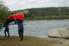
Kathleen and I arrived at Lower Laberge, at the outlet of Lake Laberge, in about an hour. We enjoyed reading about, and strolling through the history of the Thirty Mile River. Dense bush covered the site, which was quite buggy. Also, no firewood. We had made the right choice yesterday to camp near the end of Lake Laberge.


UNADJUSTEDNONRAW_thumb_7a5.jpg - Click image for larger version  Name:	UNADJUSTEDNONRAW_thumb_7a5.jpg Views:	0 Size:	282.4 KB ID:	99832
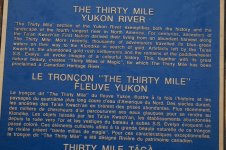
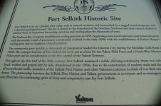
Kathleen at the plaque commemorating the Thirty Mile River as a Canadian Heritage River.


UNADJUSTEDNONRAW_thumb_7a6.jpg - Click image for larger version  Name:	UNADJUSTEDNONRAW_thumb_7a6.jpg Views:	0 Size:	315.0 KB ID:	99834


UNADJUSTEDNONRAW_thumb_7a7.jpg - Click image for larger version  Name:	UNADJUSTEDNONRAW_thumb_7a7.jpg Views:	0 Size:	322.8 KB ID:	99835
Old cabin at Lower Laberge.


UNADJUSTEDNONRAW_thumb_7a8.jpg - Click image for larger version  Name:	UNADJUSTEDNONRAW_thumb_7a8.jpg Views:	0 Size:	306.0 KB ID:	99836
Old truck at Lower Laberge.

After a fairly short visit at Lower Laberge, we headed down the Thirty Mile River, which featured many boils, whirlpools and some riffles. I doubted that the German-With-A-Dream could have paddled this successfully. Tyrell Bend would have been particularly challenging for him. I wondered about what kind of screening process outfitters might use to determine if potential clients like the German had the skills and background to paddle from Whitehorse to Carmacks.

Not our problem, I suppose. Anyway, Kathleen and I had a very enjoyable day of running swift Class I water. We reached Hootalinqua (https://sightsandsites.ca/rivers/site/hootalinqua), the end of the Thirty Mile River, about four o’clock. Two canoes and one kayak belonging to five women had just arrived down the Teslin river, which joins the Yukon here at Hootalinqua. We toured around the historical site, which, like Lower Laberge, did not appeal to us. Dense and buggy. We quickly decided not to stay.


UNADJUSTEDNONRAW_thumb_7aa.jpg - Click image for larger version  Name:	UNADJUSTEDNONRAW_thumb_7aa.jpg Views:	0 Size:	113.5 KB ID:	99837
We beached our canoe at Hootalinqua around four o’clock.


UNADJUSTEDNONRAW_thumb_7ac.jpg - Click image for larger version  Name:	UNADJUSTEDNONRAW_thumb_7ac.jpg Views:	0 Size:	289.6 KB ID:	99838
Covered eating area at Hootalinqua, with trail leading to outhouse.


UNADJUSTEDNONRAW_thumb_7ae.jpg - Click image for larger version  Name:	UNADJUSTEDNONRAW_thumb_7ae.jpg Views:	0 Size:	323.2 KB ID:	99839
Old cabin, old me and new interpretive sign at Hootalinqua


UNADJUSTEDNONRAW_thumb_7af.jpg - Click image for larger version  Name:	UNADJUSTEDNONRAW_thumb_7af.jpg Views:	0 Size:	200.9 KB ID:	99840
History of Hootalinqua telegraph station.


UNADJUSTEDNONRAW_thumb_7b0.jpg - Click image for larger version  Name:	UNADJUSTEDNONRAW_thumb_7b0.jpg Views:	0 Size:	212.9 KB ID:	99841
History of Hootalinqua village.


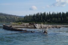
We climbed back into the canoe, and paddled down a few minutes to Shipyard Island, which, according to Rourke, had a “Good Camp.” Rourke didn’t say whether the good camp was at the top or bottom of the island, or on which side of the island. We paddled to the outside of the island, and were sceptical that good camping existed. The island seemed overgrown, and was probably buggy. We paddled slowly, though, and saw what appeared to be an opening, perhaps even a trail into the bush. We stopped, and got out to investigate. We were almost stunned to see an old ship, the steamer Evelyn.

I suppose we shouldn’t have been surprised. After all, the island was named Shipyard (https://sightsandsites.ca/rivers/sit...alinqua-island). And, there was also a picture of the Evelyn in Rourke’s guide book. Nevertheless, we were stunned.

Although Kathleen said the ship was spooky, we set up camp. Rourke indicates that the Evelyn was built in Seattle in 1908, which has been resting here since around 1913. For supper, Kathleen and I enjoyed our usual Friday fare of tuna casserole. Afterwards, Kathleen poured two ounces each of brandy, “In celebration of being on moving water.” We retired to the tent early.


UNADJUSTEDNONRAW_thumb_7b1.jpg - Click image for larger version  Name:	UNADJUSTEDNONRAW_thumb_7b1.jpg Views:	0 Size:	307.0 KB ID:	99842
The steamer Evelyn on Shipyard Island.


UNADJUSTEDNONRAW_thumb_7b2.jpg - Click image for larger version  Name:	UNADJUSTEDNONRAW_thumb_7b2.jpg Views:	0 Size:	295.7 KB ID:	99843
Very spooky, indeed.


UNADJUSTEDNONRAW_thumb_7b4.jpg - Click image for larger version  Name:	UNADJUSTEDNONRAW_thumb_7b4.jpg Views:	0 Size:	324.6 KB ID:	99844
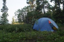
Our camp on Shipyard Island.

Saturday, June 29. Up early, around six-thirty. Cooked our morning bannock on the Coleman Peak 1 back-up stove, which turned out much better than yesterday. I had redeemed myself by serving Kathleen a golden-brown, unburned, canoe-trip breakfast tradition.

As we were beginning to pack up, a power boat passed by only a few metres (yards) off shore. The boat returned only moments later, and four young men straggled onto shore. They had seen the apparent trail into the bush, and, like us yesterday, stopped to investigate. They liked what they saw, and decided to stay for breakfast.

The apparent leader of the group, after all, it was his boat, attempted to move the existing metal fire pit down to the beach. He gave up when he realized the fire pit had been anchored to the ground, probably by the Yukon Government. He looked around for some firewood. I pointed out that Kathleen and I had not been able to find any firewood.

“No problem,” he said, and he headed back to his boat. He returned moments later with a battery-operated chain saw, and headed off into the bush. He returned a few minutes later, dragging a live spruce tree that he then cut into bolts and split into fairly large pieces. He placed several of them, along with some kindling, in the fire pit. He lit the kindling, and stood back quite satisfied. As you might guess, the fire sputtered and went out.

He returned to the boat, and brought back a jerry can, which he shook over the fire pit. Lit the kindling again, and stood back quite satisfied. As you might guess, the fire sputtered and went out. After all, the wood was green.

Never one to give up, he lit the fire again, held the jerry can over the fire, and poured gas on the flame. He kept this up until the flame ran up the pouring river of gas and ignited the jerry can spout.

“You better put the can down. It might explode,” I said. Kathleen, I and his three companions were all a bit wide-eyed. The guy holding the jerry can seemed unperturbed, however. After watching the flame for a few seconds, he pressed the jerry can spout against the arm of his sweatshirt, which extinguished the flame. Too bad Kathleen didn’t have her camera out. The episode would have provided some great images.

The flaming-jerry-can-guy also had brought along his dog, Olaf. We chatted a bit about dogs, and our concern for Shadow back in the Tails and Trails Dog Hotel. “We hope he’s all right,” I said. “He’s afraid of everybody and everything new.”

Flaming-jerry-can-guy opined that Shadow had probably been abused, suggesting that “Dogs are not born timid.” I liked flaming-jerry-can-guy a lot better, now that he had shown empathy for Shadow.

Kathleen and I finished packing up, and prepared to leave. Kathleen visited the outhouse one last time. When she returned to the beach, she said, “Good thing we’re leaving now, Michael. I think they’re planning to have a party. They’re cooking up bacon and eggs, drinkin’ beer and smokin’ marijuana.

A couple of hours later, we approached “Klondike Bend,” where Rourke says the hull of the steamer Klondike #1, built in 1929, can be seen at low water. We paddled to the inside bend to have a closer look. In 1936, with an inexperienced pilot at the wheel, the ship failed to make a bend in the river, and smashed into rocky cliffs at km 154.5 (mile 95),


UNADJUSTEDNONRAW_thumb_7b7.jpg - Click image for larger version  Name:	UNADJUSTEDNONRAW_thumb_7b7.jpg Views:	0 Size:	172.8 KB ID:	99845
Approaching “Klondike Bend”


UNADJUSTEDNONRAW_thumb_7ba.jpg - Click image for larger version  Name:	UNADJUSTEDNONRAW_thumb_7ba.jpg Views:	0 Size:	203.6 KB ID:	99847
before coming to rest here at approximately km 196 (mile 121).

The day was dry and warm, and we drifted leisurely downriver, stopping for lunch on a narrow beach in “Glacier Gulch Bend.” Rourke suggested that this spot provided a “Potential Camp,” but we considered it too overgrown. Besides we weren’t ready to camp yet. As we were packing up, two paddlers with double blades drifted by in solo rafts.


UNADJUSTEDNONRAW_thumb_7bc.jpg - Click image for larger version  Name:	UNADJUSTEDNONRAW_thumb_7bc.jpg Views:	0 Size:	229.9 KB ID:	99848
Lunch on a narrow, gravel beach in “Glacier Gulch Bend”

We also soon drifted on, noting the landmarks detailed in Rourke’s guidebook. “Big Eddy Woodcamp,” where an Eagle sat unflinching at the top of a spruce tree despite being harassed by a pair of swooping and diving Ravens. Then “Upper Cassiar Bar,” which begins a stretch of the river where gold was discovered in 1886. A party of four men was reported to have taken out $6,000.00 in only thirty days.


UNADJUSTEDNONRAW_thumb_7bf.jpg - Click image for larger version  Name:	UNADJUSTEDNONRAW_thumb_7bf.jpg Views:	0 Size:	179.3 KB ID:	99849
View toward Big Eddy Woodcamp.


UNADJUSTEDNONRAW_thumb_7c2.jpg - Click image for larger version  Name:	UNADJUSTEDNONRAW_thumb_7c2.jpg Views:	0 Size:	179.2 KB ID:	99850
View toward “Upper Cassiar Bar”

Just before the Big Salmon River, we pulled out on river right to inspect a spot that Rourke listed as “Good Camp,” with “Cabin Good Condition.” It was more than a good
camp—it was a great camp. It also featured an outhouse? Although early in the day, a little before three o’clock, we decided to stay, and relaxed on shore, watching the Yukon River roll on by.

As we were setting up, we saw four tandem canoes approaching. I stood on the bank, making myself very visible, hoping they would stop. The Yukon River is very popular. We expected to see people everyday. We were actually looking forward to meeting other paddlers. Looking forward to sharing stories, not only of the Yukon River, but also of previous wilderness adventures.

The first two boats paddled by without even slowing down. Two bad. It would have been nice to have visitors for at least an afternoon. Suddenly, the bowsman in the lead boat yelled out, “Do you mind if we camp behind?”


UNADJUSTEDNONRAW_thumb_7c3.jpg - Click image for larger version  Name:	UNADJUSTEDNONRAW_thumb_7c3.jpg Views:	0 Size:	249.1 KB ID:	99851
Kathleen relaxing on shore, watching the Yukon River roll on by.


“Not at all. It’s a large camp. Plenty of room for everybody. We would enjoy the company.”The two leading canoes worked hard to paddle back up against the current, but eventually all eight of our visitors stood on the beach. The bowsman in the first boat introduced himself.

“I’m Rainer Russmann, I’m the owner of Yukon Wild, and I’m leading this group on a guided canoe trip. We had been intending to camp here, as it’s great camp. But when I saw you, I thought that we shouldn’t. My policy is to never bring one of my larger groups into a camp that’s already occupied by only a small group. But it’s such a great camp, and my people had been looking forward to stopping. I hope that you really don’t mind.”

“Not at all,” I said. “We’re glad you stopped. I was just getting ready to carry my canoe higher up the bank above the river. Do you think you could give me a hand?"

“Use me,” Rainer said, as he and another guy grabbed my canoe and carried it up the bank.

Can you guess which one of the people in the image below is Rainer, the guide? Pretty obvious, isn’t it? Rainer’s group included four Germans, one Swiss and two Englishmen. They had begun their trip at Johnson’s crossing, on the Teslin River. From there, they paddled 185 km (115 miles) down the Teslin River to its confluence with the Yukon River at Hootalinqua. Many groups select this route to avoid the much-ballyhooed terrors of Lake Laberge. They planned to end their trip at Carmacks.

We asked Rainer about his industry’s approach to people like the German-With-A-Dream. “What do you do when people come to you, wanting to rent a canoe, and head off by themselves down the Yukon River? Do you try to assess their skills?”

“No. It’s like if someone shows up to a car rental place with a driver’s license, and wants to rent a really hot car, you rent it to him. I wouldn’t ask him if he can handle such a car. It’s his own fault for not being aware of his limitations. I have no sympathy for him. It was his choice.”


UNADJUSTEDNONRAW_thumb_7c5.jpg - Click image for larger version  Name:	UNADJUSTEDNONRAW_thumb_7c5.jpg Views:	0 Size:	301.1 KB ID:	99852
Rainer, seated far right, and his guided trip, just before the Big Salmon River

Kathleen and I also wondered if they had seen the flaming-jerry-can-guy. We hadn’t seen them all day. They had a power boat, and should have caught us by now.

“Well, we heard them at Shipyard Island. Music blaring away. We didn’t stop.”

As you might have anticipated, I also asked Rainer about Five Finger Rapids. He said, “Just stay right.” We chatted about some of our other wilderness trips. Rainer, Kathleen and I had all done the South Nahanni River.

“Where’d you put in, Rainer?”

“At Rabbitkettle Lake. We didn’t have enough time to start at the top, at the Moose Ponds.”

“When Kathleen and I did the Nahanni with two other couples, we started at the Moose Ponds. We scouted the first rapid in the Rock Gardens, but then just ran down the rest of them.”

Rainer’s eyes actually got big. “You ran the Rock Gardens, and you’re worried about Five Finger Rapids? You should be leading trips through Five Finger Rapids.”

Maybe, I thought to myself. But I’m a lot older now. I’ll be 72 in a couple of months. And Five Finger Rapids has a name. You always gotta worry about rapids that have a name. The Rock Gardens had a name, and they were quite challenging. (Note: For those of you who might not know, the Rock Gardens are two-and-a-half days of essentially continuous whitewater, with rapids up to Class IV.)

“Our favourite trip, Rainer, was the Thelon River in 1993. Just Kathleen and me. Thirty-seven days and 950 km (590 miles) from Lynx Lake to Baker Lake. We loved the Barren Grounds.”

Rainer’s eyes got big again. “I’ve always wanted to do the Thelon. But I don’t think I’ll ever have enough time.”

I contemplated telling Rainer that Kathleen and I had self-published a book about our Thelon River trip. A compilation of our diaries. But I never like to promote myself. I should have mentioned something. He might have enjoyed our book.

There was no firewood around our well-used camp, but Rainer brought a small handsaw. His group scurried about, and soon had a fire going, which we used to cook our quesadilla. Rainer pretty much did all the work preparing his group’s supper. Maybe Kathleen and I should consider booking a guided trip next summer. It’s so expensive, though. Maybe I’m not quite lazy or old enough yet. And besides, what if I didn’t get along with the rest of the group? Sometimes I’m not all that likeable myself.

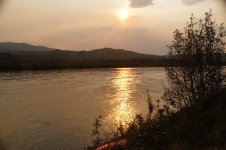
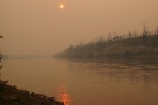
Except for that first day on Lake Laberge, we had generally enjoyed warm, calm sunny, worry-free weather. But forest fires were burning out there somewhere. As Kathleen and I prepared for bed around ten o’clock, smoke began to fill the Yukon River valley.


UNADJUSTEDNONRAW_thumb_7c6.jpg - Click image for larger version  Name:	UNADJUSTEDNONRAW_thumb_7c6.jpg Views:	0 Size:	242.8 KB ID:	99853
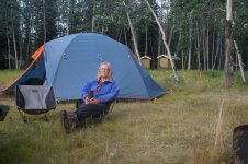
Me and Kathleen lazing about, watching Rainer do all the work.


UNADJUSTEDNONRAW_thumb_7c8.jpg - Click image for larger version  Name:	UNADJUSTEDNONRAW_thumb_7c8.jpg Views:	0 Size:	338.5 KB ID:	99854
Preparing for bed, just before ten o'clock.


UNADJUSTEDNONRAW_thumb_7c7.jpg - Click image for larger version  Name:	UNADJUSTEDNONRAW_thumb_7c7.jpg Views:	0 Size:	198.5 KB ID:	99856
Smoke from forest fires begins to fill the Yukon River valley.


Sunday, June 30. I slept until seven-thirty. Ash from the forest fires had coated our tent fly overnight. Rainer already had the fire going, and I used it to heat tea water for Kathleen and me. Pretty nice to have someone like Rainer doing all the work.

Rainer’s group soon began to cluster around the fire to toast bread on the grate. There was no room to cook my bannock. Rainer noticed the bannock mixture in my pan.
“Would you like more space on the fire?”

“I can wait, Rainer, It’s your fire.”

“No. It’s our fire,” he said.” With that, Rainer rearranged the toasting bread to give me enough room to cook our traditional morning bannock.

One of the Englishmen in Rainer’s group had been working for a media company in Hong Kong for five years,. He said that “I’ve always heard that Canadians love bannock, and finally I get to see how it’s done.”

The whole group gathered around to watch me cook our morning bannock. Lots of audience pressure on me, but I was up to the task. Our bannock came out golden brown on both sides. The audience didn’t cheer or clap after my performance, but I think they should have.

If you look back at the image of Rainer’s group, you will note the lady on the left, and her husband seated to her left. After ending their trip at Carmacks, this German couple intended to head back to Whitehorse. From there, they planned to rent a canoe from Rainer, and paddle by themselves down to Dawson City. “We have to do the whole thing, don’t we? ” she asked. I agreed. You gotta do the whole thing.

I must point out, however, that the Yukon River is the third longest river in North America, flowing 3,190 km (1,980) miles from its source in British Columbia to the Bering Sea in Alaska. The 715 km (443 miles) between Whitehorse Dawson City can not truly be considered the “whole thing.” Most people, though, associate the Yukon River with the history of the 1898 Klondike gold rush, which occurred primarily between Whitehorse and Dawson City. From that perspective, the stretch from Whitehorse to Dawson City constitutes the “whole thing.” (Note: Some references consider the Mackenzie River to be longer, depending on where one decides the Mackenzie actually begins.)

Reminders of the history of the Klondike gold rush were common throughout our trip. This sign stood immediately across the river from our shared camp with Rainer’s group. It reads: This N.W.M.P. detachment, named for the nearby Big Salmon River, was one of several established in 1898 at 50 to 65 km along the Yukon River. From the Chilcoot Pass to Dawson City, the “Mounties” kept order and assisted 30,000 Klondike gold-seekers. The telegraph station built in 1890 still stands. But little is left of the police post, which closed in 1901. The sign is severely out of date, however, as Rourke indicates that a 1995 wildfire completely destroyed the telegraph office.


UNADJUSTEDNONRAW_thumb_7cd.jpg
Big Salmon Northwest Mounted Police Post

Kathleen and I prepared to put on the water a little before ten. I was disappointed to discover that the bow bungee cord had been snapped in two. Must have happened when Rainer and another guy in his group moved my canoe higher up the bank for me. Some people don’t really know how to pick up canoes. You’re supposed to use the thwart or grab loop, not the bungee cord. Not a big deal, though. I simply tied it back together. Still, it would have been nice if the person wanting to help me had just mentioned the accident.

About 15 years ago, at the beginning of a weekend trip with a new group, I was about to throw my canoe up onto my shoulders to carry it to the water. Suddenly, without asking, a guy rushed over to help. He picked up the canoe, not by the thwart or grab loop, but by the wooden deck, which immediately cracked. He looked at me, but didn’t say a thing. Probably thought I wouldn’t notice. These are the only two times that strangers have ever helped me move my canoe, and both times damage resulted. Might be an obvious moral to this story.


UNADJUSTEDNONRAW_thumb_7cb.jpg
Morning camp after breakfast. Russ Giesbrecht, an active trapper, maintains this “Cabin Good Condition.”


UNADJUSTEDNONRAW_thumb_7d3.jpg


Anyway, Kathleen and I laced up the spray deck, and headed downriver, intending to reach the Mandanna Creek campground, about 70 km (45 miles) away, just north of the Little Salmon River. Both Rainer and Rourke recommended it as a “Good Camp.”

About two hours later we stopped for a pleasant chat with the two solo rafters that we had seen during yesterday’s lunch break. A German guy living in Vancouver with his Russian girlfriend. He said he had never met anyone before from Saskatchewan while paddling on northern Canadian rivers. As it turns out, neither had we. In fact, nearly all of the other paddlers that Kathleen and I had ever seen on wilderness trips were non-Canadian, most often German. We mentioned that Rainer was German, with two Englishmen, four Germans and one young Swiss woman in his group.

“Did she speak German?” he asked.

“I think so.”

“Well, they might not agree, but if you speak German, you’re German.”

Don’t know what that means, really. Don’t even know how to analyze it.

A few minutes after putting back on the water, a strong north wind sprang up to blow directly at us. Whitecaps on the river. No fun at all. Very hard work. The calmest conditions were on the inside bends, but the fastest current was on the outside bends. I tried to select a route that optimized the trade off between these two choices. I thought of The German-With-A-Dream, who had paddled only on lakes, and had heard that the Yukon had no rapids. I don’t think he could have handled this solo, with his limited skills. heck! We were having a tough time. Kathleen seemed frustrated

“I never expected to have to paddle hard for two weeks, and 700 km (435 miles). to Dawson City.” (Note: Kathleen didn’t actually refer to the miles in her statement. I put that in there for those of you who might prefer imperial units.)

Indeed, we had both expected a leisurely float to Dawson City. I had told yellowcanoe that we planned 15 days to reach Dawson City from Whitehorse. She said that it would take us 15 days if we did a lot of back paddling. This was not what I was expecting when I was saving the Yukon for when I got old. This is not what I expected when yellowcanoe wrote that the Yukon is a seniors’ river.

Well, you get what you get, and we got even more wind. After lunch, a strong gust blew my Tilley hat off. I had forgotten to reset the chin strap. As you might know, Tilley hats float because of a little piece of foam inserted into a sleeve. We chased the hat downriver, bracing against conflicting currents and winds, and finally caught it. A near catastrophe. I gotta have my Tilley hat. I’m bald, and burn easily. I do always take a spare baseball cap just in case, but it’s not as protective as my Tilley hat.

Just before the confluence with the Little Salmon River, we were ferrying over to river right. Strong current pushed us downriver. Strong wind pushed us back up. I felt vulnerable in the middle of the wide Yukon River. I yelled out to Kathleen. “I hate this.” I should have said so sooner. Ten minutes later the wind subsided.

Rourke’s book has been fantastic. Lots of historical information, plus indications of good campsite locations. Compared to most of our previous wilderness trips, Kathleen and I considered the camping in this section of the river to be poor. Bush right down to the river. Limited gravel bars. Very little driftwood. Rourke’s book is a must for this stretch of the Yukon River.

We reached Mandanna Creek camp at six-thirty. Pretty good considering all the headwind. We enjoyed a gorp snack on the beach before setting up camp. At 8:00 p.m., a solo kayak and a tandem canoe from the Up North outfitters paddled by, enveloped in smoke. They didn’t slow down. Maybe they intended to reach Coal Mine Campground, only about 40 km (25 miles) away for burgers and booze tonight. Kathleen poured two ounces of brandy for our pre-supper celebration. So far, the Yukon River had not been a “float.” Maybe soon. After brandy, we dined on smokies and beans for supper.

Smoke now filled the Yukon River valley. We wondered how close the forest fires might be.


UNADJUSTEDNONRAW_thumb_7d7.jpg
Smoke from forest fires filled the valley at Mandanna Creek camp.
 

Attachments

  • UNADJUSTEDNONRAW_thumb_7a6.jpg
    UNADJUSTEDNONRAW_thumb_7a6.jpg
    315 KB · Views: 0
  • UNADJUSTEDNONRAW_thumb_7ba.jpg
    UNADJUSTEDNONRAW_thumb_7ba.jpg
    203.6 KB · Views: 0
  • UNADJUSTEDNONRAW_thumb_7c7.jpg
    UNADJUSTEDNONRAW_thumb_7c7.jpg
    198.5 KB · Views: 0
  • UNADJUSTEDNONRAW_thumb_7d7.jpg
    UNADJUSTEDNONRAW_thumb_7d7.jpg
    83.7 KB · Views: 0
Last edited:
Nice one again!! We like tow-end more time on the Thirty Mile, usually we do a 2 nighter there it is so pretty, my favourite part of the Yukon river for sure!
 
Good for you PP! We sat at Hootalinqua with way too many people and missed the shipwreck entirely by paddling on the inside of the Shipwreck Island.. Thanks for the pics to fill in our blindness!
Folks this trip really is as good as it looks.
 
Lotsa memories there!
You write a very nice trip narrative....well done!

Not sure what's in store for this summer.....Pelly?......Salmon?....Scottie Creek/Chisana?
 
Monday, July 1. Up at seven-thirty. Cooked a slow, languorous bannock. Rainer and his group arrived at 10:15 a.m., just as we were getting ready to depart. One of the Germans was fanatic about fishing. Had to catch at least one fish every day. While he was fishing in Mandanna Creek, I mentioned to Rainer that Kathleen and I had written a book about our Thelon River trip.

“I’d love to have a copy. Would you send one to me when you get home?”

“Sure, Rainer. I’d be glad to. But it’s not high adventure, or deep literature. It’s just our diaries.”

Kathleen shushed me. She doesn’t like me to be so apologetic about our book. But that’s just the way I am.

The must-catch-a-fish-every-day-German returned a few minutes later displaying a large pike. We chatted about the wind yesterday. They didn’t like it any more than we did, and had stopped short of their day’s goal. Rainer said that he was glad to have come across us on the river.

“It’s good for my clients to know that Canadians actually do paddle northern rivers. They usually see just non-Canadians, like themselves.”


UNADJUSTEDNONRAW_thumb_7dc.jpg - Click image for larger version  Name:	UNADJUSTEDNONRAW_thumb_7dc.jpg Views:	0 Size:	329.7 KB ID:	99863
Breaking camp at Mandanna Creek


Kathleen and I put on the water at ten-thirty, and stopped for lunch at one-thirty at Rourke’s “Good Camp.” We saw our first campable gravel bar, with driftwood, about an hour before Coal Mine Campground. That was encouraging, as it held promise that we might be able to use wood for cooking rather than our limited supply of white gas.

Rain and strong wind pounded us the last hour before Coal Mine Campground. We were both becoming weary of the constant struggle, and were glad to finally arrive around three in the afternoon. Four people, with one large, nervous dog, were on the dock, loading their tandem canoes. They paddled away very precariously, stroking tentatively, with the nervous dog jumping back and forth. I hoped they would make it through Five Finger Rapids.

Kathleen and I then headed for the showers. Six minutes for only three dollars. Luxurious. We also put our dirty clothes in the washing machine. Wonderful. It was like starting our Yukon River wilderness trip all over again.

Feeling clean and refreshed, Kathleen and I stood in line for wine, burgers and fries. I asked the young man if we could drink our wine in the campground. He seemed surprised by the question, and said, almost derisively, “You can drink your wine wherever you want.”


UNADJUSTEDNONRAW_thumb_7de.jpg - Click image for larger version  Name:	UNADJUSTEDNONRAW_thumb_7de.jpg Views:	0 Size:	197.9 KB ID:	99864
Showered and refreshed, enjoying wine and burgers at the Coal Mine Campground.

The campground had cellular access. So do you know what Kathleen did next? Yep. That’s right. She emailed the Tails and Trails Dog Hotel: “Hi, Nina. I know this is a holiday (It was Canada Day), but we are at Carmacks overnight and have cell service so are wondering how Shadow is doing.”

Nina responded one hour and 57 minutes later: “Hi Kathleen. Shadow is doing fantastic, he is a very pleasant guest at the hotel! He is totally relaxed, runs and plays with the other dogs, it’s pretty amazing and wonderful to see! Have a great further trip!” Best of all, Nina also included a photo of Shadow in her email!


UNADJUSTEDNONRAW_thumb_989.jpg - Click image for larger version  Name:	UNADJUSTEDNONRAW_thumb_989.jpg Views:	0 Size:	119.0 KB ID:	99865
Shadow running with his new friends at the Tails and Trails Dog Hotel.


Now only two things to worry about. Will we be able to run Five Finger Rapids, and will the van be able to get us home to Preeceville?

Kathleen had also received a text message from our friend Marilyn, in Prince Albert, saying that her dog, Cinder had died. Brought tears to my eyes.

Afterwards we strolled around the camp, and down to the dock, where we met two young women who had just completed the Yukon River Quest. They looked so relaxed and vibrant.

“So, I was wondering,” I said. “The race is pretty much non-stop for extended periods of time. What do you do if you have to go to the bathroom?”

“We have a pee bottle, Easier for guys than us, though.”

Fair enough; but, I was curious about more substantial aspects of “going to the bathroom.” I had heard that some Questers wear diapers. I dropped the subject, though, as perhaps being too personal. Nevertheless, I remained curious.

I also had to ask them,“How was Five Finger Rapids?”

“It was flat. Low water this year. As always, we just stayed right.”

I then walked back up to the concession stand to see if they sold white gas. They didn’t. Eight days to go until we reach Dawson City, with only four-and-a-half days of fuel left. We need to camp where firewood is available.

Kathleen and I retired to the tent early. We would reach Five Finger Rapids tomorrow. It should be OK.

Tuesday, July 2. We rose early, and headed to the concession stand to buy breakfast sandwiches, a black coffee for me, and a latte for Kathleen. I asked the campground owner, who also took orders, if he knew where the fires were.


UNADJUSTEDNONRAW_thumb_7e1.jpg - Click image for larger version  Name:	UNADJUSTEDNONRAW_thumb_7e1.jpg Views:	0 Size:	227.5 KB ID:	99866
“The fire is 27 km (17 miles) south of Dawson City, but not near the river.” That was good news. There were times that Kathleen and I wondered if we would have to flee a fire pouring over the ridge. It seemed not.

The Coal Mine Campground was for sale. Business seemed very good.

“So why are you selling?” I wondered.

“Very difficult to find enough staff out here who want a job. They say, why should I work hard for $800.00 a month, when I can do nothing and get $500.00 a month from the government.”

“I guess I can only speak for me, but I would rather get more money and have something to do.”

“Well, make an offer on my place. Buy yourself a full-time job.”

“Sorry. I don’t need a job.”

We strolled back to our picnic table to enjoy breakfast, when out of nowhere, Kathleen said, “I gotta take a picture of my handsome husband.”


UNADJUSTEDNONRAW_thumb_988.jpg - Click image for larger version  Name:	UNADJUSTEDNONRAW_thumb_988.jpg Views:	0 Size:	132.9 KB ID:	99867
Kathleen enjoying her morning latte at the Coal Mine Campground

Kathleen and I have been married since 1981, and she had never before called me her handsome husband. She might have been thinking it. Probably was. So what prompted this sudden outburst of admiration, you might ask? Well, I hadn’t shaved since leaving Whitehorse, and it seems that Kathleen approved of the stubble look. This could mean more grooming work for me when we return home to Preeceville. Well worth it, though, to retain my new status as Kathleen’s handsome husband.


UNADJUSTEDNONRAW_thumb_7e0.jpg - Click image for larger version  Name:	UNADJUSTEDNONRAW_thumb_7e0.jpg Views:	0 Size:	150.4 KB ID:	99868
No time to bask in my apparent physical charms, though. We needed to get paddling. We broke camp and lugged our gear down to the dock. It didn’t take us long to load the canoe and lace up the spray deck. We were on the water at 9:00 a.m., and headed down the Yukon River for today’s appointment with Five Finger Rapids.


UNADJUSTEDNONRAW_thumb_7e5.jpg - Click image for larger version  Name:	UNADJUSTEDNONRAW_thumb_7e5.jpg Views:	0 Size:	184.9 KB ID:	99869
Preparing for today's appointment with Five Finger Rapids.


The day was calm, and reasonably sunny. Still smoky, though. We followed Rourke’s schematic maps closely all morning. We stopped for a snack at Murray Creek, and confirmed our position with the GPS. Back in the canoe, we paddled on, looking for the islands where we would lunch, and prepare for Five Finger Rapids. And then, the highway appeared on river right, with vehicles parked at the lookout point above Five Finger Rapids.

We pulled out on river left, and hiked 100 m (100 yards) around the bend to look directly into Five Finger Rapids. Along the way, we found a Carlyle paddle lodged between some boulders. Good luck, indeed; but, we were on the wrong side of the river. While we contemplated Five Finger Rapids, a tandem canoe headed down the right bank, and entered the far right finger of the rapid, just like one is supposed to do. As everyone says, “Just keep right.”


UNADJUSTEDNONRAW_thumb_7e9.jpg - Click image for larger version  Name:	UNADJUSTEDNONRAW_thumb_7e9.jpg Views:	0 Size:	149.2 KB ID:	99872
Viewing Five Finger Rapids from river left.

Back in the canoe, we tightly secured our spray skirts. We pointed the canoe upstream for a long and necessary ferry to river right. We made strong strokes with our whitewater paddles, and were actually going up river. My mouth dried, as it always does when I’m worried in the canoe; but, the ferry went very well.


UNADJUSTEDNONRAW_thumb_7ec.jpg - Click image for larger version  Name:	UNADJUSTEDNONRAW_thumb_7ec.jpg Views:	0 Size:	129.8 KB ID:	99873
Just staying right as we approach Five Finger Rapids

We turned down when we neared the right bank, and entered the far-right finger. The waves were flat, just as the young women told us yesterday at the Coal Mine Campground.

We pulled out a few hundred metres (yards) later to rest and to have lunch. The run through Five Finger Rapids had been very anti-climatic. In fact, Kathleen and I were both disappointed. Even so, Kathleen had yelled out “Yeehaw” at the bottom of the run. “You’re supposed to say that, aren’t you Michael? Everyone that we’ve seen in the videos has yelled out yeehaw.” Kathleen took the image above of us approaching Five Finger Rapids at 2:08:59. She took the image below of me having lunch on the beach only one minute and 41 seconds later, at 2:10:40. So we were actually in Five Finger Rapids probably no longer than 30 seconds. All that worry for nothing.


UNADJUSTEDNONRAW_thumb_7ed.jpg - Click image for larger version  Name:	UNADJUSTEDNONRAW_thumb_7ed.jpg Views:	0 Size:	308.9 KB ID:	99875
Anyway, yesterday we learned that Shadow was happy at the Tails and Trails Dog Hotel. Today we learned that Five Finger Rapids was easy. Only one worry left: will the van be able to get us home to Preeceville? We won’t know the answer to that question until we start driving south in about a week from now.

Back on the river, the headwinds renewed their unwelcome assault. We soon reached Rink Rapids, which, as Carol and others had said, seemed to stretch all the way across the river. We kept going right, though, as recommended, and found lots of open water. Without Carol’s advice, we likely would have stopped to scout. Rink Rapids did look a trifle ominous from above.

I paddled with my newly-found Carlyle paddle for about 90 minutes. Didn’t like it at all. The T-grip was uncomfortable, and the paddle itself was somewhat heavy. Not suitable for relaxed, calm paddling. And not as effective as our Harmony Perception paddles for whitewater. In fact, the Carlyle paddle didn’t differ noticeably from our inexpensive, entry-level Mohawk paddles, and we never use them anymore.

Today’s destination was Yukon Crossing, where Rourke said we would find an outhouse and “Good Large Camping Area Behind Stable.” Sounded good to us. A few minutes before five o’clock, we beached the canoe where we thought Yukon Crossing should be. But there was nothing. Maybe we were not where we thought we were. That has certainly happened before. I took a GPS reading, and confirmed that we were exactly where we should be. But no Yukon Crossing. What’s going on here?

We climbed back into the canoe and paddled a few more strokes, and noticed a barely perceptible path up the bank. We stopped and forced our way through the bush into a “clearing” of tall grass, decaying buildings, and informational signs. The site was very closed in, dank and somewhat oppressive. The campsites were relatively far from the river.


UNADJUSTEDNONRAW_thumb_7f0.jpg - Click image for larger version  Name:	UNADJUSTEDNONRAW_thumb_7f0.jpg Views:	0 Size:	311.9 KB ID:	99876
The sign reads: Winter travel from Dawson City to Whitehorse was initially along the frozen Yukon River. Increased traffic led to the replacement of the traditional dogsled with horses but travel on the ice was hazardous. The building of the Overland Trail in 1902 shortened the trip by 160 km. The wagon road crossed the Yukon River at MacKay's Roadhouse, using either horse-drawn sleighs or ferries. "McKay's Crossing" eventually became Yukon Crossing.


UNADJUSTEDNONRAW_thumb_7f1.jpg - Click image for larger version  Name:	UNADJUSTEDNONRAW_thumb_7f1.jpg Views:	0 Size:	310.6 KB ID:	99877
Decaying building at Yukon Crossing.


We didn’t like Yukon Crossing, and paddled on for about another 10 km (six miles) to Merrice Creek. A narrow trail from the beach led to a nice campsite. We moved in. We were satisfied with today’s progress. By six o’clock, we had covered about 65 km (40 miles), leaving only about another 65 km to Fort Selkirk, tomorrow’s destination.

For supper, Kathleen cooked Shepherd’s pie on the Coleman Peak 1 stove. Our meal was very nicely complemented by white wine left over from last night. We both wondered why we hadn’t bought another bottle to bring with us from Coal Mine Campground. Before bed, we scrounged enough firewood to cook tomorrow morning’s bannock.

The wind stopped at 8:30 p.m. An hour later, the sky cleared, the sun appeared and the Yukon River valley glowed in the evening light.


UNADJUSTEDNONRAW_thumb_7f4.jpg - Click image for larger version  Name:	UNADJUSTEDNONRAW_thumb_7f4.jpg Views:	0 Size:	226.9 KB ID:	99878
Camp at Merrice Creek.

Wednesday, July 3. Up a little before eight. Could have easily slept more. Don’t really know why I didn’t. There was no imperative to get up. We didn’t have any meetings to attend. Nowhere to be at a specific time. But there you have it. I was up a little before eight.


UNADJUSTEDNONRAW_thumb_7f5.jpg - Click image for larger version  Name:	UNADJUSTEDNONRAW_thumb_7f5.jpg Views:	0 Size:	306.2 KB ID:	99879
I then started the fire, and leisurely cooked our bannock breakfast. Good to have a fire, not only for its cheery warmth, but also because we didn’t have to dip into our precious supply of white gas.

There are a variety of decaying buildings at Merrice Creek. According to Rourke one of the cabins was “constructed from wrecked steamer materials and a door made from the sign that once adorned the (nearby) Williams Creek Copper mine headquarters. Trails led to more cabins and mine shafts. A person could have spent an enjoyable day here just investigating and exploring.


UNADJUSTEDNONRAW_thumb_7f7.jpg - Click image for larger version  Name:	UNADJUSTEDNONRAW_thumb_7f7.jpg Views:	0 Size:	341.8 KB ID:	99880
Decaying cabin at Merrice Creek


UNADJUSTEDNONRAW_thumb_7f8.jpg - Click image for larger version  Name:	UNADJUSTEDNONRAW_thumb_7f8.jpg Views:	0 Size:	219.8 KB ID:	99881
Door salvaged from nearby Williams Creek Copper mine headquarters.


We put on the water at little after ten-thirty, our latest start so far. Moments later, we drifted past deposits of ash. The following information is taken from the whatsupyukon.com website. Within the Wrangell Mountains of Alaska, just 40 kilometres west of the Yukon–Alaska border, south of Beaver Creek, are two mountains—Churchill and Bona. Bona-Churchill is a volcano. There are two known eruptions: the first occurred around 150–500 AD; and the younger and much larger one, about 800 AD. At the time of the first eruption, the prevailing wind was from the south. The eruption blew volcanic ash high into the sky and it was carried downwind. Fallout from this plume can be traced straight north along the Alaska–Yukon border. In the Dawson–Eagle area, there is a layer of ash about three centimetres thick. It is over seven centimetres thick near Snag, Yukon, and thicker near the source.

The younger, second eruption was estimated to be about five-times larger than the first one. The winds at that time were coming from the west. Ash is visible all the way between Mayo, in the north, to the British Columbia border, in the south, and past the Northwest Territories–Yukon border in the east. Around Whitehorse, you can find between two to three centimetres of ash.

There were people living in the immediate area of the eruption and in the southern Yukon, in general. Indigenous Peoples had been living in the area for thousands of years. Ancestors of today’s Tutchone people were right in the path of the worst of the ash cloud. That period still exists in the oral tradition of the Indigenous Peoples of southern Yukon. It is estimated that the number of people directly affected was several hundred.

Archaeologists and Indigenous Peoples from western North America have long recognized the similarity of the languages of the Navajo, in the southwest, to the Athapaskan languages of northern Canada. It is thought that when people were driven out of the southern Yukon, due to the eruption, one group of people headed directly to the coast in Alaska and British Columbia, and another group headed south to a new land in the dry interior of southwestern United States.


UNADJUSTEDNONRAW_thumb_7f9.jpg - Click image for larger version  Name:	UNADJUSTEDNONRAW_thumb_7f9.jpg Views:	0 Size:	302.1 KB ID:	99882
Volcanic ash from approximately 800 AD. https://whatsupyukon.com/Yukon%20Out...ion-next-door/


Headwinds began about 15 minutes later. Kathleen and I struggled all day. In the late afternoon we just wanted a simple beach to stop and stretch our legs. But no such simple beach presented itself, and we continued to paddle until we approached Fort Selkirk at about six-thirty.

UNADJUSTEDNONRAW_thumb_7fb.jpg - Click image for larger version  Name:	UNADJUSTEDNONRAW_thumb_7fb.jpg Views:	0 Size:	142.3 KB ID:	99883
Approaching Fort Selkirk.


Seven canoes from the Ruby Range Adventure company lay secured, and lined up on the beach. Kathleen and I carried our first load of gear up a steep, partially broken flight of stairs up to a very nice campsite. On our second trip up from the beach, a woman from Toronto, Margo, if I remember correctly, lugged up one of our smaller packs. We much appreciated her help.

Fort Selkirk is now a National Historic Site, co-owned and co-managed by the Selkirk First Nation and the Yukon Government. Robert Campbell, of the Hudson Bay Company, established Fort Selkirk at the present location of the townsite. In 1852, the post was looted and burned by the Chilkat people. Over the subsequent years, a variety of enterprises and activities occurred here, until the riverboats stopped running in the early 1950s. After that, residents packed up and moved primarily to Pelly Crossing, Minto and Carmacks, which were all located on the newly constructed Klondike Highway. Today, the abandoned settlement is gradually being restored through government funding.


UNADJUSTEDNONRAW_thumb_7fd.jpg - Click image for larger version  Name:	UNADJUSTEDNONRAW_thumb_7fd.jpg Views:	0 Size:	236.5 KB ID:	99887


UNADJUSTEDNONRAW_thumb_80b.jpg - Click image for larger version  Name:	UNADJUSTEDNONRAW_thumb_80b.jpg Views:	0 Size:	318.7 KB ID:	99888
Our camp at Fort Selkirk.


UNADJUSTEDNONRAW_thumb_91a.jpg - Click image for larger version  Name:	UNADJUSTEDNONRAW_thumb_91a.jpg Views:	0 Size:	265.5 KB ID:	99889
The Ruby Range Adventure group invited us to share their fire to cook our spicy Thai Noodle supper. Volunteers at the historical site provided free firewood. Great news for us. Another day of preserving our limited supply of white gas.

I chatted with Christine, the group leader. Originally from Germany, Christine now lived in Whitehorse, and said that she had never seen such persistent, unyielding wind on the Yukon River. She asked where Kathleen and I had begun our day.

“Merrice Creek.”

“Long way,” she said.

It seemed like a long way for Kathleen and me, particularly with that headwind. About 70 km (45 miles).

I mentioned the German-With-A-Dream.

“All by himself. He couldn’t keep the canoe going straight. Always switching sides every two or three strokes. I worried about him. I hope it turned out OK.”

Like Rainer, Christine said “It’s his own fault. He’s his own responsibility. But you know, switching sides is not necessarily bad. I lead these trips solo, and I switch sides.”

“Well, I haven’t seen you paddle, but you’re probably using the sit-and-switch method, like marathon racers. The German-With-A-Dream was trying to correct with goon strokes, but just didn’t have the skills. I doubt that he had ever heard of sit-and-switch. But I take your point.”


Click image for larger version  Name:	UNADJUSTEDNONRAW_thumb_801.jpg Views:	0 Size:	184.2 KB ID:	99891
There are no roads to Fort Selkirk, which can be reached only by boat.


I asked Christine about the Yukon River Quest.

“I have heard that some of the Questers wear diapers and catheters. Is that really true?”

“Well, we showed up at Coal Mine Campground, the day after they left. People we talked to said that the camp was a fetid mess from all the garbage and diapers.” (Note: The Questers are required to rest at Coal Mine Campground for a minimum of seven hours. This was likely the first stop for most of them since leaving Whitehorse. I still don’t actually know if any Questers wear diapers. But if they do, that’s certainly a tremendous commitment to winning the race. As for me, I intend to delay as long as possible the day I have to start wearing diapers again.)

I asked Christine about her approach to leading canoeists, many of which were likely beginners, through Five Finger Rapids.

“Some guides group up in the large eddy above the rapids. I like to just line them up like ducklings, and through we go.”

“I would do it the same way, Christine. If everyone is already together on the river, and lined up properly, going to shore could just re-introduce problems.”

After supper, Kathleen and I strolled around the National Historic Site of Fort Selkirk. During the day, First Nation’s guides are often available for free tours. But it was already eight o-clock, so we just showed ourselves around. All the buildings were kept unlocked, so we could just go in and reflect on the past.


UNADJUSTEDNONRAW_thumb_7ff.jpg - Click image for larger version  Name:	UNADJUSTEDNONRAW_thumb_7ff.jpg Views:	0 Size:	185.7 KB ID:	99893
Looking south, up the Yukon River.


UNADJUSTEDNONRAW_thumb_805.jpg - Click image for larger version  Name:	UNADJUSTEDNONRAW_thumb_805.jpg Views:	0 Size:	212.0 KB ID:	99894
Taylor & Drury general store.


UNADJUSTEDNONRAW_thumb_802.jpg - Click image for larger version  Name:	UNADJUSTEDNONRAW_thumb_802.jpg Views:	0 Size:	304.0 KB ID:	99895
Riverfront view, Fort Selkirk.


UNADJUSTEDNONRAW_thumb_806.jpg - Click image for larger version  Name:	UNADJUSTEDNONRAW_thumb_806.jpg Views:	0 Size:	215.2 KB ID:	99896
Riverfront view, Fort Selkirk.


UNADJUSTEDNONRAW_thumb_807.jpg - Click image for larger version  Name:	UNADJUSTEDNONRAW_thumb_807.jpg Views:	0 Size:	297.2 KB ID:	99897
Me hanging out in Fort Selkirk.


UNADJUSTEDNONRAW_thumb_804.jpg - Click image for larger version  Name:	UNADJUSTEDNONRAW_thumb_804.jpg Views:	0 Size:	169.3 KB ID:	99898
Fort Selkirk school room.


UNADJUSTEDNONRAW_thumb_808.jpg - Click image for larger version  Name:	UNADJUSTEDNONRAW_thumb_808.jpg Views:	0 Size:	176.4 KB ID:	99899


UNADJUSTEDNONRAW_thumb_80a.jpg - Click image for larger version  Name:	UNADJUSTEDNONRAW_thumb_80a.jpg Views:	0 Size:	179.2 KB ID:	99900
St. Frances Xaviers Church, Fort Selkirk.


UNADJUSTEDNONRAW_thumb_809.jpg - Click image for larger version  Name:	UNADJUSTEDNONRAW_thumb_809.jpg Views:	0 Size:	205.2 KB ID:	99901
Kathleen at St. Frances Xaviers Church, Fort Selkirk.

Fort Selkirk was certainly a highlight of our trip so far. A person should spend at least one full day here. We could have, but we didn’t. That evening, we decided to leave tomorrow morning, assuming calm conditions. We wanted to paddle before the seemingly daily headwinds arose. Kathleen poured two ounces of brandy to celebrate the heritage of Fort Selkirk, and to enjoy the calm evening.
 

Attachments

  • UNADJUSTEDNONRAW_thumb_795.jpg
    UNADJUSTEDNONRAW_thumb_795.jpg
    313 KB · Views: 0
  • UNADJUSTEDNONRAW_thumb_7fd.jpg
    UNADJUSTEDNONRAW_thumb_7fd.jpg
    236.5 KB · Views: 0
  • UNADJUSTEDNONRAW_thumb_80f.jpg
    UNADJUSTEDNONRAW_thumb_80f.jpg
    265.2 KB · Views: 0
  • UNADJUSTEDNONRAW_thumb_801.jpg
    UNADJUSTEDNONRAW_thumb_801.jpg
    184.2 KB · Views: 0
Last edited:
PaddlinPitt,

Have you read Robert Campbell's Yukon?.......it will sure sure make you appreciate Fort Selkirk. I may have to go back next year and spend more time.
 
Thanks for those images, yellowcanoe! We obviously didn't spend nearly enough time at Fort Selkirk.

I will have to get that book, VernAK. You did recommend it to me once before. Maybe for Christmas. I normally don't do the same trip twice. But it would be nice to spend more time at Fort Selkirk.
 
Nice! Coal mine for sale... I think it has been for sale for the last 20 years lol!! Reiner is a good guy, quite relax and respectful, a good guide I heard! The ashes are from 8k years ago and not 800... Maybe that is what you meant! And fort selkirk, what a place, almost magical! when we go by we try to stay for a full day, the kids just love it( and us too)!
Thank you for taking the time for such a detail report it is great!!
 
Back
Top