• Happy Scream Day! 😱

Lac Lambert Loop, La Verendrye

Joined
Nov 30, 2017
Messages
699
Reaction score
439
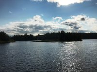
I am not making much progress on a narrative, so I will post some photos in the meantime and/or instead, depending....All taken with my iphone.
 

Attachments

  • photo10487.jpg
    photo10487.jpg
    132.7 KB · Views: 2
  • photo10488.jpg
    photo10488.jpg
    146.1 KB · Views: 2
  • photo10489.jpg
    photo10489.jpg
    199 KB · Views: 1
  • photo10490.jpg
    photo10490.jpg
    213.6 KB · Views: 1
  • photo10491.jpg
    photo10491.jpg
    78.3 KB · Views: 1
  • photo10492.jpg
    photo10492.jpg
    206.1 KB · Views: 1
  • photo10493.jpg
    photo10493.jpg
    207.5 KB · Views: 1
  • photo10494.jpg
    photo10494.jpg
    213.7 KB · Views: 1
  • photo10495.jpg
    photo10495.jpg
    226.2 KB · Views: 2
  • photo10496.jpg
    photo10496.jpg
    226.3 KB · Views: 2
  • photo10497.jpg
    photo10497.jpg
    186.2 KB · Views: 2
  • photo10498.jpg
    photo10498.jpg
    793.3 KB · Views: 2
  • photo10499.jpg
    photo10499.jpg
    253.3 KB · Views: 2
  • photo10500.jpg
    photo10500.jpg
    147.3 KB · Views: 2
Last edited:
Sorry, I posted this in the wrong section...should be Canadian Trip Reports. Maybe someone can fix it because I don't know how? Also, the photos may be too large. Let me know, please.
Erica
 
Photos were great. Down memory lane for me.. I can no longer solo canoe trip due to dementia issues in family; can't leave them home alone.
 
Beautiful pictures. Only been up that way once and it was hot summer, low water. BTW, I have moved the post over to the Canadian Trip Report side for you!

dougd
 
Well you know what they say about pictures so I'd say you've easily supplied us with 14,000 beautiful words. Thank you for these.
I will patiently wait for more before asking too many questions, such as route, your favourite moments, your happy gear choices etc.
 
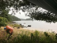
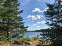
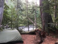
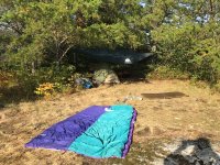
Here's Erica's campsite 2018,


Drying out after a night of hard rain.


Here's my campsite, same site, 2013. A real nice site.


u5njXzZA9_jqULuvkNi4Fjk8fsJiO2gM1ykMl5SlDIzAtRFnQi7lrhrDw7e3kd2zmDNw0li62RMzYD0osgbzQv5w9V47VT1wIh6i9XMmkrR3Noak0YRnYJ_GOkBM3MgDjk1Gok29DKZonYrpAxmDG8V_ozzSj0_KeZLSlYacJucY2AzaYgNIj7C71voaah5OViQ3sRB-RDflsF_z5TZX__GeqeUNwW1uvkjKRzDPnvyeLjBJUTPoYWol0xJkL4gAEppNiSOHKWxhD7BDEecQwzk_U8TbS_ptj5LQwSnRvaw1yTSrAcpQxoNavd_QI_MBEnUgfYJR4b194JhExmH_CtFOKCaMj3mHOy7fKX15futN5hXQ-uVezHNnWPlk75PNzTK6fLlkD1D5n6E45F03IHZcGxyBEKTST8Q1Cth49styL-Ggfe5_lVKC3N39AlRQcPjro6jlfehPj4mns2KJqlheMG7GgyCDTMjgXI4_kACg0IvpwQYJnXRJwvwfZqz8p3bSIeKxoWXEoPsNxvvutGJ7-4wU0fCsdRBU6MC-A5R9iEzUnc7pO0RbL5REJob2zK_3-zz7-0r4-QkX-zBaUm7rKFbYhvna2Gzq8Ls9E7j5PdBeCIvCbJoNuWazDJA=w640-h480-no


A view from inside the tent,

ALfkMiA6bVdLQyBogZ0lc3nhhzatuP6dqUiXHxobv1nVGL8JUKG0WXfuxv5zd-UZVZ7mEuQ9c7ZZB7ien40T3qW7olNBuKUm-sfKB85e63wHnAssY0P7kUthor4IdE2qhGyntWCS5UYXbt4P9JmJ-9CnFwzNQ02wpLiVL6fbAKgQAbxsryVVyguWwrPps52n8zR3vMwX-AXCbjcRB5NDvuCYJZm_wt_2QKAgChjIH3bfkAEFc5IvDPw4LPFxfEBgaAAjQWIvkjA2sXM8nxeWHeNx_wbfPy4cYeSmmQjR3O-kbvnCAK4WDEyFn4Amm2RcXp81H3Yw-riK3jbf_C5sXhs0TTNpmjUEQ75l9Gch_Fimz8MgPiY1zDQIt3qFUrJ4wlwxY8ad8NIDZ50pagwfRRAEFPs5WP2YQdvM1FyBUil_YQCCM2HVConZ7LSB6cYhKfJeVdGn2HcLrniHVA8TFKHWEA4N_XE5wL56Bq7_KWfZLoxVMwJpB1tfEyydB4KU0cV0FBX0wQKv3teJw82qF_JEIqOZ4CxbbtJCkvkXhuMnFz4lpgl4j800T8m83EM8y7EBGAJjLVwFq8DcSbZaNmLxOKQT9AZngzw24N_HDt4BY403JEnuc77_BWVf5_I=w640-h480-no


Nice pics Erica, Thanks
 
I paddle in the draft of great men. Robin provided me with topo maps with the campsites and various eau vives, etc. noted, which was great because LV does not have a circuit map and the helpful lady at the base did not offer to show me. Thank you, Robin, for all your help. Erica
 
What map is this loop on? And do you have any GPS points to put us in the general area? Or maybe even a GPS of the whole loop?

Google maps has about 7 different Lac Lambert in QC but none of them are in La Verendrye.
 
At the northern part of LV on 117, rt 44 heads east, take that. Long drive, (on Bing Maps (areial0 you can find Lac Lambert labeled). Lambert is east of Grand Lake Victoria.
 
OK thanks I got the ballpark area now - would love to see a GPS of the loop if one exists.
 
Ah OK the other report says Circuit 70. I don't have that map yet but I should go pick it up just to have a look. I may pop over to World of Maps this morning.
 
OK with google and reading various trip reports I have determined that this big arm off of the south west corner of Grand Lac Victoria must be Lac Lambert - though google does not have a name for it.

https://www.google.ca/maps/place/La...2ee4a09f4c1240!8m2!3d47.6287122!4d-77.5972292

MyCCR has a fairly clear description of Circuit 70 and now i see where it must be. Looks like a great route with minimal portages and out away from people. I'm going to add it to my list!

https://www.myccr.com/canoeroutes/la-verendrye-circuit-70-lac-lambert
 
All right. Some logistics.

Circuit 70 is not on the LV maps. You can purchase your own topos and then use the template at Le Domaine to label the campsites, the main chute and the eav vive. I was very lucky to have Robin send me scans of his maps. Circuit 70 is a three day trip, but it intersects with other circuits, AND right now it is the main access to 77, which I was my first choice. Access to Baie Barker is limited due to very bad condition of the roads.

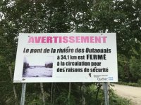
You access 70 by going north on 117 to Rt 44. Take Rt 44 about 33 km to the put-in which is marked. It is located between two closely spaced bridges over the Riviere des Ouataouais. The parking is on the north side down a very bad road. There are also two campsites there on the river which are nice, but right next to the parking. It takes 2 to 2-1/2 hours to drive there from Le Domaine.

The portage to the put in takes me 4-1/2 minutes to walk one way. All the portages I saw were in good shape and signed. You do Circuit 70 clockwise. The first half is upstream but characterized as "easy." I was able to paddle upstream solo, so I guess that does qualify as easy, thought it was not "easy" for me.

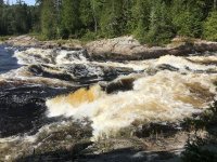
The island by the Chute has a lovely campsite and was never logged so there are some major large white pines there. Most of the campsites are beautifully situated. Some have evidence of motor boat use. All campsites showed evidence of heavy use...BUT as a result, the rest of the area is pristine. I was unable to find some of the marked campsites. Some of the campsites have had their posted signs stolen. There were four parties on the loop each weekend, motor boats most days, most people were very agreeable. The fishermen I spoke to were not catching anything.

I really am still working on a narrative....Erica
 
Your google map link goes to Lac Gaotanaga, which is on the way back, if you are going clockwise. Lac Lambert is to the east of Gaotanaga and looks like a SW extension of Grand Lac Victoria, but isn't. - I think.

I found Riviere des Ouataouais confusing. It splits up in many places and then joins together later and named lacs are in between, so the effect for me, is that RDO is a disjointed river popping up in various places on the maps.
 
Back
Top