Cree River Summer 2023 - Part 6
August 23, 2023
OK, I got ahead of myself. One should check ahead on the notes before announcing a challenge like my first rapids, which to be honest was more like a riffle with a bitty V down the center. I have sore muscles and a certain internal fatigue. I have several chores to do: repair the bow cover, charge up the electronics, general hygiene, create a bridle per instructions from Rolf. I note the duffel bag is way too heavy for me to lug up hills and back down to put into the canoe. So I stay in place for one day.
This morning dawned cold and gray. I can't complain. I just had two wonderful days.
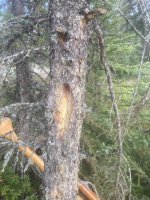
I noticed a fresh blaze near the native fish camp and followed it up the hill and into the woods. Then lost the blazes, even though the woods were open. I wonder if it led to a primitive road or snowmobile trail.

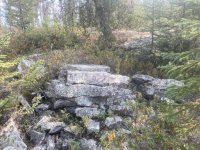
Some large flat granite rocks seemed to be stacked in a formation that might have been intentional. If so it was not clear what purpose it might have had.

I decided to try to walk down to the first set of rapids. I thought the scouting would be good practice. I could walk along the shore in the game trails. But this was not much easier than tramping through the Labrador tea tangle at the nonexistent portage. Every few yards, there were downed trees or other brush that I had to break my way through or around. I'm sure the moose had no trouble. Considering some of the rapids on the Cree River are 5K long, scouting from the shore is going to be impractical.
But I could clearly see the V running down the center of the river. On RL where I was, the water was too shallow for the canoe. Far across at RR it looked like the water was smooth. I thought it might be possible to slip down RR. Of course, this is ridiculous. If the water is piling up in a V at the center, there is not more water on RR. Sometimes I wonder about my ability to think.
Thirty years ago, or more, when I went paddling in Quebec there were no roads and no satellite devices like SPOT and Zoleo. You pushed off the shore and that was it. You were on your own. I have read many posts in this forum about their usefulness and even where in one case, it saved recep's life. I still did not want to use one. My husband, who declined to go on these extended trips, insisted I take one. We had many discussions on this. He said he was afraid I would die and he would have to come up to Canada to get my body and how horrible that would be. He said he was afraid of losing me. I capitulated for this trip and took a Zoleo and promised to check in daily.
Here are some of the problems.
- I am likely as not to drop a device into a deep lake. I already did this once, with a heavy old style water filter. If I can't check in, people will worry something has happened to me. I greatly feared helicopters racing to rescue while I am paddling around safe and happy.
- It interferes with the main reason for being in the wilderness, which is to separate one's self from the rest of the world. It is hard for me to immerse myself in nature if I have to also have a little chat daily with people back home. Zoleo has a chat function.
- It is yet another piece of electronics that must be carried and recharged if on a long trip. And if you are bringing a Zoleo, you must also have your iphone with you, accessible and charged. The Zoleo will send out an emergency signal if you don't have your phone. So, I have a flashlight, the Zoleo and the iphone that need to be kept charged. I brought two high capacity battery packs. They need to be recharged to be useful. And a Big Blue charger, which if you have to have one is super. So this comes up with another 3 pieces of electronics. I start to wonder...
- And here is about the worst: it gives you a way out. Instead of facing the challenge of the trip, I find myself constantly evaluating whether or not I want to continue. This creates, in me, a level of anxiety that is higher than worrying about the challenges ahead. Even at this point, the fish camp could pick me up and fly me out if there was an emergency.
Bald Eagles are common at the source of the Cree River. Brilliant white and black against the gray sky. Their occasional screams pierce the air. I know they are eagles even when they are distant silhouettes. Eagles soar with their wings held out straight as a ruler. Vultures and other birds of prey have V shaped silhouettes.
I made my first acquaintance with Bald Eagles as an undergraduate at the Kibbe Field Station near Warsaw, Illinois. In winter the eagles gather there to feast on the fish killed going over the dam on the Mississippi River. At night, they roost in a natural bowl in the forest named Cedar Glen Natural Area. It is one of the largest wintering concentrations of Bald Eagles in the country. It was impressive to see these big birds drop like a stone to the water and pull up a fish.
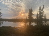
After exploring, I read some and then watched the sun descend in the southwest.

Tomorrow, now, I face the first little rapid which was not as little as it seemed. It went on and on and one around each bend. The fast water goes all the way to each shore and under the Labrador tea. There are no eddies; the stones are all small. Yikes!


