This little trip is back in my mind because of dcloots' Allagash trip and associated conversation about the longer Allagash Lake Loop, so I thought I'd write it up.
First a bit of backstory: last August several of my friends were planning a 4 day (Friday morning - Monday evening) trip to Allagash Lake from the upper Allagash Stream access point. While that sounded like fun to me, work was busy and taking a couple days off wasn't going to happen, so I relunctantly took a pass. However, I did tell the trip leader I might head up that way for a short weekend paddle and he told me I was welcome to drop in.
When Friday rolled around I was very much in the mood to get out in the woods, and the thought of a rendezvous with my friends in some Allagash Lake campsite was appealing. My plan was to put in at Indian Stream Friday evening, camp somewhere on Chamberlain, then head up Allagash Stream Saturday morning and see if I could find my friends on the lake, then return the same way to the same access point on Sunday. This plan involved a fair bit of upstream travel, so I brought my pole and my Penobscot 16, a more comfortable standup boat than my solo-soloes. My kitchen pass required that I be home for dinner on Sunday, so this would have to be a <48 hour trip.
I left my home in Bangor at about 3:30pm and munched on fast food in my car so as not to waste any daylight. The woman at the North Maine Woods checkpoint mentioned that a few hours earlier a large, scruffy party complaining of multiple flat tires had passed through on their way to Carry Trail. That sounded like my friends, but then I knew they planned to make a well-catered basecamp and was surprised about Carry Trail, rather than upper Allagash Stream, but whatevs.
I got to the Indian Stream access about 6:45pm and the put-in was routine. I paddled/bumped/waded the stream down to Eagle Lake and soon I was enjoying the scenery. However, the sun was low in the sky so I had to keep moving.
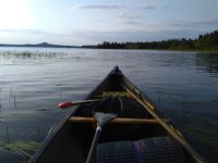
Eagle Lake
Making my way up to Lock Dam I broke out the pole, and was able to stay on my feet until the last swift where I had to hop out and wade. I don't mind getting wet in August. An easy 50 yard carry around the dam and I was on Chamberlain, my sleeping lake. Nothing to do now but find a campsite, on a Friday in August, at sundown.
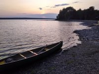
Lock Dam on Chamberlain Lake
The campsites right at the dam were open, but that felt a bit like syphilization, so I decided to continue. McCarren campsite was only about a mile away up the eastern shore of the lake.
Predictably, I got up to McCarren and the campsite was occupied. Nobody home, but gas cans on the shore. (Good form for them to make themselves obvious -- often people hide and you don't know until you land and stumble onto a tent.) OK, what's next? Consulting the map, I see that I'm almost directly across the lake from Lost Stream. I've camped there before and it's nice. Fortunately the wind is not a factor, so I head directly across the lake, figuring that will take me to a point a bit south of the campsite so I'll know to turn right.
The crossing is about 3/4 of a mile, and when I get to the Western shore it's basically dark. I paddle north as planned, and when I see the small landing at Lost Stream I also notice an electric light back in the woods. Sigh. The canoeists at the site seem very friendly, and as I paddle quietly by one of them makes a point of coming to shore to say good evening. I might have parleyed an invitation to pitch a tent there, but I'm in the mood for solitude, so I carry on.
The only other campsite on the lake north of Lost Stream is Crow's Nest. I've paddled by it a couple times and remember it as a port of last resort, but it's dark, and anyway I'm solo and don't need much.
When I get to Crow's Nest, it's really not what I had in mind. There's a small landing and then a vast causeway of bog bridging across a soggy meadow to a picnic table deep in the woods somewhere. Maybe it's nice back there, but I don't really want a tentpad a furlong from shore at this time of night.
[n.b., on older maps Crow's Nest has 3 cells, and on the newer ones only 2. I take that to mean that the rangers have responded to its high vacancy rate by doing a little rightsizing.]
While the shore south of Lost Stream is rocky and not inviting, closer to Crow's Next it starts to have a strip of gravel beach, and while following the shore I've seen a couple places that might be wide enough for my small tent. I tell myself I'll paddle north for five minutes and return to the 'Nest if I don't find anything better. Very quickly I do, and I make a simple camp on a spot just wider than my tent. No fire, and I've already had dinner, so there isn't much to it. I have some chocolate and a few sips of whiskey and then retire to my tent at 9:30. Call this site Crow's Nest 3.5. I feel a bit guilty about camping rogue in the very nicely managed Allagash, so I carefully replace the rocks that I moved to make room for my tent.

Crow's Nest 3.5
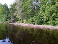
Next Morning -- LNT, no?
I awake early and am on my way up to Allagash Stream before 7. It's already warming up, and I stop briefly at the old railway trestle for a drink. I don't often use my Home Depole, but I figured this would be a good trip for it with all the upstream travel. As usual, the pole is in the way. Maybe you experienced poleurs have a better scheme for stowing it?
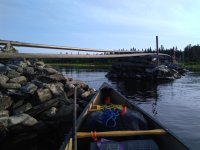
Old Railway Trestle, Chamberlain Lake
The area upstream of the trestle is a grassy open marsh, and I see two moose. [I didn't bring a real camera, and you know what a distant moose looks like in digital zoomland, so I'll skip those pics.] Upstream from the marsh I experience some sections of pole heaven, those quickwater gravelly shallows that would be a pain to paddle or wade, but that even a novice can pole through with confidence and speed. That continues most of the way up to the bridge, before things get more difficult and I have to mix in some wading and lining. Immediately around the bridge the water gets deep, and a few yards up from it there's a class 2 drop. I manage to paddle up to the spot and then jump out river left to line. However, in doing so I somehow lose the pole, and it floats downstream in the fast current. Throughout this trip the pole and the lines seemed to be at war with each other, always tangled and in each other's way.
I consider abandoning the pole to nature, or looking for it on the way back, but given that it has copper endcaps that would feel like littering, so I reluctantly head back downstream for it. I don't actually have to give up very much ground, and I'm soon back at the drop above the bridge, and I'm more careful this time as I switch modes of travel.
Near the bridge I consult the map, and it shows two rapids, both of them upstream of the bridge. Hmmm, so the hour or so of upstream travel I've made so far was only in harmless vanilla swifts?
Sure enough, my upstream travel starts to slow. There is often not enough water to float me, my gear and the boat, so I have no choice but to get out and drag. There generally isn't much open shoreline, and the stream bed is large slippery rocks, texture of greased basketballs and watermellons. I'm wearing Teva's with neoprene socks, but I find myself wishing I had hiking boots. Although it's a sunny Saturday in August I haven't seen anybody coming down the stream, and I wonder if the rangers have warned people away due to low water. (I didn't actually talk to a ranger -- this was a weekend quickie!) I tell myself that twisting an ankle up here would be most inconvenient, and I try to be careful despite impatience and growing fatigue.
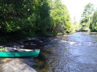
Bony Allagash Stream
Around 10am I finally get to Little Allagash Falls, where there are a few campsites and a short portage. By elevation, I'm only about halfway up to the big lake. I try to think of some reasons why that would understate my progress while I have a few snacks.
The upper half of the stream was no cakewalk. No pictures -- I was getting tired and it was a real slog! I actually considered turning back, but as always, let's just see if the lake is around that next bend, or the next. Eventually it was, and I got to the lake and Outlet campsite at about 1pm.
I consider myself a fairly energetic middle aged canoeist, but sheesh, I was completely knackered by the time I got to Outlet. I set up a chair in the sun on the beach and watched for signs of my friends. There was a cool breeze off the lake, and I was glad to be in the warm sun.

Outlet campsite on Allagash Lake
I pondered where my friends might be as I scanned the lake with binocs -- the Carry Trail / upper stream question introduced some ambiguity. I could have paddled the perimeter of the lake looking for them, but I didn't have enough energy for that, and I knew I had to do the stream again on my way home. Allagash Stream is fun when it's flowing, but with low water conditions I figured the downstream would be 2/3rds as hard as the upstream. Dragging is dragging. [As it turned out, my friends were tucked in at Ledge Point, probably sipping daquiris, but I didn't know that until Tuesday.]
Somewhat relunctantly I headed back downstream, and made camp at the site on Little Round pond just above the falls. It was a pleasant campsite, and the seclusion of it -- knowing that the stream was barely navigable and I was unlikely to see anyone -- added to the experience. There were some majestic white pines, so much so that when I heard a rumble of thunder I relocated my tent to give one of them some elbow room.
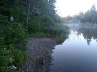
Little Allagash Falls campsite on Round Pond
The next morning I made my way back down and made a largely uneventful return.
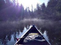
Morning light heading downstream from Little Allgash Falls
In the short trip up Indian Stream I saw two parties entering, including one that had a distinctive canoe from a Vermont manufacturer I hadn't heard of (I've forgotten the name). Nice people, but so different than the seclusion of the day before.
Back home for dinner Sunday night -- chicken curry.
First a bit of backstory: last August several of my friends were planning a 4 day (Friday morning - Monday evening) trip to Allagash Lake from the upper Allagash Stream access point. While that sounded like fun to me, work was busy and taking a couple days off wasn't going to happen, so I relunctantly took a pass. However, I did tell the trip leader I might head up that way for a short weekend paddle and he told me I was welcome to drop in.
When Friday rolled around I was very much in the mood to get out in the woods, and the thought of a rendezvous with my friends in some Allagash Lake campsite was appealing. My plan was to put in at Indian Stream Friday evening, camp somewhere on Chamberlain, then head up Allagash Stream Saturday morning and see if I could find my friends on the lake, then return the same way to the same access point on Sunday. This plan involved a fair bit of upstream travel, so I brought my pole and my Penobscot 16, a more comfortable standup boat than my solo-soloes. My kitchen pass required that I be home for dinner on Sunday, so this would have to be a <48 hour trip.
I left my home in Bangor at about 3:30pm and munched on fast food in my car so as not to waste any daylight. The woman at the North Maine Woods checkpoint mentioned that a few hours earlier a large, scruffy party complaining of multiple flat tires had passed through on their way to Carry Trail. That sounded like my friends, but then I knew they planned to make a well-catered basecamp and was surprised about Carry Trail, rather than upper Allagash Stream, but whatevs.
I got to the Indian Stream access about 6:45pm and the put-in was routine. I paddled/bumped/waded the stream down to Eagle Lake and soon I was enjoying the scenery. However, the sun was low in the sky so I had to keep moving.

Eagle Lake
Making my way up to Lock Dam I broke out the pole, and was able to stay on my feet until the last swift where I had to hop out and wade. I don't mind getting wet in August. An easy 50 yard carry around the dam and I was on Chamberlain, my sleeping lake. Nothing to do now but find a campsite, on a Friday in August, at sundown.

Lock Dam on Chamberlain Lake
The campsites right at the dam were open, but that felt a bit like syphilization, so I decided to continue. McCarren campsite was only about a mile away up the eastern shore of the lake.
Predictably, I got up to McCarren and the campsite was occupied. Nobody home, but gas cans on the shore. (Good form for them to make themselves obvious -- often people hide and you don't know until you land and stumble onto a tent.) OK, what's next? Consulting the map, I see that I'm almost directly across the lake from Lost Stream. I've camped there before and it's nice. Fortunately the wind is not a factor, so I head directly across the lake, figuring that will take me to a point a bit south of the campsite so I'll know to turn right.
The crossing is about 3/4 of a mile, and when I get to the Western shore it's basically dark. I paddle north as planned, and when I see the small landing at Lost Stream I also notice an electric light back in the woods. Sigh. The canoeists at the site seem very friendly, and as I paddle quietly by one of them makes a point of coming to shore to say good evening. I might have parleyed an invitation to pitch a tent there, but I'm in the mood for solitude, so I carry on.
The only other campsite on the lake north of Lost Stream is Crow's Nest. I've paddled by it a couple times and remember it as a port of last resort, but it's dark, and anyway I'm solo and don't need much.
When I get to Crow's Nest, it's really not what I had in mind. There's a small landing and then a vast causeway of bog bridging across a soggy meadow to a picnic table deep in the woods somewhere. Maybe it's nice back there, but I don't really want a tentpad a furlong from shore at this time of night.
[n.b., on older maps Crow's Nest has 3 cells, and on the newer ones only 2. I take that to mean that the rangers have responded to its high vacancy rate by doing a little rightsizing.]
While the shore south of Lost Stream is rocky and not inviting, closer to Crow's Next it starts to have a strip of gravel beach, and while following the shore I've seen a couple places that might be wide enough for my small tent. I tell myself I'll paddle north for five minutes and return to the 'Nest if I don't find anything better. Very quickly I do, and I make a simple camp on a spot just wider than my tent. No fire, and I've already had dinner, so there isn't much to it. I have some chocolate and a few sips of whiskey and then retire to my tent at 9:30. Call this site Crow's Nest 3.5. I feel a bit guilty about camping rogue in the very nicely managed Allagash, so I carefully replace the rocks that I moved to make room for my tent.

Crow's Nest 3.5

Next Morning -- LNT, no?
I awake early and am on my way up to Allagash Stream before 7. It's already warming up, and I stop briefly at the old railway trestle for a drink. I don't often use my Home Depole, but I figured this would be a good trip for it with all the upstream travel. As usual, the pole is in the way. Maybe you experienced poleurs have a better scheme for stowing it?

Old Railway Trestle, Chamberlain Lake
The area upstream of the trestle is a grassy open marsh, and I see two moose. [I didn't bring a real camera, and you know what a distant moose looks like in digital zoomland, so I'll skip those pics.] Upstream from the marsh I experience some sections of pole heaven, those quickwater gravelly shallows that would be a pain to paddle or wade, but that even a novice can pole through with confidence and speed. That continues most of the way up to the bridge, before things get more difficult and I have to mix in some wading and lining. Immediately around the bridge the water gets deep, and a few yards up from it there's a class 2 drop. I manage to paddle up to the spot and then jump out river left to line. However, in doing so I somehow lose the pole, and it floats downstream in the fast current. Throughout this trip the pole and the lines seemed to be at war with each other, always tangled and in each other's way.
I consider abandoning the pole to nature, or looking for it on the way back, but given that it has copper endcaps that would feel like littering, so I reluctantly head back downstream for it. I don't actually have to give up very much ground, and I'm soon back at the drop above the bridge, and I'm more careful this time as I switch modes of travel.
Near the bridge I consult the map, and it shows two rapids, both of them upstream of the bridge. Hmmm, so the hour or so of upstream travel I've made so far was only in harmless vanilla swifts?
Sure enough, my upstream travel starts to slow. There is often not enough water to float me, my gear and the boat, so I have no choice but to get out and drag. There generally isn't much open shoreline, and the stream bed is large slippery rocks, texture of greased basketballs and watermellons. I'm wearing Teva's with neoprene socks, but I find myself wishing I had hiking boots. Although it's a sunny Saturday in August I haven't seen anybody coming down the stream, and I wonder if the rangers have warned people away due to low water. (I didn't actually talk to a ranger -- this was a weekend quickie!) I tell myself that twisting an ankle up here would be most inconvenient, and I try to be careful despite impatience and growing fatigue.

Bony Allagash Stream
Around 10am I finally get to Little Allagash Falls, where there are a few campsites and a short portage. By elevation, I'm only about halfway up to the big lake. I try to think of some reasons why that would understate my progress while I have a few snacks.
The upper half of the stream was no cakewalk. No pictures -- I was getting tired and it was a real slog! I actually considered turning back, but as always, let's just see if the lake is around that next bend, or the next. Eventually it was, and I got to the lake and Outlet campsite at about 1pm.
I consider myself a fairly energetic middle aged canoeist, but sheesh, I was completely knackered by the time I got to Outlet. I set up a chair in the sun on the beach and watched for signs of my friends. There was a cool breeze off the lake, and I was glad to be in the warm sun.

Outlet campsite on Allagash Lake
I pondered where my friends might be as I scanned the lake with binocs -- the Carry Trail / upper stream question introduced some ambiguity. I could have paddled the perimeter of the lake looking for them, but I didn't have enough energy for that, and I knew I had to do the stream again on my way home. Allagash Stream is fun when it's flowing, but with low water conditions I figured the downstream would be 2/3rds as hard as the upstream. Dragging is dragging. [As it turned out, my friends were tucked in at Ledge Point, probably sipping daquiris, but I didn't know that until Tuesday.]
Somewhat relunctantly I headed back downstream, and made camp at the site on Little Round pond just above the falls. It was a pleasant campsite, and the seclusion of it -- knowing that the stream was barely navigable and I was unlikely to see anyone -- added to the experience. There were some majestic white pines, so much so that when I heard a rumble of thunder I relocated my tent to give one of them some elbow room.

Little Allagash Falls campsite on Round Pond
The next morning I made my way back down and made a largely uneventful return.

Morning light heading downstream from Little Allgash Falls
In the short trip up Indian Stream I saw two parties entering, including one that had a distinctive canoe from a Vermont manufacturer I hadn't heard of (I've forgotten the name). Nice people, but so different than the seclusion of the day before.
Back home for dinner Sunday night -- chicken curry.

